How to use this guide (and why snowmelt timing matters)
Salt Lake City is one of the few large American cities with serious waterfalls within an hour of downtown. The reason is geography: the Wasatch Range rises abruptly east of the valley, and a handful of glacier-carved canyons — Big Cottonwood, Little Cottonwood, and the smaller drainages north toward Layton — collect snow all winter and release it as runoff in spring. Most of the falls here are not towering year-round rivers. They are snowmelt-driven, which means timing is everything. A trail that ends at a thundering cascade in late May can be a quiet trickle by August.
That seasonal swing is the single most important thing to understand before you go. Across the Wasatch, peak flow generally lands in the spring snowmelt window of roughly April through June, with the exact timing depending on elevation and how big the winter snowpack was. Lower-elevation falls on the valley benches melt out first; high canyon falls near the ski resorts run later and longer. The U.S. Forest Service and Utah's snowpack monitoring (via USDA SNOTEL sites) are the practical way to gauge a given year — a heavy snow year pushes strong flows deeper into summer, while a dry winter can leave some falls disappointing by July.
A word on the numbers in this guide. Reported waterfall heights vary by source and by how the measurement was taken — a single uninterrupted plunge versus the cumulative drop of a multi-tier cascade, and field estimate versus survey. We give commonly documented figures and flag where a number is a rough estimate or where sources disagree. Trail distances are drawn from agency descriptions and trail databases and are noted as round-trip where known; conditions, closures, and parking fill up fast on summer weekends, so always check the managing agency before you drive up.
We have grouped the falls by trip type: the Cottonwood Canyons right behind the city, the northern Wasatch benches, the Provo and Mount Timpanogos cluster a little farther south, the high Uinta country on the Mirror Lake Highway, and a final set of bigger day-trips into southern Utah's redrock that are worth the longer drive.
The Cottonwood Canyons: waterfalls in the city's backyard
The two Cottonwood Canyons — Big and Little — are the closest real mountains to Salt Lake City, and they hold the falls most locals hit first. The standout family destination is Donut Falls (slug: donut-falls-ut) in Big Cottonwood Canyon, where Mill D South Fork (part of the Big Cottonwood Creek drainage) drops about 30 feet and pours through a hole it has carved in the rock — the 'donut' that gives the fall its name. The hike is about 3.4 miles round trip and rated easy, making it a popular pick with kids, but the trailhead parking is small and fills early on summer weekends. Because Donut Falls sits higher in the canyon, its best window is the summer stretch from June through September, after the upper snow has melted and the access road and trail are clear.
Over in Little Cottonwood Canyon, Lisa Falls (slug: lisa-falls-ut) is one of the quickest payoffs around: a roughly 0.45-mile, easy walk leads to a cascade dropping about 30 feet down a granite face on Lisa Falls Gulch, a tributary of Little Cottonwood Creek, near Alta. It is short enough to slot into an afternoon, and the granite slabs are a striking backdrop, but Lisa Falls is firmly snowmelt-fed — its sweet spot is late spring into early summer, and by late summer it can thin to a fraction of its peak. This is a watch-your-footing spot rather than a swimming hole; the rock above the falls is steep and has been the site of accidents, so stay on the established viewing area.
Both Cottonwood Canyons are watershed-protected, which shapes the etiquette here in ways visitors from elsewhere may not expect: dogs are prohibited throughout the canyons to protect the city's drinking water, and that rule is enforced. The Uinta-Wasatch-Cache National Forest manages the surrounding land, and during winter and high-runoff periods avalanche control and flooding can close roads with little notice. Plan a Cottonwood waterfall trip as an early-start, weekday-if-possible outing, and have a backup in mind.
North of the city: bench-and-canyon falls toward Layton and Sandy
Heading north along the Wasatch Front, Adams Canyon Falls (slug: adams-canyon-falls-ut) above Layton is the marquee hike of the northern benches. The trail climbs roughly 3.5 miles round trip — rated moderate, with a steady, rooty grind that earns its reward — to a plunge of about 40 feet where the North Fork of Holmes Creek drops into a slot of rock and ferns. On the Uinta-Wasatch-Cache National Forest land that frames the canyon, the fall runs from spring through fall (roughly April to October), but it is at its most dramatic during the spring snowmelt when Holmes Creek is loud and full. The lower switchbacks are exposed and hot in midsummer afternoons, so an early start helps.
Closer to the southern end of the valley, Rocky Mouth Falls (slug: rocky-mouth-falls-ut) in Sandy is the kind of urban-edge waterfall that surprises first-time visitors. The trailhead is tucked into a residential neighborhood, and a short, roughly 0.8-mile easy hike — including a staircase built into the hillside — climbs to a 70-foot cascade on Rocky Mouth Creek. Land here is split between Sandy City and the Uinta-Wasatch-Cache National Forest, and because the access passes directly behind homes, the posted rules about hours, parking, and quiet are taken seriously. Like the rest of the front-range falls, Rocky Mouth is snowmelt-driven and peaks in the spring window of roughly April through June; come in May for the fullest flow.
These bench falls share a practical advantage: they melt out earlier than the high-canyon falls, so they are often running well in April and early May when the Cottonwood Canyon trails are still snowbound or muddy. They make excellent shoulder-season targets when you want moving water but the high country is not ready yet.
The Provo and Mount Timpanogos cluster
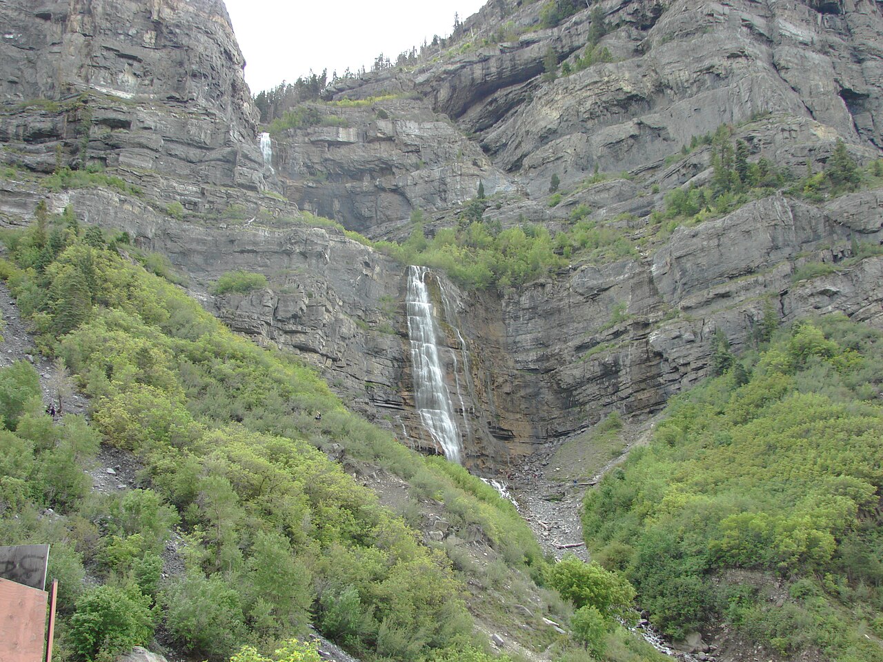
An hour south of Salt Lake City, the country around Provo and Mount Timpanogos holds some of the most photographed falls in the state. Bridal Veil Falls (slug: bridal-veil-falls-ut) in Provo Canyon is the showpiece — a tiered cascade plunging a commonly cited 607 feet down the canyon wall on a Provo River tributary, managed as a Utah County park. It is essentially roadside: a paved path of about 0.3 miles from the parking area gets you to the base, making it the rare big waterfall that is genuinely easy to reach. As with most Wasatch falls, the spring snowmelt months of April through June bring the heaviest flow. Note the 607-foot figure is the cumulative drop of a multi-stage cascade rather than one sheer plunge, which is typical for falls of this style.
For a hiker's payoff in the same area, Stewart Falls (slug: stewart-falls-ut) drops about 200 feet in tiers down the Mount Timpanogos drainage, on Stewart Creek within the Uinta-Wasatch-Cache National Forest. The standard route runs roughly 3.5 miles round trip at a moderate grade, often starting from the Aspen Grove area, and the season is generous — late spring through fall, roughly May into October, with golden aspens making autumn a favorite. Just to the north near Pleasant Grove, Battle Creek Falls (slug: battle-creek-falls-ut) is an easier option: a horsetail fall reached by a short, roughly 1.6-mile easy hike on Battle Creek, also on national forest land, running spring through fall. Heights for Battle Creek vary enough between sources that we do not cite a single figure here.
Two more sit at the edges of this cluster. Grotto Falls (slug: grotto-falls-ut) up Payson Canyon, southwest of Provo, is a short and easy roughly 0.6-mile walk to a cascade in the Peteetneet Creek drainage; it is a classic autumn-color destination, with a season running spring through fall (March to October). And on the higher road toward the Uintas, Provo River Falls (slug: provo-river-falls-ut) along the Mirror Lake Highway near Kamas is a tiered set of drops on the Provo River, essentially roadside at about a 0.2-mile walk. Because it sits high, its season is tied to the highway: roughly late May through October, when the Mirror Lake Highway is open and free of snow. Always confirm the highway status with the Forest Service before driving up early or late in the season.
Worth the longer drive: southern Utah's redrock falls
Salt Lake City makes a natural launch point for southern Utah, and a few of the state's most memorable waterfalls are worth the multi-hour drive. The pair on Calf Creek inside Grand Staircase–Escalante National Monument are the headliners. Lower Calf Creek Falls (slug: lower-calf-creek-falls-ut) is a 126-foot horsetail spilling into a desert pool — reached by a roughly 6-mile round-trip, moderate sand-and-slickrock hike from the BLM campground near Escalante, best in the milder spring and fall windows (April–May and September–October) when the canyon is not punishingly hot. Its quieter sibling, Upper Calf Creek Falls (slug: upper-calf-creek-falls-ut), is an 88-foot plunge on the same creek, reached by a steeper but shorter roughly 2.2-mile round-trip moderate trail that drops sharply over slickrock; same spring-and-fall season, same BLM management. Both are desert hikes — carry far more water than you think you need.
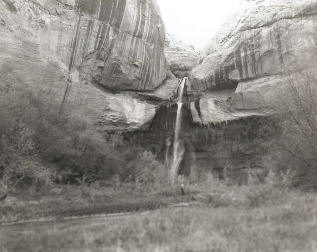
To the west near Kanarraville, Kanarra Falls (slug: kanarra-falls-ut) is a slot-canyon experience as much as a waterfall: a roughly 3.8-mile round-trip moderate hike that wades up Kanarra Creek to cascades framed by glowing narrows, with a wooden ladder bolted to one of the drops. The town of Kanarraville and the BLM jointly manage access, and a paid permit with a daily visitor cap is required — reserve ahead, because day-of spots are not guaranteed. The season runs roughly late spring to early fall; because the route is in the creek, flash-flood risk is real, and you should never enter the canyon with thunderstorms in the forecast.
Two smaller southern falls round out the list for travelers already down that way. Tropic Ditch Falls (slug: tropic-ditch-falls-mossy-cave-ut), at the Mossy Cave trail inside Bryce Canyon National Park, is a roughly 20-foot cascade reached by an easy 0.9-mile hike; oddly, it flows because of an 1890s irrigation ditch (Tropic Ditch) that diverts water through Water Canyon, and its season runs spring through fall (April–October). Farther west on the Markagunt Plateau, Cascade Falls (slug: cascade-falls-ut) is the surface outlet of Navajo Lake — water sinks underground and re-emerges from a cliff face as the headwaters of the North Fork of the Virgin River. A short, easy roughly 1.2-mile hike in the Dixie National Forest near Duck Creek Village reaches the overlook, best in summer to early fall when the high plateau road is open.
Planning, safety, and seasonal strategy
If you want a single rule of thumb: chase elevation with the calendar. In April and early May, target the lower benches — Rocky Mouth above Sandy and Adams Canyon above Layton melt out first and run hard. By late May and June, the Provo-area and mid-canyon falls hit their stride, and Bridal Veil and Stewart Falls peak. By high summer, shift up to Donut Falls and the Mirror Lake Highway falls like Provo River Falls, which depend on the snow clearing the high country. Southern Utah's Calf Creek and Kanarra falls are best treated as spring and fall trips to dodge the desert heat.
Cottonwood Canyon watershed rules deserve a second mention because they catch visitors off guard: no dogs are allowed in Big or Little Cottonwood Canyons, full stop, to protect Salt Lake City's drinking water. Parking at popular trailheads like Donut Falls fills early, and the canyons have toll and shuttle programs that change year to year — check current conditions before you go. For the snowpack-driven falls generally, a quick look at the season's SNOTEL snow data tells you whether you are headed into a strong runoff year or a thin one.
Safety in the Wasatch is mostly about water and rock. Spring runoff makes creeks faster and colder than they look, wet granite and slickrock are treacherous, and several of these falls — Lisa Falls and the Cottonwood drops among them — have steep terrain above the viewing areas where scrambling has led to injuries. Stay on established trails and overlooks, keep children close near moving water, and never enter a slot canyon like Kanarra when storms are anywhere in the forecast. Desert hikes to Calf Creek demand sun protection and far more water than a mountain hike of the same length. Treat every posted closure, permit requirement, and parking rule as part of the trip, not an obstacle to it.