How to Use This Guide
Oregon is one of the densest waterfall states in the country. The World Waterfall Database and the USGS Geographic Names Information System (GNIS) catalog hundreds of named falls across the Cascades, the Columbia River Gorge, the Coast Range, and the southern Umpqua and Rogue drainages. No single guide can be comprehensive, and this one does not pretend to be. What follows is a curated set of six waterfalls chosen because each is well documented in public records, reliably accessible to most visitors, and representative of a different corner of the state's geology and geography.
Every fact below is drawn from public-records sources: the U.S. Forest Service recreation pages for falls on national forest land, Oregon State Parks for those inside state parks, USGS GNIS for place names and watercourses, and the World Waterfall Database for height and morphology. Where reported heights disagree between sources — which happens often, because some figures measure a single sheer plunge and others sum a multi-step cascade — this guide flags the uncertainty rather than presenting one number as definitive.
The six are ordered roughly by height, from the tallest down. That ordering is a convenience, not a ranking of quality; a 97-foot fall in a snowbound canyon near Bend can be every bit as memorable as a 620-foot showpiece off an interstate. Pay closer attention to the access notes and seasonal timing than to the raw numbers, because those are what determine whether your visit is a quiet roadside stop or a washed-out, road-gated disappointment.
Multnomah Falls — Oregon's Tallest and Most Visited
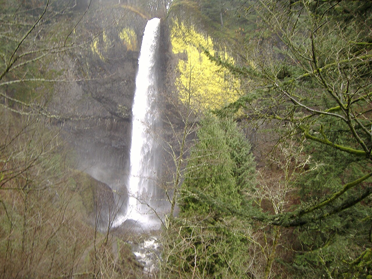
Multnomah Falls is the waterfall most people picture when they think of Oregon. At a documented 620 feet it is the tallest in the state, and it is a tiered fall: a long upper drop of roughly 542 feet, a short stepped middle reach, and a lower drop of about 69 feet beneath the much-photographed Benson Footbridge. It sits on Multnomah Creek in the Columbia River Gorge National Scenic Area, managed by the U.S. Forest Service, just off the Historic Columbia River Highway near Corbett. Because the creek is spring-fed from the basalt plateau above, the falls run year-round rather than drying to a trickle in late summer.
Access is genuinely easy, which is a large part of why it draws more than two million visitors a year and ranks among the most-visited natural sites in the Pacific Northwest. The lower viewpoint is essentially at the parking area; the paved path to the Benson Footbridge is a roughly 0.2-mile walk. A steeper switchbacking trail continues to the top of the upper falls for those who want the full perspective. Plan for crowds, and check current Forest Service rules before you go — in peak season (roughly late May through early September) a timed-use permit has been required for daytime access, and conditions change year to year.
Best flow is in the wetter months of late fall through spring, November through May, when winter rain and snowmelt swell Multnomah Creek. The falls remain impressive in summer because of their spring-fed source, but the surrounding gorge greenery and the sheer water volume peak in the cooler half of the year. Winter cold snaps occasionally rime the lower falls in ice, which is striking but worth approaching with caution.
Salt Creek Falls and Latourell Falls — Tall Plunges, Two Very Different Settings
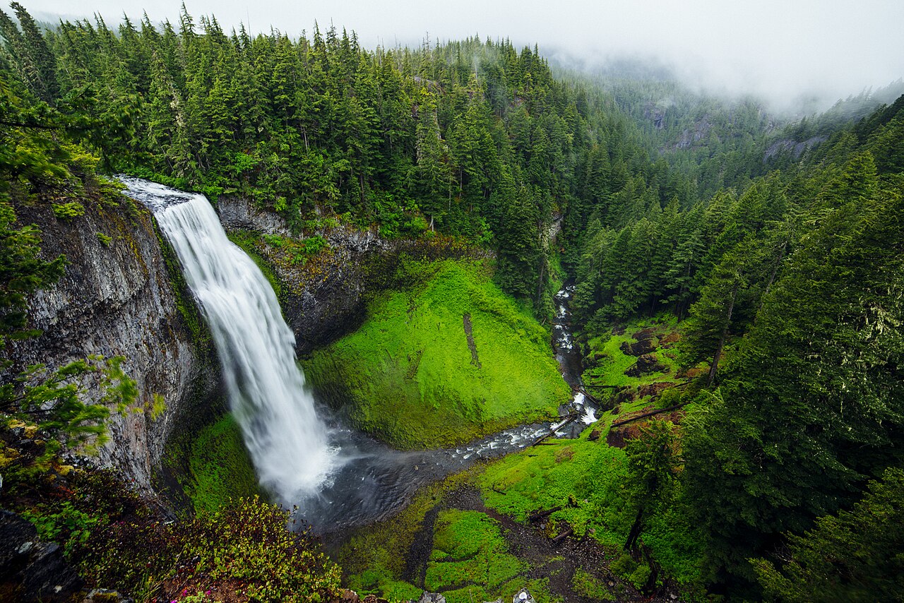
Salt Creek Falls is one of Oregon's tallest single-drop waterfalls at 286 feet, a clean plunge on Salt Creek near Willamette Pass, managed within the Willamette National Forest near Oakridge. Sources differ on exactly where it sits in the state's height rankings — the Forest Service describes it as Oregon's second-highest single drop, while other catalogs place it third behind Multnomah and Watson Falls — so treat any 'second-tallest' claim as approximate. What is not in dispute is the access: an observation platform sits only about a tenth of a mile from the parking lot, making this roughly a 0.2-mile roadside stop. Because the falls are fed largely by snowmelt high in the Cascades, the strongest flow comes during the late-spring melt, roughly May into June.
Latourell Falls offers a tall plunge of a completely different character. At 224 feet it drops over a sheer wall of columnar basalt in Guy W. Talbot State Park, managed by Oregon State Parks, on the western edge of the Columbia Gorge near the hamlet of Latourell. Its signature feature is the broad splash of chartreuse-yellow lichen — golden cobblestone lichen, Pleopsidium flavum — staining the dark basalt beside the falling water, a contrast that makes it one of the most photographed falls in the gorge. The lower viewpoint is a very short paved walk of about 0.2 mile from the lot, and a loop trail climbs to an upper fall for those wanting more.
The two falls bracket Oregon's two dominant waterfall seasons. Latourell, fed by Pacific storms rolling up the gorge, runs hardest in the wet winter and spring window of November through May. Salt Creek, higher and colder, depends on the snowpack melting out, so it peaks weeks later in late spring. If your trip is in April, both can be excellent; by July, Latourell will have eased off while Salt Creek may still be running strong on residual melt.
South Falls — The Anchor of the Trail of Ten Falls
South Falls is the centerpiece of Silver Falls State Park, the largest state park in Oregon and home to the celebrated Trail of Ten Falls. At 177 feet, this plunge on the South Fork of Silver Creek is not the tallest fall in this guide, but it is one of the most rewarding to stand beneath — the trail leads directly behind the curtain of water into a mossy basalt amphitheater, one of several walk-behind falls in the park. The park is managed by Oregon State Parks near Silverton, in the foothills east of Salem.
Access is a short hike rather than a roadside stop: figure on roughly 0.7 mile of trail to reach and circle South Falls from the day-use area, on well-maintained paths. Visitors who want more can continue onto the full Trail of Ten Falls, a loop of about 7 miles linking ten named waterfalls, several of them over 100 feet, through a forested canyon that stays accessible year-round. A modest day-use parking fee applies, and the South Falls lot fills early on summer weekends.
Like the gorge falls, Silver Creek is rain-and-runoff fed rather than snowmelt fed, so South Falls runs most powerfully from late fall through spring, November through May. Spring adds wildflowers and vivid green moss to the canyon walls; winter brings the heaviest water and the smallest crowds. Late summer flow drops noticeably, though the walk-behind experience remains worthwhile in any season.
Toketee Falls and Tumalo Falls — Southern and Central Oregon's Basalt Gems
Toketee Falls, on the North Umpqua River in the Umpqua National Forest near Roseburg, is one of the most recognizable falls in the state thanks to the wall of columnar basalt framing its two-step, 113-foot drop — a short upper step of roughly 28 feet above a sheer lower plunge of about 85 feet into a deep green pool. The name comes from a Chinook Jargon word meaning 'graceful.' A distinctive quirk: the river's flow here is regulated by an upstream diversion built in 1949 for the North Umpqua Hydroelectric Project, which routes much of the water to Toketee Lake. The practical upside is a remarkably consistent display year-round rather than the seasonal feast-or-famine of rain-fed falls. Reaching the viewpoint is a short hike of about 0.8 mile through old-growth forest.
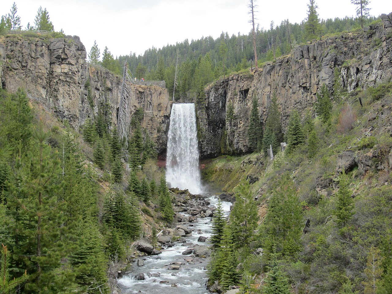
Tumalo Falls sits on the other side of the Cascades, in the high country of the Deschutes National Forest just west of Bend, where Tumalo Creek drops 97 feet over a dark cliff face. The viewpoint is effectively roadside — a walk of only about a tenth of a mile from the trailhead lot — but with a major seasonal catch. Forest Road 4603, the access road, is gated through the snow season, generally from November into May. When the gate is closed, reaching the falls means walking, skiing, snowshoeing, or fat-biking roughly 2.5 miles each way from the winter closure point, which turns a quick stop into a real outing.
These two illustrate why timing matters as much as distance. Toketee, with its regulated flow, is a genuine year-round destination, making it a reliable winter option when much of Oregon's high country is buried. Tumalo is best from late spring through summer, roughly June through September, once the access road reopens and Tumalo Creek is still running full on lingering snowmelt. Trying to drive to Tumalo Falls in March will simply leave you at a locked gate.
Planning Notes, Heights, and Seasons
A useful way to read this set is by water source, because that, more than height, predicts when a fall performs. The rain-and-runoff falls — Multnomah, Latourell, and South Falls — peak in the wet winter-and-spring window of November through May and ease off in late summer. The snowmelt-dependent fall, Salt Creek, peaks a beat later during the late-spring melt of May and June. Toketee runs steadily year-round because a dam meters its flow, and Tumalo is a summer fall by necessity, gated behind snow until its access road reopens.
Access ranges from genuinely roadside to a short hike. Salt Creek Falls and Tumalo Falls are essentially walk-up viewpoints of about 0.1 to 0.2 mile, though Tumalo's road closure is the catch. Multnomah and Latourell offer paved lower viewpoints around 0.2 mile out, with optional climbs for more. Toketee is a forest hike of roughly 0.8 mile, and South Falls about 0.7 mile, with the full Trail of Ten Falls loop running near 7 miles for those who want the complete circuit.
Finally, a word on the numbers. The heights cited here — 620, 286, 224, 177, 113, and 97 feet — come from public-records and waterfall-database sources, but reported figures vary by measurement method. Some sources give a single sheer plunge; others sum every step of a tiered cascade, which is why Multnomah's 620 feet and Toketee's 113 feet are best understood as cumulative figures across multiple drops. Use these numbers to compare scale, not as surveyed-to-the-foot precision, and always check the current managing agency's page for permits, road status, and seasonal closures before you drive out.