Why North Carolina Is Waterfall Country
The western quarter of North Carolina sits along the Blue Ridge Escarpment, the steep edge where the high Appalachian plateau drops toward the South Carolina and Georgia piedmont. Rivers that meander gently across the plateau suddenly hit that drop and fall hundreds of feet in a short distance, and the band of land around Brevard, Cashiers, Highlands, and Sapphire holds one of the densest concentrations of waterfalls in the eastern United States. Most are on public land managed by the U.S. Forest Service (Pisgah and Nantahala National Forests), the National Park Service (Blue Ridge Parkway), or North Carolina State Parks, which is why so many are open to the public and reasonably well documented.
This guide is a curated set of five well-documented falls, not a complete inventory. North Carolina has far more — hundreds appear in the USGS Geographic Names Information System (GNIS) alone, and reference sites like the World Waterfall Database catalog many more, including unnamed and seasonal drops. The five here were chosen because they span the realistic range of what a visitor actually weighs: a 411-foot signature plunge, a couple of roadside falls you can see in five minutes, a genuine backcountry hike, and a famous gorge waterfall on the Parkway. Between them they cover the spectrum from wheelchair-accessible overlook to a three-mile trail.
One honest caveat runs through everything below: reported waterfall heights vary a lot by source and by method. Agencies and databases measure differently — some report a single vertical plunge, others the cumulative drop of a multi-tiered cascade, and a few round generously. Where the managing agency publishes a number we use it, but treat the figures as the documented estimate rather than a surveyed certainty.
Whitewater Falls — The Tall One
Whitewater Falls, on the Whitewater River in the Nantahala National Forest near Sapphire, is the headline act. The U.S. Forest Service lists it at 411 feet, and it is frequently promoted as the highest waterfall east of the Rockies. That superlative deserves an asterisk: the title is contested depending on how you define and measure a waterfall, and several other falls in Virginia, Georgia, and even elsewhere in North Carolina have laid claim to it. What is not in dispute is that this is a genuinely massive, tiered cascade — water sheets and tumbles down a broad rock face in a series of drops rather than one clean plunge.
Access is easy relative to the payoff. A paved walkway of roughly 0.6 miles round trip leads from the parking area to an upper overlook with a head-on view of the falls. For a closer look, a stairway of about 150 wooden steps descends to a lower overlook — worth it if your knees are willing, since the climb back up is the real workout. The overlooks are fenced for a reason: the rocks above and around the falls are notoriously slick and have been the site of fatal accidents. Stay behind the railings.
Whitewater runs well year-round but is at its most thunderous during spring snowmelt and after heavy rain, roughly March through May. There is a parking fee at the developed site. Note that the falls straddle the state line — the upper falls are in North Carolina, while a separate lower section drops into South Carolina — so directions and trail descriptions sometimes blur the two.
The Roadside Pair — Looking Glass Falls and Dry Falls
If your time or mobility is limited, two falls deliver outsized scenery for almost no effort. Looking Glass Falls, on Looking Glass Creek in the Pisgah National Forest near Brevard, is the postcard waterfall of western North Carolina: a clean, roughly 60-foot plunge over a broad rock face, visible straight from the road on US 276. You can see it from a roadside pull-off without leaving the pavement, or descend a short stairway of about 0.2 miles to creek level for a fuller view. It runs reliably all year and is busiest on summer weekends; spring and after heavy rain (March through June) is when it's fullest.
Dry Falls, on the Cullasaja River near Highlands in the Nantahala National Forest, has a trick the others don't: you can walk behind it. The roughly 75-foot plunge pours over an overhanging rock shelf, and a short paved path of about 0.2 miles leads down and around behind the curtain of water, through a shallow rock alcove. The name comes from the fact that you can usually pass behind without getting soaked — though in high flow, expect mist and spray regardless. It sits right off US 64 in the Cullasaja Gorge between Franklin and Highlands, one of several falls strung along that dramatic stretch of road.
Both of these are ideal for families, mixed-ability groups, or a stop on a longer drive. Because they require so little hiking, they also absorb the most crowds — go early in the day or midweek if you want the place closer to yourself. Like all waterfalls here, they peak after spring rain and snowmelt and can thin out during a dry late summer.
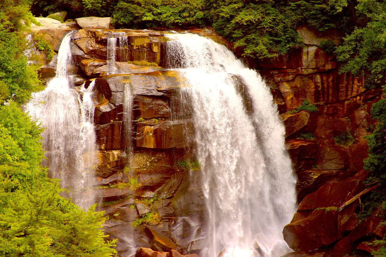
Rainbow Falls — The Hike That Earns It
Rainbow Falls is the one on this list that asks something of you. It sits on the Horsepasture River, a federally designated Wild and Scenic River, on land managed jointly by the Pisgah National Forest and North Carolina's Gorges State Park near Sapphire. The roughly 150-foot plunge is the single most powerful free-falling cataract in the group — in high flow it throws enough mist to generate the rainbows it's named for, and you can feel the spray well before you reach the base.
The trail is about 3 miles round trip and rated moderate, most conveniently accessed from the Grassy Ridge parking area in Gorges State Park. The catch is the terrain: the route descends toward the river on the way in, which means the return is a steady uphill climb. Wear real shoes, carry water, and give yourself more time than the mileage suggests. The rocks near the falls are wet and dangerously slick — this stretch of the Horsepasture has a long record of serious accidents, so resist the urge to scramble for a better angle.
Rainbow Falls is also a gateway to more water. The same trail continues upriver to Turtleback Falls, a lower sliding drop, and within the broader corridor sit Drift Falls and other cascades on the Horsepasture. The whole valley is best in spring and after heavy rain, roughly April through June, when the river is loud and the plunge pool churns. Gorges State Park publishes current trail and parking information worth checking before you go.
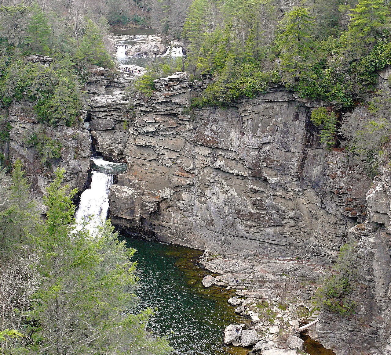
Linville Falls — The Gorge Classic
Linville Falls, on the Linville River, is the most famous waterfall on the Blue Ridge Parkway and one of the best known in the southern Appalachians. It's managed by the National Park Service as part of the Parkway, with a visitor center at roughly Milepost 316 near the village of Linville Falls. Rather than one dramatic drop, it's a multi-tiered sequence: the river splits through a pair of small upper falls, funnels into a narrow gorge, and finishes in a high-volume plunge into the Linville Gorge — often called the 'Grand Canyon of the Southern Appalachians.' Because the height is spread across several tiers, single published numbers for Linville Falls vary, and our source data leaves the figure open rather than fixing a misleadingly precise total.
The reward here is the variety of vantage points. From the visitor center, the moderate Erwins View Trail runs about 1.6 miles round trip to a series of overlooks that frame the falls and gorge from different heights and angles — this is the route most visitors take. A shorter, easier path leads to the top of the upper falls, while steeper, more strenuous trails on the far side drop toward the plunge basin for those wanting a harder hike. Choose the overlook trail for the classic photograph; choose the lower routes if you want to earn the view.
Linville runs strongest in spring and after heavy rain, roughly April through June, when the gorge is full of sound. As an NPS site on the Parkway, access depends on the road being open — the Blue Ridge Parkway closes sections in winter and during weather events — so confirm Parkway status before planning a trip. Fall brings spectacular foliage and correspondingly heavy crowds.
Planning, Safety, and Honest Expectations
Timing is everything with waterfalls. Every fall on this list is at its most impressive during spring snowmelt and in the days after heavy rain — broadly March through June across the region. Visit during a dry spell in late summer or early fall and even the big drops can shrink to a fraction of their peak. If a powerful flow matters to you, plan around recent rainfall rather than the calendar alone, and check current conditions with the managing agency.
Safety is not optional. The leading cause of serious injury and death at North Carolina waterfalls is people climbing on wet rocks above or beside the falls. The rock is coated in algae and spray and offers far less grip than it looks — stay on marked trails and behind railings at overlooks. This applies even at the easy roadside falls. Take particular care at Whitewater Falls and along the Horsepasture River near Rainbow Falls, both of which have repeated fatal-accident histories.
Finally, a reminder on scope and on the numbers. These five are a deliberately small, representative selection — North Carolina has hundreds of documented waterfalls in USGS GNIS and reference databases, and many fine ones (Bridal Veil, Turtleback, Crabtree, Glen Falls, and others) didn't make this short list. The heights cited above come from managing agencies and standard references and should be read as documented estimates, not surveyed measurements, since sources differ on whether they count a single drop or a full multi-tier cascade. Use the official Forest Service, National Park Service, and NC State Parks pages for the most current access, fee, and closure details before any trip.