How to read this guide (and a note on heights)
California has thousands of waterfalls scattered across the Sierra Nevada, the Coast Ranges, the southern California mountains, and the volcanic country up north. This is not a complete census of them. It is a curated set of eleven documented, named falls — the ones with the strongest combination of scale, distinctiveness, public access, and reliable records from agencies like the National Park Service, the U.S. Forest Service, and California State Parks. If a fall you love is not here, that is a limit of scope, not a judgment.
A word about the numbers, because waterfall heights are slipperier than they look. A reported height depends on how it is measured: the tallest single uninterrupted drop, or the cumulative fall of a multi-tier cascade from the top of the first plunge to the bottom of the last. Yosemite Falls is the classic example — its widely cited 2,425 feet is the sum of three sections, not one continuous sheet of water. Different sources, using different methods, will disagree by tens or even hundreds of feet. We give the commonly documented figures here and flag where a number is cumulative rather than a single plunge.
We have grouped the falls roughly by what kind of trip they are: the giants of Yosemite Valley, the year-round spring-fed falls of the north, the coastal tidefalls, and the day-hike falls near major cities. Trail distances are round-trip where noted, drawn from the managing agency's own descriptions. Always check the current conditions page for your destination before you go — trails close, overlooks get repaired, and the season makes or breaks most of these.
The Yosemite Valley giants
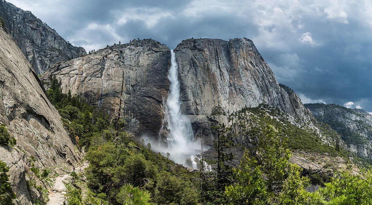
No state-by-state list of American waterfalls is plausible without Yosemite, and the valley alone could fill this guide. Yosemite Falls is the headliner: at a documented 2,425 feet it is one of the tallest waterfalls in North America, dropping in three distinct sections — an Upper Fall of roughly 1,430 feet, a stretch of middle cascades, and a Lower Fall near the valley floor. The catch is that it is fed by Yosemite Creek, not a glacier or a spring, so it is fueled by snowmelt and can slow to a trickle or dry up entirely by late summer. Time your visit for the spring melt, roughly April through June. You can reach the base of the Lower Fall on a short, mostly flat loop; the full Upper Yosemite Fall trail is a strenuous climb of about 7.2 miles round trip.
Bridalveil Fall is the valley's other great icon and the first major fall many visitors see when entering from the west. At about 620 feet it plunges off a hanging valley in a single dramatic drop, and because it is one of the more wind-exposed falls it often blows sideways into the misty 'veil' that gives it its name. The paved approach from the parking area is roughly a half mile, making it one of the most accessible big falls in the park. Like Yosemite Falls it runs hardest in the spring melt, though it holds water somewhat longer than its neighbors.
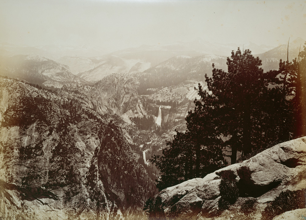
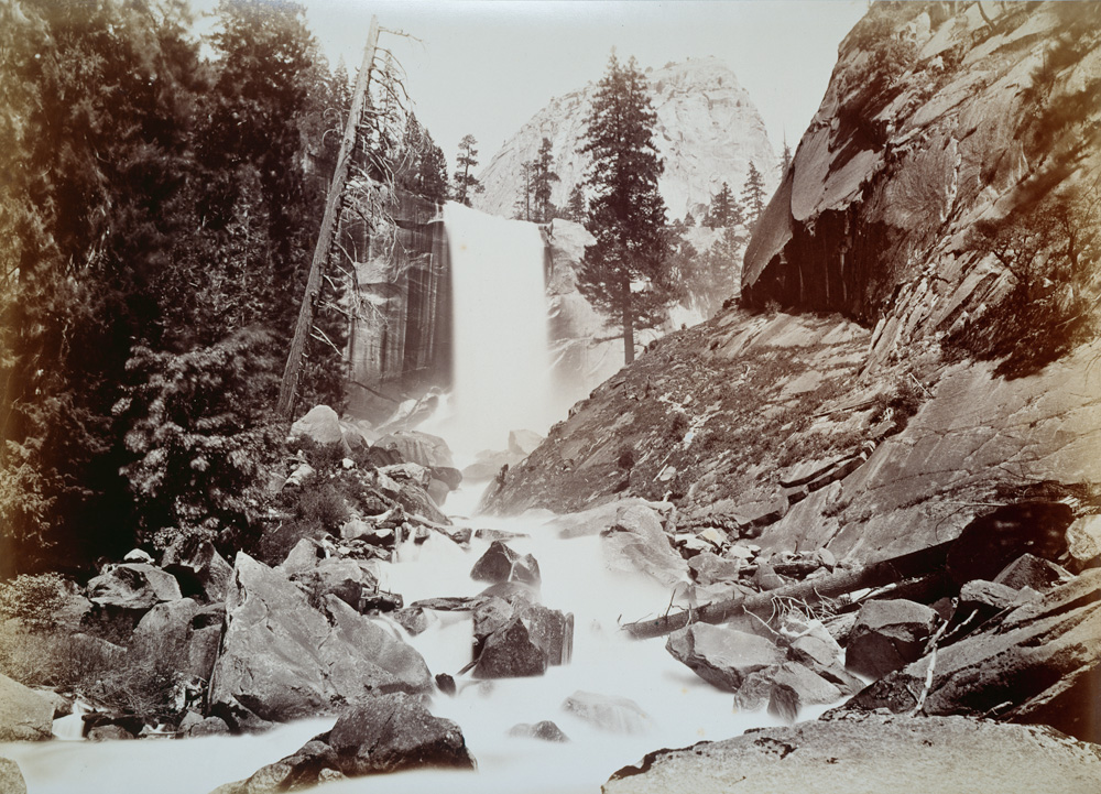
Two falls reward hikers who climb out of the valley along the Merced River. Vernal Fall is a broad, powerful block of water about 317 feet high, reached on the famous Mist Trail — roughly 2.6 miles round trip to the top, with granite steps that earn the trail its name when the spray is heavy. Continue past it and you reach Nevada Fall, a steep, horsetail-shaped drop of about 594 feet, around 5.4 miles round trip. Both are at their thundering best in late spring, May into June, and unlike the creek-fed falls they keep meaningful flow deeper into summer because the Merced drains a large high-country watershed.
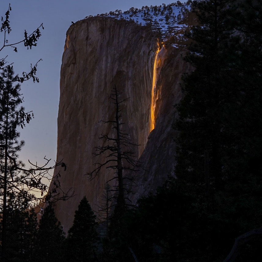
Then there is Horsetail Fall, which is famous less for its water than for two February weeks of light. This thin, roughly 1,570-foot ribbon on the east face of El Capitan flows only seasonally, and in mid-to-late February — when there is enough water, the sky is clear, and the setting sun strikes it at exactly the right angle — it lights up molten orange in the so-called 'firefall' effect. All three conditions have to align, and a single passing cloud in the final minutes before sunset can cancel the show. It is a short walk of about a mile and a half from the nearest parking, but the event draws large crowds, so check the park's current-year viewing and access guidance before planning around it.
The reliable falls of the north: Burney and Mossbrae
If the Yosemite falls are a spring gamble, northern California offers two falls that run no matter the season — because they are fed by springs rather than snowmelt. McArthur-Burney Falls, on Burney Creek near the town of Burney in Shasta County, is the standout. At 129 feet it is far from the tallest fall in the state, but its character is unique: groundwater emerges from porous volcanic rock at and above the lip, so water pours not just over the top but straight out of the mossy cliff face in dozens of strands. The result is a remarkably constant flow estimated at roughly 100 million gallons a day, even in the dry heat of late summer. Theodore Roosevelt reportedly called it 'the Eighth Wonder of the World,' and it was named a National Natural Landmark in 1954.
Burney Falls sits inside McArthur-Burney Falls Memorial State Park, which means real infrastructure: parking, a visitor center, and an easy loop trail of roughly 1.3 miles that takes you from the overlook down to the base and back. Because it does not depend on snow, it is a genuine year-round destination — a rarity on this list and a good anchor for a trip to the volcanic Lassen and Shasta country.
Mossbrae Falls, on the upper Sacramento River near Dunsmuir, is the north's beautiful problem child. It is another spring-fed fall — water seeps out of moss-covered rock and spreads in a wide, delicate curtain commonly documented at around 50 feet tall (sources vary, and the figure reflects the broad cascade rather than a single clean plunge). It runs year-round and is genuinely lovely. But there is currently no legal public route to it: the long-used approach follows roughly a mile-plus of active Union Pacific railroad track, which is trespassing and has proven dangerous, with people struck by trains in recent years. A long-discussed legal trailhead and pedestrian bridge would change that, but until it exists, we list Mossbrae for completeness and recommend against the railroad walk. Treat it as a fall to admire from the record books, not a hike to attempt.
California's coastal tidefalls: McWay and Alamere
California has one of the rarest waterfall types in the country: the tidefall, a fall that drops directly onto a beach or into the ocean. There are only a handful in the United States, and two of the best are here. McWay Falls, in Julia Pfeiffer Burns State Park on the Big Sur coast, is the postcard — an 80-foot plunge of McWay Creek onto a cove of pale sand framed by turquoise water. A 1983 landslide deposited the sand that built today's beach, so the fall now reaches the surf only at high tide rather than dropping straight into open ocean, but it remains one of the most photographed natural scenes on the West Coast. It flows year-round.
Reaching the McWay viewpoint is normally a short, easy walk of well under a mile from the Highway 1 parking area — but access has been affected by trail and retaining-wall work along the Big Sur coast in recent years, with closures extending into 2026, so confirm the current status with California State Parks before you go. The beach itself and the cliffs around the fall are off-limits to protect the cove; the experience is a clifftop overlook, not a walk to the base.
Alamere Falls, in Point Reyes National Seashore north of San Francisco, is the wilder cousin. This roughly 40-foot tiered tidefall pours over a bluff onto the south end of Wildcat Beach and is one of the very few true ocean-meeting tidefalls in the country. Earning it is the point: the shortest sensible route from the Palomarin trailhead runs about 13 miles round trip through the Phillip Burton Wilderness, and the final beach approach can be impassable at high tide or high surf. Check the tide tables and any surf advisories before committing, time your arrival for low tide, and start early — the trailhead parking fills on weekends and in summer. It runs best from the wet season into spring, roughly December through April.
Day-hike falls and a high-country bonus
Not every great California fall demands a national park or a wilderness trek. Eaton Canyon Falls, tucked into the San Gabriel Mountains above Altadena in the Eaton Canyon Natural Area near the Angeles National Forest, is the classic Los Angeles-area waterfall hike — a 40-foot plunge reached by a roughly 3.5-mile round-trip walk up a boulder-strewn canyon. It is most worth it in winter and spring after rains, from about January through April, when the creek is actually running; in a dry late summer the fall can be thin or dry. Its proximity to the city makes it popular and, at times, hazardous when people scramble off-trail above the falls, so stick to the canyon-bottom route.
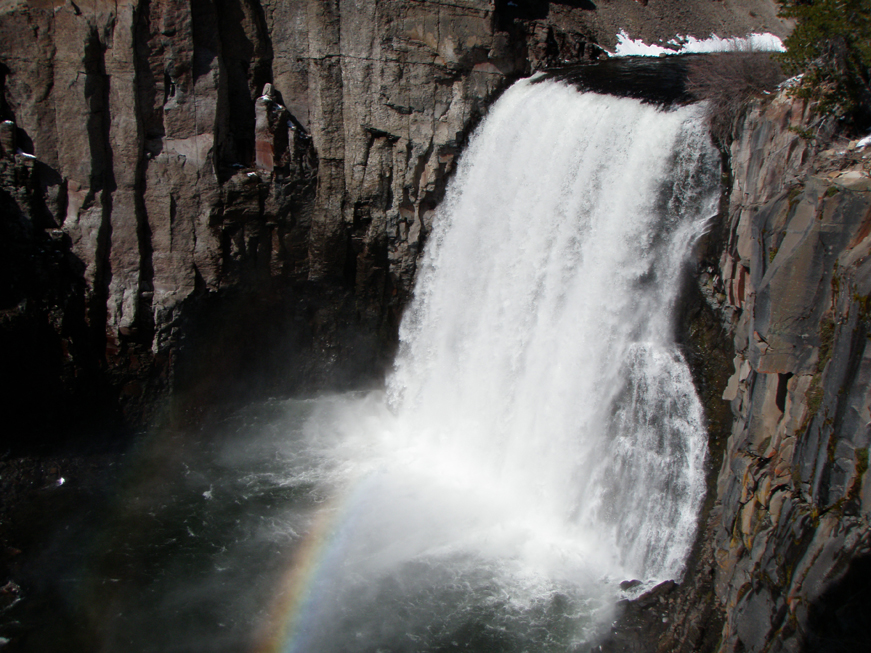
For a high-country bonus with a completely different feel, Rainbow Falls in Devils Postpile National Monument near Mammoth Lakes is a 101-foot plunge of the Middle Fork San Joaquin River. Unlike the spring falls, this one peaks in summer — roughly July through September — once the high Sierra has melted out and the access road and shuttle are open. It is named for the rainbows that form in its midday mist, and it sits a short walk beyond the monument's famous columnar-basalt formation. Reaching it is about a 5-mile round-trip hike from the typical trailheads, making it a satisfying half-day on a Mammoth trip.
Taken together, these eleven falls cover the range of what California offers: the sheer scale of Yosemite, the year-round dependability of the spring-fed north, the rare beauty of the coast's tidefalls, and the accessible canyon falls near the cities. Pick by season as much as by scenery — a Yosemite giant in April, Burney any month, a coastal tidefall in winter, Rainbow Falls in high summer — and you can chase good water somewhere in the state nearly all year.