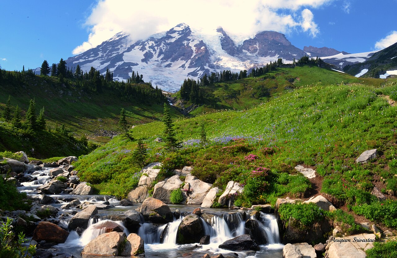
Why Mount Rainier Is a Waterfall Park
Mount Rainier is a 14,410-foot glaciated volcano, and almost every waterfall in the park owes its existence to that ice. Meltwater from the mountain's glaciers and permanent snowfields feeds creeks that tumble off lava cliffs, carve narrow andesite gorges, and drop hundreds of feet in a single reach. The result is an unusually dense collection of waterfalls for one park — and a wide spread of access, from falls you can photograph a few steps from your car to 300-plus-foot cascades that take a half-day hike to reach.
Because the water comes from glaciers and lingering snow, timing matters. Many of the park's falls run hardest during late spring and early summer snowmelt, then settle into a steadier flow through August and September. The trade-off is access: the high-country trailheads at Paradise, the Comet Falls trailhead on the road to Paradise, and the Mowich Lake area generally don't melt out and reliably open until mid-summer. The window where both the water and the trails cooperate is roughly July through early October, with the shoulder weeks offering the best balance of flow, wildflowers, and clear roads.
This guide covers six of the park's signature falls, ordered from the tallest hike-in cascades down to the short roadside stops. For each, you'll find the watercourse it sits on, a reported height (with the caveat that published heights vary by source and measurement method), and the trail distance, difficulty, and best season to plan around. All six sit inside Mount Rainier National Park and are managed by the National Park Service, so the standard park entrance fee and seasonal road schedule apply.
The Tall Hike-In Falls: Spray and Comet
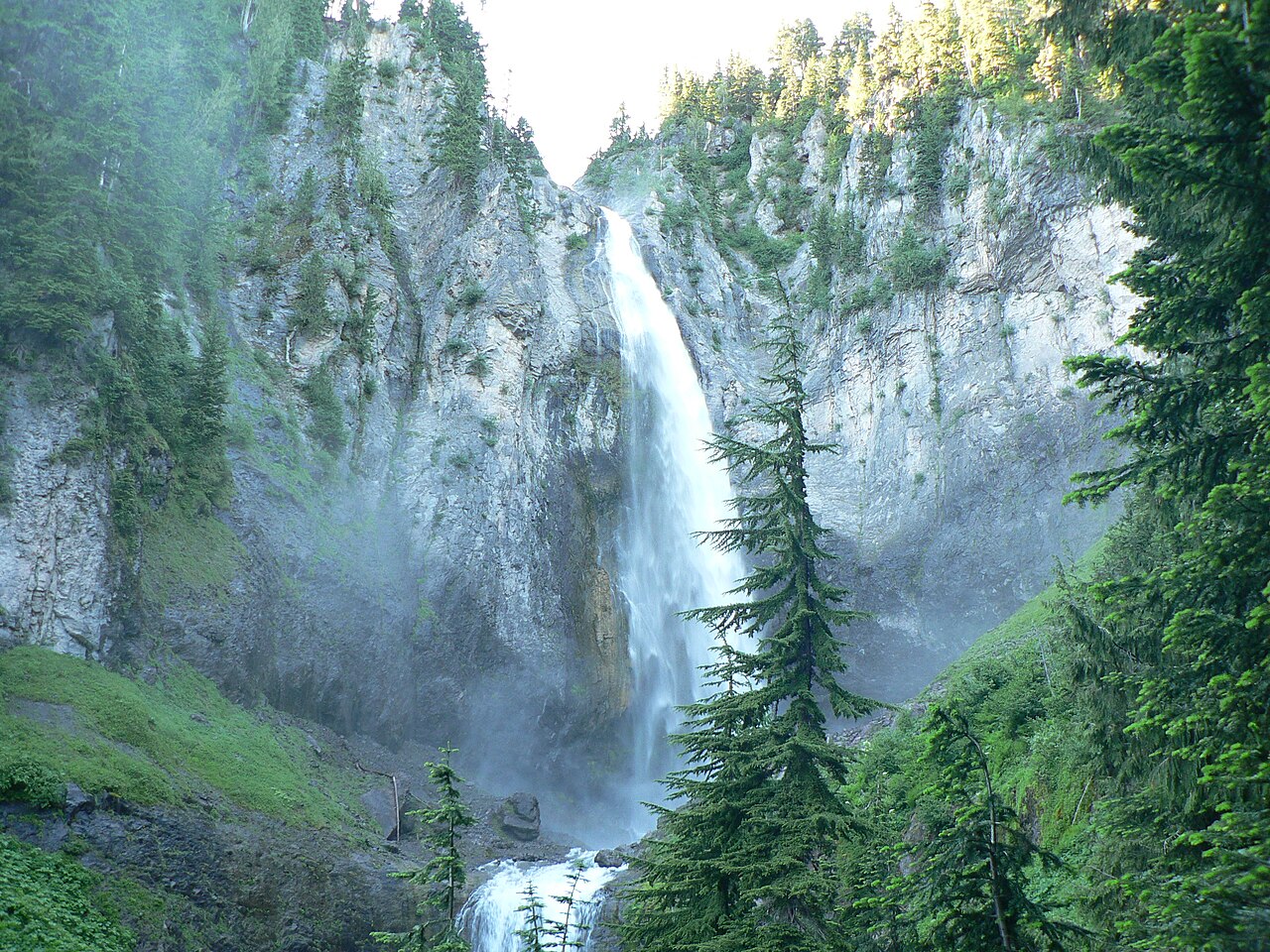
Spray Falls is the tallest waterfall in this guide, reported at roughly 354 feet, where Spray Creek — fed by the remains of the Flett Glacier — fans out over a broad face of reddish andesite. It's a fan-type falls, spreading wide rather than plunging in a single column, and it's one of the more dramatic payoffs in the park's quieter northwest corner. You reach it from the Spray Park Trail, which starts at the southeast side of the Mowich Lake walk-in campground at the end of Mowich Lake Road. The hike runs about 4 miles round trip with a modest 545 feet of elevation gain over rolling terrain — moderate, not brutal, with a short spur dropping down to the falls' base. Plan on roughly three hours.
Timing for Spray Falls is the catch. The Mowich Lake area is one of the last parts of the park to open, typically mid-July through mid-October, and access via SR 165 has been affected by a bridge closure in recent seasons — check current conditions with the park before you commit to the drive. The nearest gateway community is Wilkeson, on the northwest approach. If you can get there in late summer, you can continue another mile and a steep climb past the falls into the wildflower meadows of Spray Park, making it one of the best combined waterfall-and-meadow days in the park.
Comet Falls, at a reported 320 feet on Van Trump Creek, is the more famous of the park's tall hike-in falls and the one most day hikers chase. It drops in a long, narrow tiered ribbon — the kind of falls that looks like a white streak against dark rock from a distance. The National Park Service lists the route as 3.8 miles round trip from the Comet Falls trailhead, which sits about four miles east of Longmire on the road to Paradise. Note that published numbers vary: the NPS page cites roughly 900 feet of gain, while popular trail apps list figures closer to 1,200–1,280 feet, so treat this as a genuinely strenuous climb regardless of which number you trust.
The Comet Falls trailhead has very limited parking that fills early on summer weekends — arrive at dawn or plan a weekday. The trail follows Van Trump Creek up a rocky, forested valley and passes the smaller Christine and Van Trump cascades on the way up. Best season is summer, July through September, once the upper trail is reliably snow-free; early-season hikers can hit lingering snowfields on the steeper upper switchbacks. Ashford, just outside the Nisqually Entrance, is the nearest town for lodging and a pre-hike breakfast.
The Short-Hike Falls: Narada and Myrtle
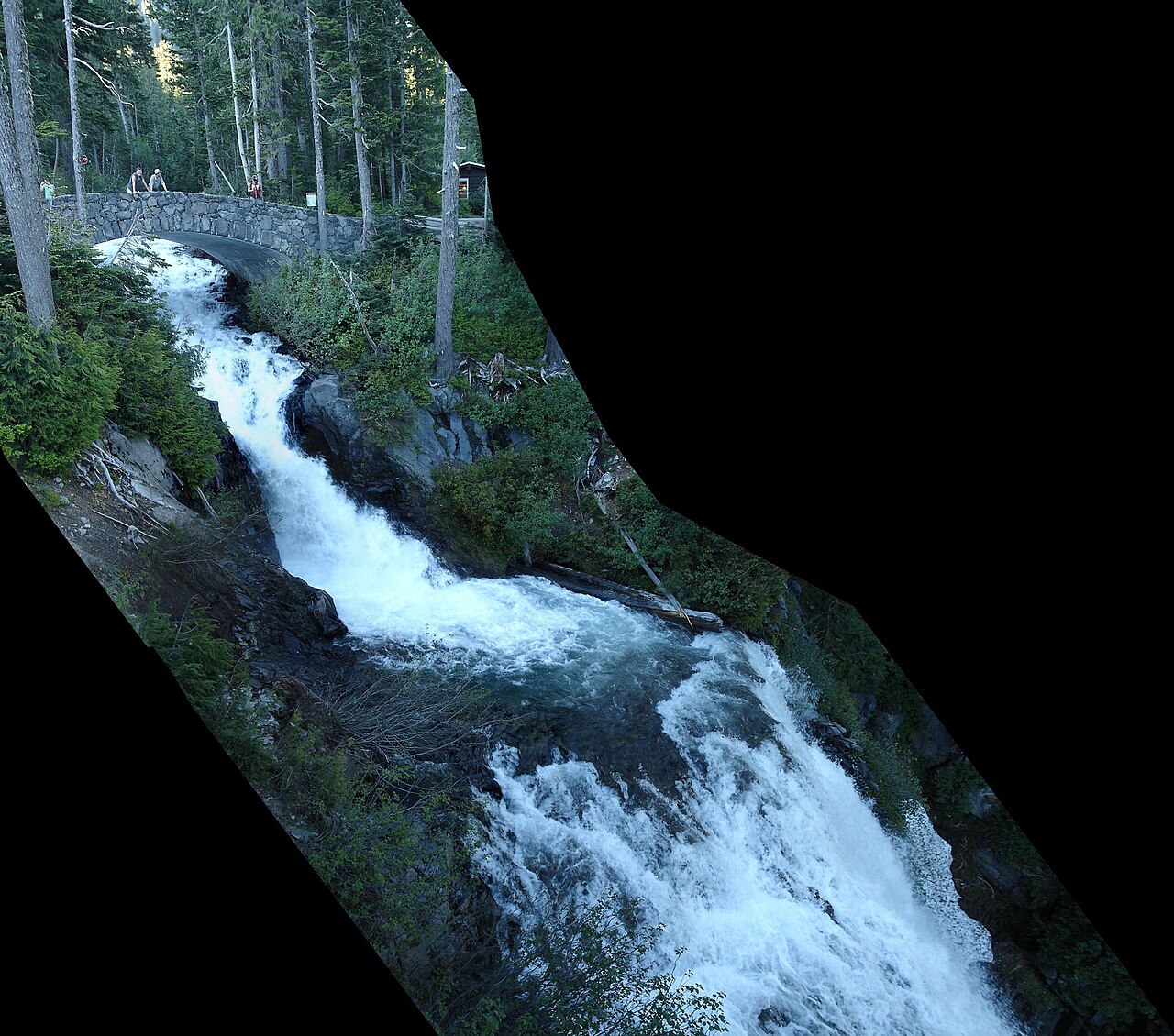
Narada Falls is the showstopper of the park's short-hike falls. The Paradise River drops a reported 188 feet here in two tiers — a roughly 168-foot upper horsetail and a shorter lower step of about 20 feet — spreading some 50 feet wide across a sheer andesite cliff. On a high-snowmelt day in late spring or early summer, the volume is loud and the spray drifts across the viewpoint trail. From the Narada Falls parking area on the road between Longmire and Paradise, a short, steep, and almost-always-wet path drops to the lower viewpoint in about 0.2 to 0.4 mile; the trail connects onward to the Wonderland Trail and loop options toward Reflection Lakes.
Because that viewpoint trail is short, steep, and perpetually slick from ground seepage, treat it as easy in distance but watch your footing — the mist keeps the rock and railings wet through the season. Narada peaks with the snowmelt, so late spring into early summer is the highest-volume window, though it runs all season. Ashford is the nearest gateway town outside the Nisqually Entrance.
Myrtle Falls is the most photogenic easy walk in the park, and arguably the most photographed view at Rainier. The falls themselves are a 72-foot horsetail on Edith Creek, but the reason people go is the framing: from the overlook, you can line up the falls with the summit of Mount Rainier rising directly behind it — one of the few spots in the park where you get the mountain and a waterfall in a single frame. It sits just 0.4 mile from Paradise Inn along the paved start of the Skyline Trail, an easy, mostly gentle walk suitable for most visitors.
Myrtle's catch is snow. Paradise is high country — the falls overlook sits around 5,600 feet — so the trail is snowbound well into summer and the reliable window runs mid-July through September, when the meadow path is clear and the surrounding wildflowers are out. Even though Edith Creek flows year-round, you won't comfortably reach the overlook outside the snow-free months. Combine it with the full Skyline Loop for one of the park's best high-country day hikes.
The Roadside Stops: Christine and Silver Falls
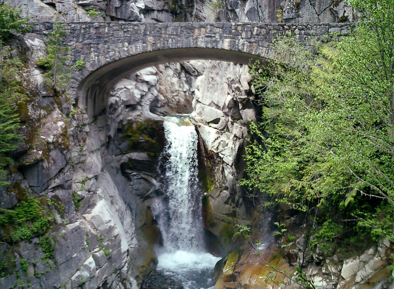
Christine Falls is the classic Rainier roadside photograph. The falls — reported in the neighborhood of 60 to 69 feet — drop on Van Trump Creek, the same creek that feeds Comet Falls higher up, and the signature shot frames the lower tier through the graceful stone arch of the historic Christine Falls Bridge. The waterfall is named for Christine Van Trump, daughter of P.B. Van Trump, one of the first recorded climbers of Mount Rainier. From the small pullout, it's a walk of only a couple hundred feet — about 0.1 mile — down a short path to the overlook below the bridge, which gives the best composition. This is the easiest stop in the guide: roadside, quick, and family-friendly. Flow is strongest in late spring and early summer with the snowmelt, and Ashford is the nearest town.
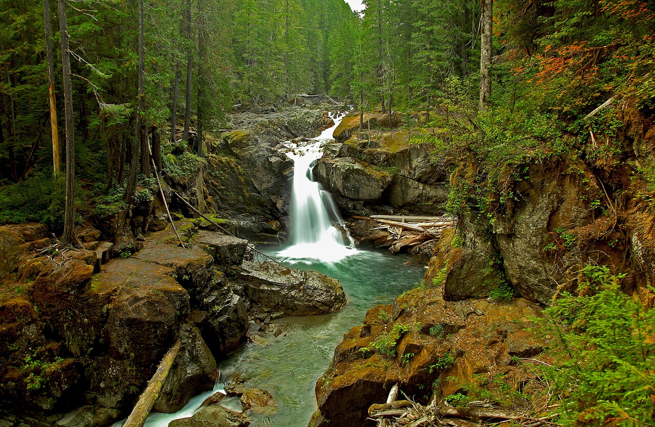
Silver Falls sits in the park's quieter southeast corner, where the Ohanapecosh River pours roughly 60 to 70 feet through a forested gorge of mossy old growth. It's a cascade-type falls — more a powerful, churning chute than a clean vertical plunge — and the surrounding ancient forest makes the walk as much of a draw as the water. The classic route is the Silver Falls Loop, about 3 miles with around 300 feet of elevation gain, traditionally starting near the Ohanapecosh Visitor Center off Route 123. Shorter access points exist too: a roughly 0.6-mile spur from Route 123 reaches the falls in about 45 minutes one way.
One important planning note for 2026: the Ohanapecosh Campground has been closed for construction, which has affected the standard loop. During the work, hikers have been routed to Silver Falls via the Eastside Trail and the loop can't be completed in the usual way — construction has been expected to last through summer 2026, so check current park conditions before planning your route. Silver Falls runs reliably from late spring through fall, and Packwood, southeast of the park, is the nearest gateway town for this corner.
Both of these are the falls to chain together when you don't have a full hiking day — Christine on the southwest road to Paradise, Silver in the southeast near Ohanapecosh — and they bracket the park's two most popular driving corridors.
Ranking, Mapping, and How to Plan a Day
Ranked purely by reported height, the order runs Spray Falls (~354 ft) and Comet Falls (~320 ft) at the top, Narada Falls (~188 ft) in the middle, then Myrtle Falls (~72 ft), Christine Falls (~60–69 ft), and Silver Falls (~60–70 ft) rounding out the group. But height isn't the only way to rank a waterfall day. By effort, the falls split cleanly into three tiers: roadside (Christine), short hikes under a mile (Narada, Myrtle, and the short approach to Silver), and half-day hikes (Comet at 3.8 miles strenuous, Spray at ~4 miles moderate). A reasonable rule of thumb: pick one big hike-in falls, then stack two or three roadside and short-hike stops around it.
Geographically, the falls cluster along the park's main corridors. The Nisqually-to-Paradise road on the southwest side strings together Christine Falls, the Comet Falls trailhead, Narada Falls, and Myrtle Falls at Paradise — you can see four of the six in a single day without ever leaving that one road, hiking only the ones you have energy for. Silver Falls sits on the opposite, southeast side near Ohanapecosh off Route 123, and Spray Falls is off on its own in the northwest at the end of Mowich Lake Road. Trying to combine Spray or Silver with the Paradise-corridor falls means a lot of driving, so plan them as separate days or separate trips.
For most visitors, the highest-value single day is the Paradise corridor in late summer: stop at Christine Falls (0.1 mile, roadside), grab the Comet Falls hike if you want the big effort (3.8 miles, strenuous), pull off at Narada Falls (short and steep), and finish with the easy walk to Myrtle Falls at Paradise for the iconic mountain-and-falls photo. That sequence covers the park's range — a tall hike-in cascade, a tiered roadside giant, and the most famous view — in one corridor.
Whichever falls you target, build your plan around two variables: when the trail melts out and when the water runs hardest. Snowmelt-fed falls like Narada and Christine peak in late spring, but the high trailheads at Paradise and Mowich often don't open until mid-July. Always confirm current road and trail status, parking, and any construction closures with the National Park Service before you go — conditions on this mountain change fast, and several of these access points have been affected by recent closures.