How to read this guide (and a note on heights)
Montana is a waterfall state in the way few people expect. The big names belong to Glacier National Park, where snowmelt pours off hanging valleys and tumbles beside the Going-to-the-Sun Road, but the falls worth a detour are spread across the whole western half of the state — down the Seeley-Swan corridor, into Hyalite Canyon above Bozeman, out to the Kootenai River near the Idaho line, and right into the middle of the city of Great Falls. This is a curated selection, not a complete inventory. Montana has hundreds of named drops in the USGS Geographic Names database and many more unnamed cascades on creeks that only run hard for a few weeks in spring; what follows are thirteen documented falls chosen because they are reliably reachable, genuinely worth the trip, and well enough recorded that we can describe them honestly.
A word about the numbers first, because waterfall heights in Montana are slipperier than they look. A reported height depends entirely on how it was measured: the tallest single uninterrupted drop, the cumulative fall down a long cascade, or someone's eyeball estimate from a turnout two miles away. Bird Woman Falls is the clearest example — the National Park Service describes a roughly 492-foot drop, while the World Waterfall Database catalogs a much larger cumulative figure that includes the upper tier and all the connecting cascades. Both can be 'correct' for what they measure. Where a height is given in this guide, treat it as a reasonable documented figure, not a surveyed certainty, and assume the real answer is 'tall enough to be impressive.'
We have grouped the falls by the kind of trip they make, not by a strict ranking. Glacier's showpieces come first because they are the reason most people chase waterfalls in Montana at all. Then the Great Falls of the Missouri, which are a piece of national history as much as a waterfall. Then the Bozeman and Big Sky cluster, which gives the southwest its own easy day-hikes. And finally the falls of the west and the Seeley-Swan, the quiet ones that reward a longer drive. Trail distances and seasons below are drawn from agency and trail sources; in Glacier especially, what is open depends heavily on the calendar.
Glacier National Park: the showpieces
If you only see Montana waterfalls in one place, see them in Glacier. Bird Woman Falls is the headliner and the easiest to reach in the most literal sense — you do not hike to it at all. It hangs in a high cirque between Mount Oberlin and Mount Cannon and is visible from turnouts along the Going-to-the-Sun Road, roughly two miles away across the valley. The Park Service describes a drop of around 492 feet (our data lists 560, and the World Waterfall Database catalogs a much larger cumulative figure including the upper cascades). However you count it, this is a tall horsetail fed by snowfields and a remnant glacier, which means it is a spring-and-early-summer show: flow is greatest with the late-spring melt in June and July and can dwindle to almost nothing by autumn. Because it sits high on the alpine section of the Going-to-the-Sun Road, you can only see it once that road has plowed open, typically not until late June or July.
For falls you actually walk to, the St. Mary and Virginia Falls pairing on the park's east side is the classic outing. From the St. Mary Falls shuttle stop it is a short walk — under a mile each way — down to St. Mary Falls, a clear, blue-green tiered drop of about 35 feet just above St. Mary Lake. Continue upstream and the trail climbs to Virginia Falls, a taller tiered fall around 50 feet that many hikers rate the best on this side of Logan Pass. Done as a loop or out-and-back from the shuttle, the full trip runs roughly 2.4 to 3.6 miles depending on where you start and how far up the Virginia Creek cascades you push. Both are summer hikes — figure late June through September — and using the free park shuttle from the St. Mary Visitor Center sidesteps the brutal parking competition at the trailhead.
Over in the Two Medicine area, Running Eagle Falls earns its other name, 'Trick Falls,' honestly. It is a short, paved, wheelchair-accessible path of about 0.6 miles round trip off the Two Medicine Road, and what you see depends entirely on the season. During the spring snowmelt of May and June, water charges over the upper ledge in a roughly 40-foot drop that hides the lower falls behind it; by late summer the upper falls thins to a trickle and the water instead bursts out of a cave-like opening at the base, revealing the lower fall. It is the rare waterfall that is worth visiting twice in one summer to watch it change. Note that the Two Medicine Road itself is a seasonal road, generally open only from late May into mid-October.
The Great Falls of the Missouri: history you can stand beside
The Great Falls of the Missouri are not one waterfall but five, strung along a ten-mile reach of the Missouri River through the city that took their name. When the Lewis and Clark Expedition reached them in 1805, the falls forced a brutal eighteen-mile portage that cost the party nearly a month, and Meriwether Lewis called the sight the grandest he had beheld on the journey to that point. That history is the real reason to come: this is one of the most consequential natural obstacles in the story of the American West, and you can stand on the bank where it happened.
It is also a waterfall that has been heavily reshaped by people, and an honest guide has to say so. Beginning in the late 1800s, a series of hydroelectric dams was built on the falls; the Great Falls itself — the largest of the five, at a documented height of around 87 feet — is now the site of Ryan Dam, completed in 1915, whose powerhouse occupies much of the original drop. Several of the other falls were submerged or altered, and Crooked Falls is generally cited as the only one of the five remaining in something close to its natural state. What you see today at Ryan Dam Park is a dam-controlled curtain of water rather than the wild cataract Lewis described, and because the flow is managed for power generation it varies day to day rather than following a clean seasonal curve. It is reached by a very short walk of a few hundred yards from the parking area.
Rainbow Falls, a few miles upstream and also on the Missouri within Great Falls, is the easiest companion stop — a block fall of roughly 47 feet visible from the riverside near an overlook, with no hike required. Like the Great Falls proper it sits below a dam and shows best in spring high water. Taken together, the Great Falls and Rainbow Falls make a flat, roadside, deeply historical morning that asks almost nothing of your legs and a fair amount of your imagination.
Bozeman and Big Sky: the southwest day-hikes
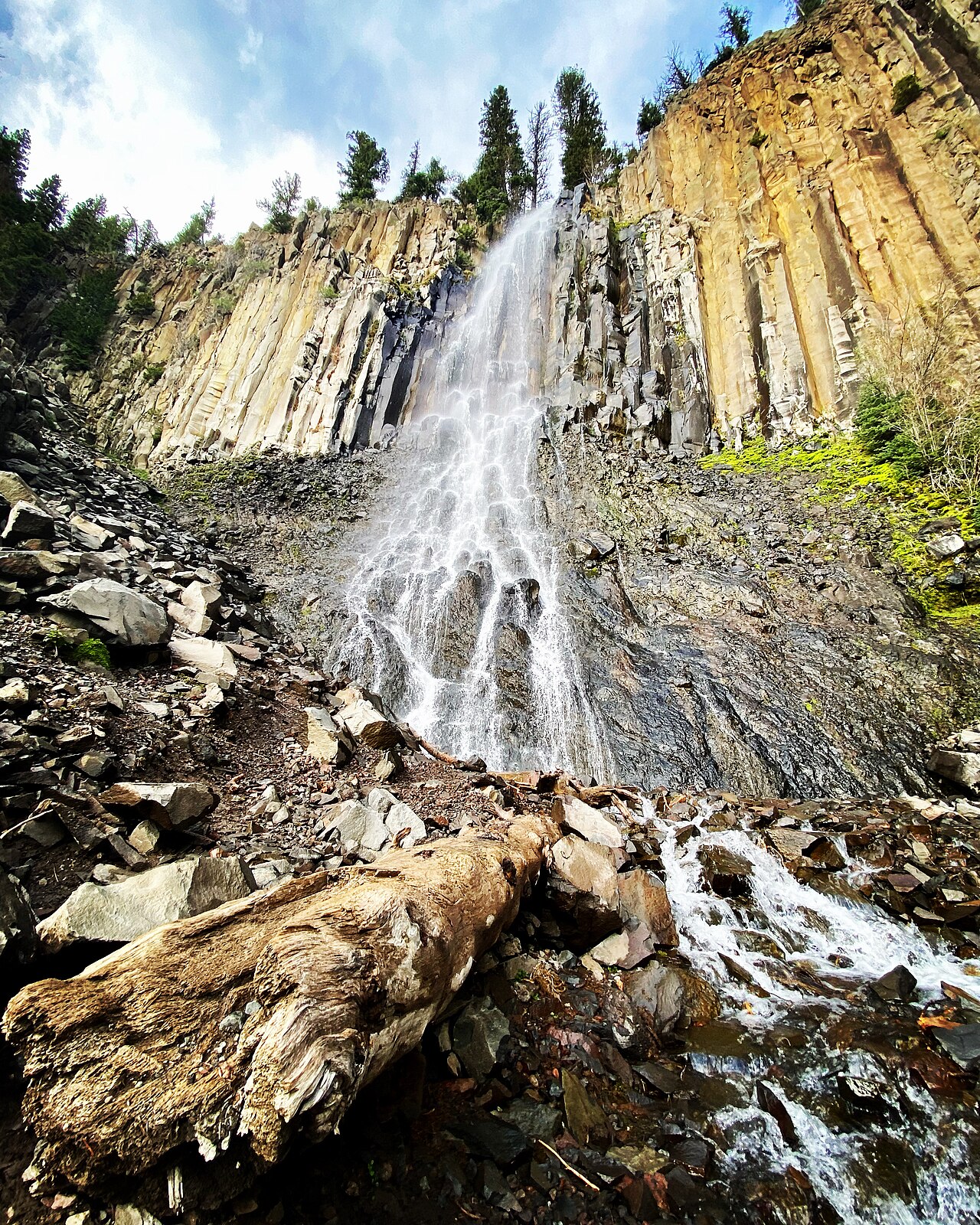
Southwest Montana gives you waterfalls without a national-park entrance fee or a wilderness permit. The standout is Palisade Falls in Hyalite Canyon, just south of Bozeman in the Custer Gallatin National Forest. An 80-foot horsetail, it pours down a vertical wall of columnar basalt — hexagonal volcanic columns formed as molten rock cooled and contracted — and the trail to its base is paved and accessible, climbing gently over a short distance (our data lists about 1.2 miles round trip). It is the rare combination of a dramatic, geologically interesting fall and a path that families, casual walkers, and photographers can all manage. The catch is access: the upper Hyalite road past the reservoir is gated through winter, typically closing around the start of January and reopening around mid-May, so plan for a late-spring-through-fall visit.
Deeper into the same drainage, Champagne Falls is the reward for a real hike. It sits along Hyalite Creek on a trail that strings together a remarkable run of waterfalls, with Champagne — a roughly 80-foot plunge — among the highlights at around 7.4 miles round trip and a moderate grade. This is a summer-into-early-fall outing best attempted once the high water of early melt has settled and the trail has dried out; come for the falls, stay for the half-dozen others you pass on the way up the canyon.
For the gentlest option in the region, Ousel Falls sits in a community park just outside Big Sky, on the South Fork of the West Fork of the Gallatin River. The trail is a well-built, family-friendly path of about 1.6 miles round trip that descends to a tiered fall of roughly 50 feet. Because it is managed by the Big Sky Community Organization rather than a federal agency, it has the feel of a town park — maintained, signed, and busy on summer weekends — and it runs from spring through fall. Closer to Livingston, Pine Creek Falls in the Absaroka Range is the other classic short hike: a cascade on Pine Creek reached by a moderate trail of about 2.5 miles round trip through the Custer Gallatin National Forest, best in summer, and a common warm-up for hikers headed deeper toward Pine Creek Lake.
The west and the Seeley-Swan: the quiet drives
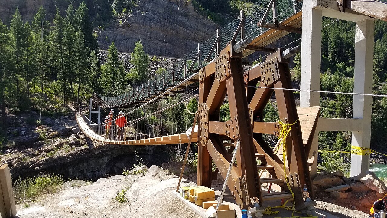
Out in the state's northwest corner, Kootenai Falls is the most powerful waterfall most Montanans have never made time to see. On the Kootenai River just off U.S. Route 2 between Libby and Troy, it is the largest undammed falls in Montana and one of the higher-volume waterfalls in the country — the river drops roughly 90 feet over a series of ledges in less than a mile, with the main visible plunge nearer 30 feet. A short but rocky trail of about 1.5 miles round trip leads down to the river, where a famous swinging footbridge, originally built by the Civilian Conservation Corps in the 1930s and rebuilt as recently as 2019, crosses high above the water. The site is sacred to the Kootenai people, and it shows best in late spring and summer when the river is running full. Treat the rock near the water with respect; it is slick and the current is enormous.
The Seeley-Swan valley, on the highway between Missoula and the Flathead, hides two of Montana's best forest-walk falls. Morrell Falls, near Seeley Lake in the Lolo National Forest, is a tiered drop of about 90 feet at the end of a gentle, well-graded trail of roughly 5.5 miles round trip — long but genuinely easy, which makes it a favorite for families willing to put in the distance. It runs from about June through September, after the snow clears the trail. Farther north near Condon, Holland Falls in the Flathead National Forest is the shorter, steeper sibling: a cascade of around 40 feet reached by a moderate trail of about 3 miles round trip along the shore of Holland Lake, with the falls and the lake views together making the climb worth it. Like Morrell, it is a June-through-September hike.
What ties these quieter falls together is the trade-off they offer: a longer drive and, in a couple of cases, a longer walk, in exchange for far smaller crowds than Glacier or Hyalite. Taken across the whole guide, these thirteen falls cover the full range of what Montana does — the alpine drama of Glacier, the dam-bound history of the Missouri, the accessible basalt of Hyalite, and the deep-forest cascades of the west. None of them is the single 'best' waterfall in the state; together they are a fair map of why Montana is worth chasing falls in at all.