How to Read This List (and Why It's a Curated Selection)
Alabama is not the first state most people picture when they think waterfalls, but the northern third of it — where the southern tail of the Appalachians breaks up into Lookout Mountain, the Cumberland Plateau, and the Talladega highlands — hides hundreds of them. The William B. Bankhead National Forest alone is nicknamed the 'Land of a Thousand Waterfalls.' What follows is not that thousand. It is a deliberately short, curated set of twelve documented falls chosen because each one is genuinely worth a trip, has a known land manager, and is reachable by an ordinary visitor without a permit or a rope.
We have ordered them loosely from tallest to shortest, because height is the single fact most people search for first. That ordering is a convenience, not a ranking of quality — a 15-foot cascade you can swim under can easily beat a 130-foot ribbon that only runs three months a year. We say so where it applies. Every height, trail distance, and land manager below comes from the public record (National Park Service, U.S. Forest Service, Alabama State Parks, and waterfall databases), and where sources disagree we flag the disagreement rather than pretend to a precision the data doesn't support.
One honest caveat that governs almost every entry: in Alabama, water is seasonal. The Cumberland Plateau falls are rain-fed and plateau-drained, which means they roar from late winter through early spring and can dwindle to a trickle — or vanish entirely — by August. If a waterfall's height is the headline, its season is the fine print, and we treat the season as a first-class fact throughout.
The Tall Ones: Grace's High Falls, DeSoto Falls, and Noccalula Falls
Grace's High Falls, near Fort Payne in Little River Canyon National Preserve, is the tallest documented waterfall in Alabama at roughly 133 feet. It is a horsetail drop on Bear Creek, a tributary that feeds the Little River, and it is gloriously low-effort to see: you view it across the gorge from a marked pullout on the Little River Canyon Rim Parkway, no hike required. The catch is flow. Grace's is fed by a small plateau drainage, so it is a winter-and-spring waterfall and is frequently bone-dry by summer. Time your visit for a day or two after heavy rain between December and April and you'll understand why it tops the list; show up in August and you may find a stained cliff and nothing falling.
DeSoto Falls, just up the road near Mentone inside DeSoto State Park, is the one to see when you want height with reliable presence. It plunges about 104 feet on the West Fork of the Little River — sources put the drop anywhere from 104 to 107 feet depending on where they measure top and bottom — into a small canyon it has carved for itself above an old dam. The walk to the overlook is short and easy, a few hundred feet down a set of concrete steps, which makes this arguably the best effort-to-payoff ratio of any tall falls in the state. Like its neighbors it runs hardest in winter and early spring; by late summer it thins considerably, though it rarely disappears entirely the way Grace's does.
Noccalula Falls, in the city of Gadsden, is the most developed and most storied of the tall three. Black Creek drops about 90 feet over a sandstone lip into Black Creek Gorge, and the falls anchor a 225-acre municipal park run by the City of Gadsden. A bronze statue of 'Noccalula' — a mythic Cherokee figure tied to a legend of the falls that dates to the late 1700s — stands at the brink, and a gorge trail of roughly a mile and a half leads down past the base and along the creek. Because it is city-managed and partly augmented, Noccalula is a dependable, family-friendly stop, but the natural flow still follows Alabama's rainfall: best in the wet winter and spring months.
The Showpieces: Peavine, Little River Falls, and High Falls
Peavine Falls is the marquee waterfall of the Birmingham metro. Inside Oak Mountain State Park near Pelham, this roughly 65-foot, spring-fed cascade on Peavine Branch is the park's single most-visited feature. Reaching the base is a short but real hike — figure about a mile and a half on the Green-and-White trail system from the Peavine Falls parking lot, with a rocky scramble down into the gorge near the end, which is why we rate it moderate rather than easy. Because the upper portion is rain-dependent, the falls can drop to a thin ribbon in dry spells; go after a good rain in winter or spring and the rock face fills out properly.
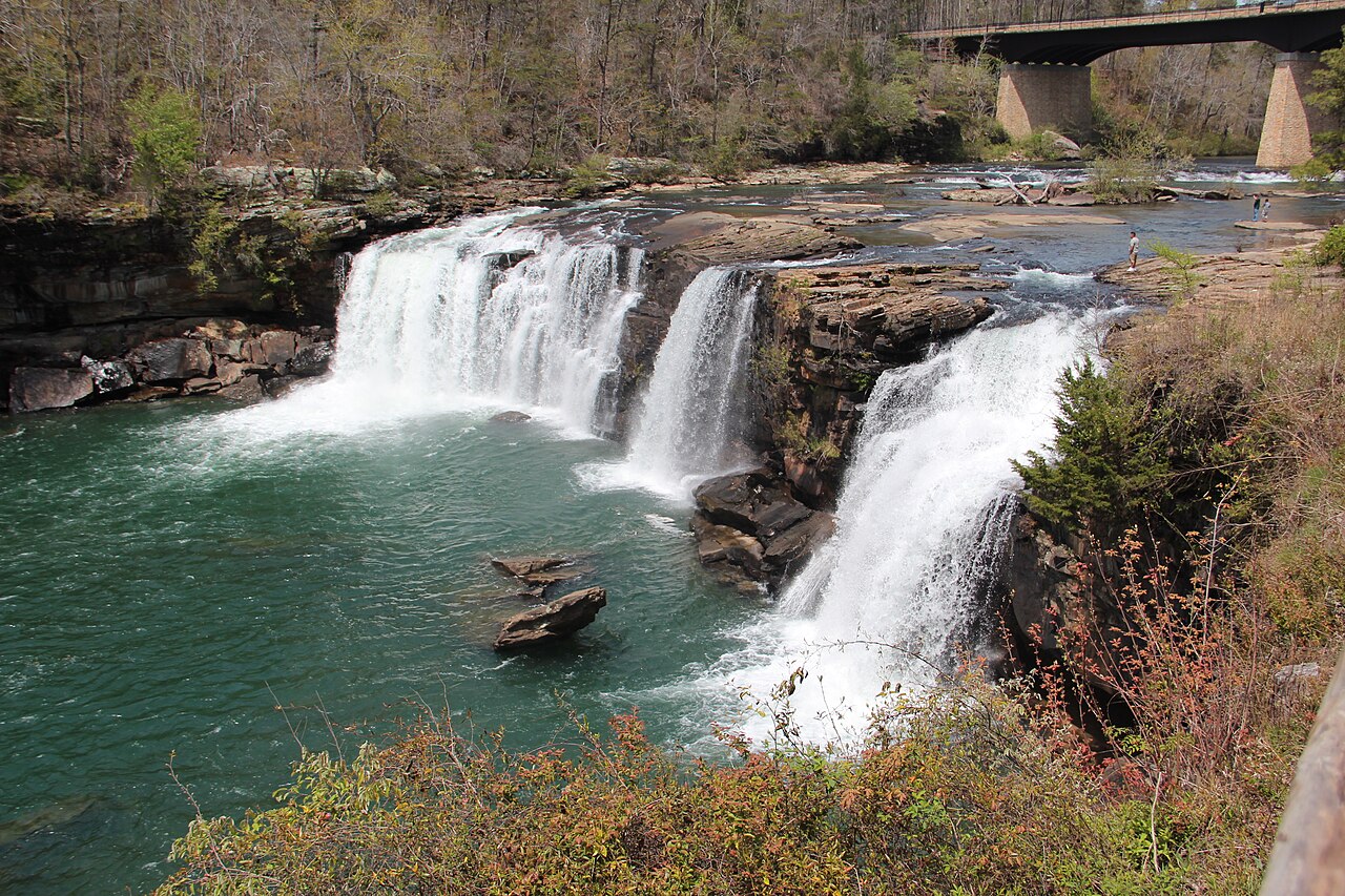
Little River Falls, back in Little River Canyon National Preserve near Fort Payne, is shorter than the canyon's namesake giants at about 45 feet, but it punches well above its height. It is a wide block falls on the Little River itself, and it is frequently cited as one of the largest-volume waterfalls in any national park unit on the U.S. East Coast. An ADA-accessible boardwalk of roughly a tenth of a mile drops you to a close view, making this the most wheelchair-friendly major falls in the state. In high winter and spring flow it is a wall of whitewater; by midsummer the river drops enough that people swim in the pools below.
High Falls, in DeKalb County's High Falls Park near Geraldine, is the entry that proves height isn't everything. On Town Creek it is only about 35 feet tall, but it spreads roughly 300 feet wide — one of the broadest waterfalls in the South — and the creek has eroded a natural rock arch beside the main drop that is a draw in its own right. The county-managed park keeps the short walk to the falls easy and well-served with parking, picnic areas, and restrooms. Like the rest of the plateau, it peaks in the wet winter-to-spring window and slows in late summer.
The Hike-In Gems: Caney Creek, Cheaha Falls, and Devil's Den
Caney Creek Falls, in the Bankhead National Forest near Double Springs, is the one many Alabama hikers will name first when asked for the prettiest. It is a punchbowl — a roughly 25-foot curtain that spills over a deep, undercut ledge into a turquoise pool — and the ledge is hollow enough that you can walk behind the falling water. The trail is about 1.7 miles round trip, descending moderately into the gorge along the creek with a few crossings, so wear shoes you don't mind getting wet. Spring frames it in white and pink mountain laurel; it runs best in spring after the plateau has soaked up the winter rain.
Cheaha Falls sits in the Talladega National Forest near Lineville, reached via the Chinnabee Silent Trail — itself a piece of history, built in 1977 by a Boy Scout troop from the Alabama Institute for Deaf and Blind, which gives the 'Silent' trail its name. Cheaha Falls is a tiered drop of roughly 30 feet on Cheaha Creek with a swimmable pool at its base, about a 2.1-mile walk in. Because it sits in the higher, wetter Talladega country, it holds water more reliably than the plateau falls, though it too is at its fullest in winter and spring.
Devil's Den Falls is Cheaha Falls' downstream companion on the same Cheaha Creek and the same Chinnabee Silent Trail system. It is a cascade rather than a single clean drop, sliding over moss-covered rock, and it sits roughly three miles in from the Lake Chinnabee end of the trail. Published heights for Devil's Den are inconsistent — which is common for multi-step cascades, where one source measures a single visible step and another measures the whole run — so we list it without a firm number rather than guess. Pair it with Cheaha Falls and you have one of the best waterfall day-hikes in the state, best tackled in the cooler, wetter half of the year.
The Swimming Holes and Honest Caveats: Caney's Cousins, Kinlock, Sougahoagdee, and Turkey Creek
Some Alabama falls earn their place less for height than for what you can do at the base. Kinlock Falls, in the Bankhead National Forest near Haleyville, is the clearest example: a roughly 15-foot cascade on Hubbard Creek just a quarter-mile from shoulder parking on Kinlock Road, with a deep, cold pool and a smooth sloping rock face locals treat as a natural waterslide. Unlike the plateau's tall seasonal ribbons, swimming-hole falls like this are at their best in late spring and summer, when the water is warm enough to enjoy and the flow has eased to a friendly slide rather than a hazard. It is easy to reach and easy to underestimate.
Sougahoagdee Falls, near Moulton in the Bankhead, is a wide fan-shaped curtain over a deep ledge you can walk behind, dropping into a bowl-shaped blue-green pool — one of the most beloved waterfalls in the forest. Reported heights run to about 70 feet in some sources, but because measurements of curtain cascades vary so much by method, our underlying record leaves the height unstated rather than overstate it. The hike is the real commitment here: roughly 3.4 miles in (a 4.5-mile round trip from the Brushy Creek Trailhead by some accounts), easy underfoot but long. It carries water year-round, with the fullest flow from winter through spring.
Turkey Creek Falls rounds out the list as the most urban-accessible. Inside the Turkey Creek Nature Preserve near Pinson, just north of Birmingham, it is a modest cascade — about 15 feet of moving water, with the preserve's broader Turkey Creek Falls feature often cited around 25 feet — over smooth sandstone ledges that the 68-degree spring-fed creek has worn into natural slides and shallow pools. The preserve has been protected through Alabama's Forever Wild Land Trust since 2003, in part because Turkey Creek is the only home on Earth of the endangered vermilion darter. That conservation status is worth keeping in mind: it is a swimming spot, but a fragile one. Like Kinlock, it shines in spring and summer.
A closing word of honesty. This is twelve waterfalls, not Alabama's full inventory — the Sipsey Wilderness and the Bankhead alone could fill a guide many times this length, and seasonal flow means any given falls can over- or under-deliver on the day you arrive. Treat the heights as documented-but-approximate, check recent rainfall before a long drive, and respect that several of these sit on protected or endangered-species ground. Used that way, this list is a reliable starting map to the best of what the state's public records and land managers actually document.