How to read this guide (and a note on heights and closures)
Yellowstone has hundreds of documented waterfalls scattered across its 2.2 million acres, and dedicated surveyors have cataloged hundreds more in the backcountry. This guide is not a census. It is a curated set of the falls most worth planning a trip around — chosen for scale, distinctiveness, public access, and reliable records from the National Park Service and the U.S. Geological Survey. They range from a roadside cascade you can photograph without leaving the parking lot to a 260-foot fan that takes a full day on foot to reach.
A word on the numbers, because waterfall heights are slipperier than they look. A reported height depends on how it was measured: the tallest uninterrupted drop, or the cumulative fall of a multi-tier cascade. The Lower Falls of the Yellowstone River is consistently documented at 308 feet, but for many smaller falls different sources disagree by tens of feet depending on method. Wraith Falls, for example, is cited anywhere from about 79 feet to roughly 100 feet. We give commonly documented figures here and flag where a number is approximate rather than surveyed.
Two closures matter for trip planning and are easy to miss in older guides. Uncle Tom's Trail, the historic stairway to the base of the Lower Falls, has been closed since 2022 and remains closed. And Biscuit Basin — the parking area and boardwalk that served as the usual trailhead for Mystic Falls — has been closed indefinitely since a hydrothermal explosion at Black Diamond Pool on July 23, 2024, with renewed explosive activity recorded as recently as June 2026. The Mystic Falls trail itself can still be reached from a turnout to the south; details are in that section. Always check the park's current conditions page before you go, because thermal areas in Yellowstone change without warning.
Trail distances below are round-trip unless noted otherwise, drawn from NPS trail pages where available. We have grouped the falls by trip type: the showpieces of the Grand Canyon of the Yellowstone, the roadside and short-walk falls you can string together by car, and the long backcountry hikes in the remote Bechler region.
The Grand Canyon of the Yellowstone: Lower Falls and its overlooks
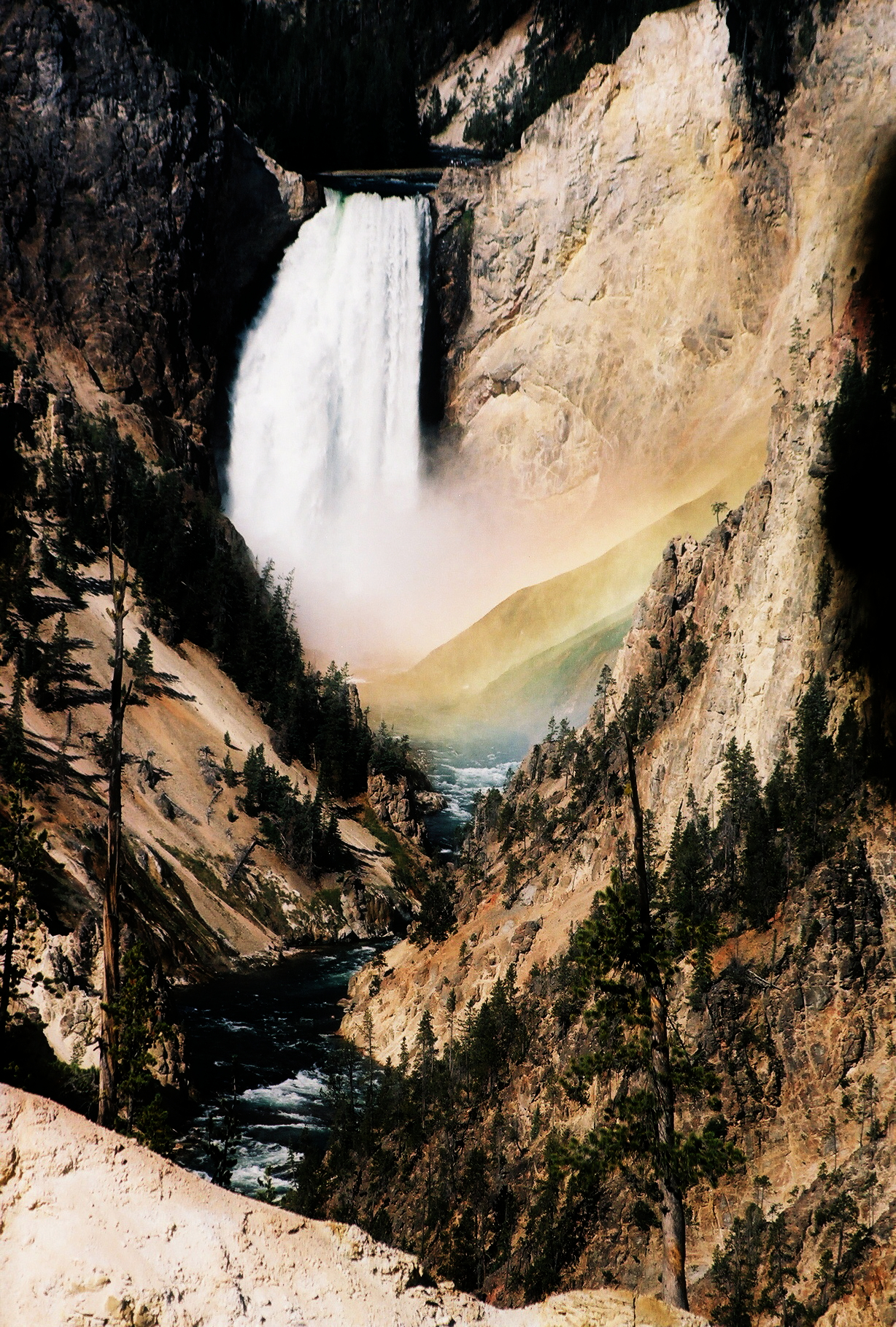
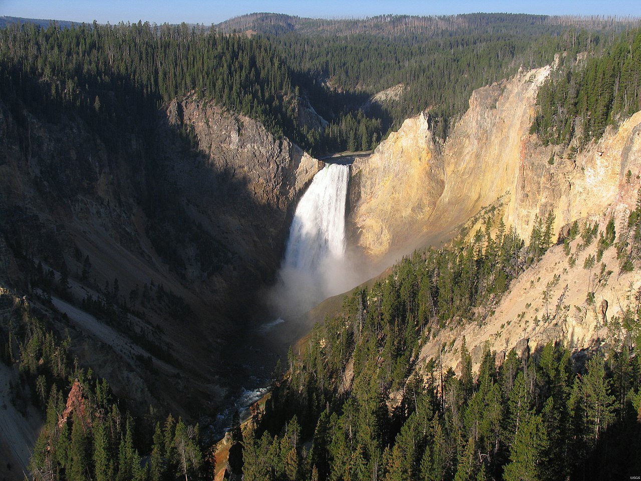
If you see one waterfall in Yellowstone, this is it. The Lower Falls of the Yellowstone River drops 308 feet — nearly twice the height of Niagara — over the lip of a 590,000-year-old rhyolite lava flow and into the Grand Canyon of the Yellowstone, a gorge carved up to 1,000 feet deep with walls stained yellow, ochre, and pink by hydrothermally altered rock. (The falls appears in our data under two slugs, Lower Yellowstone Falls and Lower Falls of the Yellowstone River; both refer to the same drop.) Flow swings dramatically with the season, from around 680 cubic feet per second in autumn to roughly 8,400 cubic feet per second at peak spring runoff, which is why it is the largest-volume waterfall in the Rocky Mountains and why late spring is when it thunders hardest.
There is no single 'the' viewpoint — the falls reward a tour of the canyon's two rims, and each overlook frames it differently. On the North Rim, the short, steep walk to the Brink of the Lower Falls (about 0.7 miles round trip on the NPS-signed trail, descending several hundred feet) puts you at the very edge where the river goes over; it is steep enough that the park rates it strenuous despite its length. Lookout Point and Red Rock Point give the classic side-on view down the canyon. On the South Rim, Artist Point — thought to have been named by park photographer F. J. Haynes as early as 1883 — delivers the postcard composition, with the falls framed by the canyon's colored walls, and it is reachable on a paved, nearly level path from the parking area.
The historic way to the base, Uncle Tom's Trail, descended several hundred steel steps bolted to the south canyon wall; it was named for 'Uncle Tom' Richardson, who in the late 1890s held an NPS permit to ferry tourists across the river and lead them to the foot of the falls. That trail has been closed since 2022, so plan around the rim overlooks rather than the descent. Best season for the canyon is late spring through early summer (May to June) for peak water, though the overlooks are spectacular all season; the South Rim Drive and several viewpoints typically stay accessible into fall.
Do not overlook the Upper Falls just upstream — a 109-foot drop where the river first breaks over harder rhyolite before reaching the bigger plunge. It has its own brink overlook and shares the same Canyon Village hub, making the two falls an easy pairing on a single stop. Canyon Village is the nearest services, with lodging, food, and the visitor center within a few minutes' drive of every overlook.
Roadside and short-walk falls: Tower, Gibbon, Lewis, and Wraith
Four of Yellowstone's most rewarding falls ask almost nothing of you, which makes them perfect for a driving loop or a day with mixed energy levels in the car. Tower Fall, near Tower Junction, plunges 132 feet over a cliff fringed with the eroded volcanic pinnacles — the 'towers' — that give it its name. An overlook beside the general store and picnic area frames it cleanly; the trail that once descended to the base has been closed for years due to erosion, so treat this as a roadside view. It runs reliably from late spring through fall (roughly May to October) and is rated easy because you barely leave the parking lot.
Gibbon Falls, between Madison Junction and Norris, is an 84-foot cascade where the Gibbon River slides down the edge of the Yellowstone Caldera rim — a rare spot where you can stand essentially on the caldera boundary. A short paved path with several railed vantage points runs along the pullout, making it one of the easiest stops in the park and a natural pause on the drive between the geyser basins and Norris. May through September is the prime window, when flow is healthy and the access road is open.
Lewis Falls, just south of Grant Village near the park's South Entrance, is a broad 30-foot block falls where the Lewis River spreads over volcanic rock close to the road. It is the kind of stop you can take in from a pullout or a few steps' walk, and it makes a good first or last waterfall depending on which direction you enter the park. Summer (June to September) is best, both for flow and because the South Entrance road is reliably open.
Wraith Falls, near Mammoth Hot Springs, is the one that asks for a little effort — an easy 0.8-mile round-trip walk across sagebrush meadow on Lupine Creek to a cascade that fans down a rock face. Sources put its height anywhere from about 79 feet to roughly 100 feet, a good reminder that smaller falls are inconsistently surveyed. It runs best in late spring to early summer; by late summer the creek thins and the cascade can look more like a wet slab than a waterfall. The flat, short trail makes it a popular family outing from the Mammoth area.
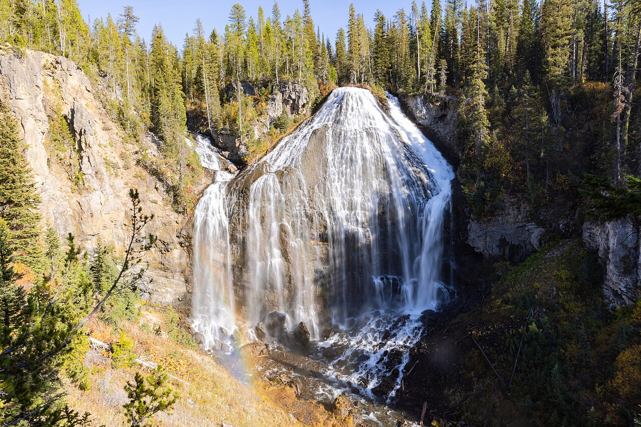
The geyser-basin falls: Fairy Falls and Mystic Falls
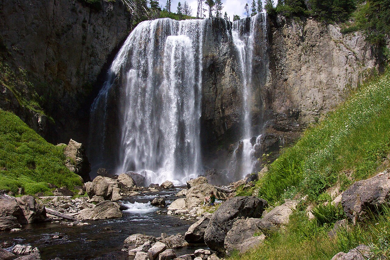
Two falls reward a moderate hike out of the Old Faithful and Lower Geyser Basin area and pair naturally with the park's thermal showpieces. Fairy Falls is a tall, slender 197-foot plunge — among the higher waterfalls in the park — that drops off the edge of the Madison Plateau into Fairy Creek. From the Fairy Falls trailhead off Fountain Flat Drive, it is roughly a 5-mile round trip on a gentle, nearly flat path through young lodgepole pine that regrew after the 1988 fires. The grade is easy enough that the hardest part is the distance, not the climb.
The reason most people pick this trail is that the same route passes the spur to the Grand Prismatic Spring Overlook, a viewing platform built by the park to give the famous aerial-style view of Yellowstone's largest hot spring. Adding the overlook spur lengthens the day only modestly, so you can stack the park's most photographed thermal feature and a 197-foot waterfall into one out-and-back. Summer to early fall is the working window; the falls hold water better than the snowmelt-dependent cascades but still ebb as the season dries out.
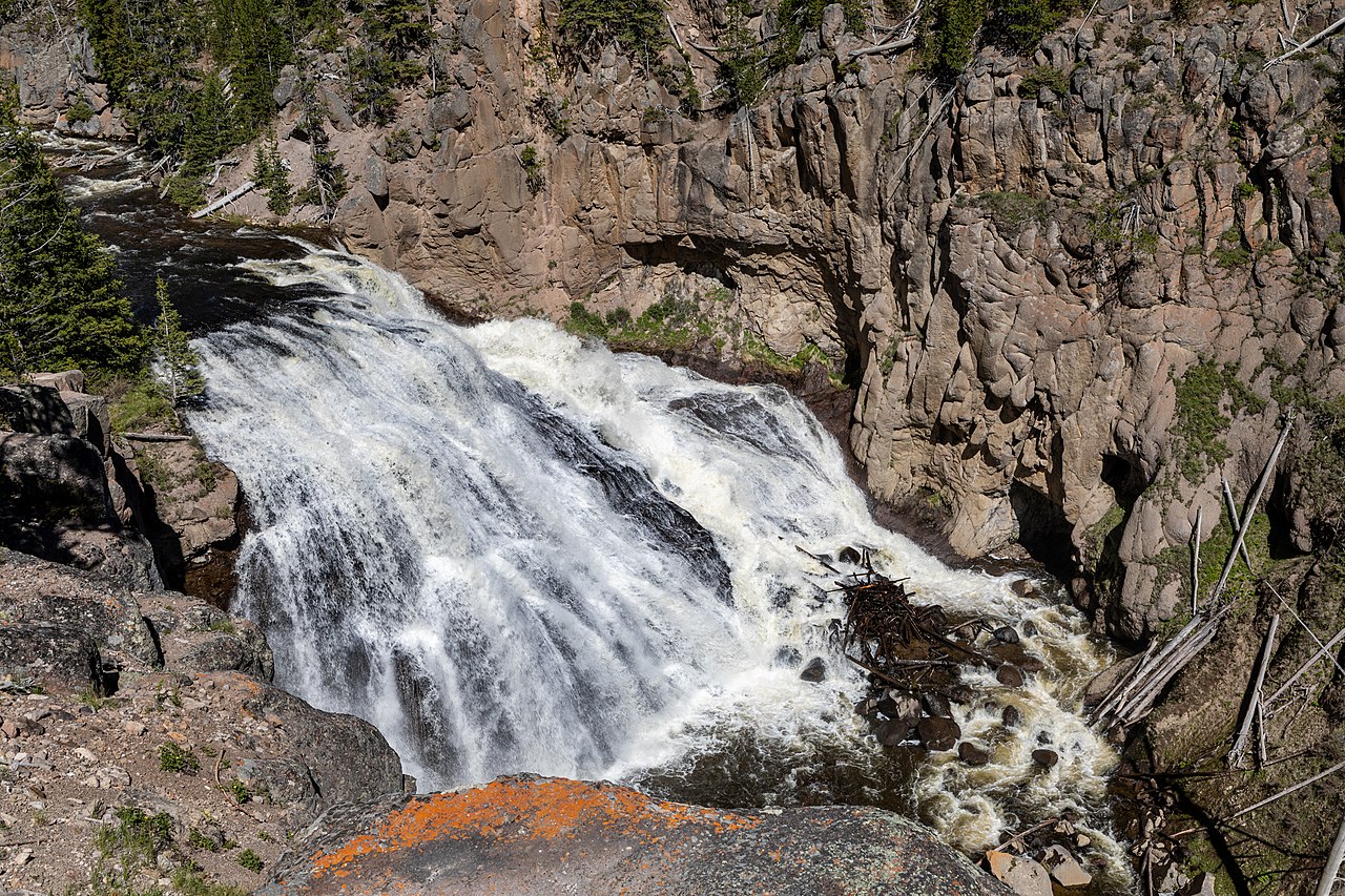
Mystic Falls is a 70-foot cascade where the Little Firehole River steps down a series of rock ledges at the edge of the Upper Geyser Basin. The NPS lists the basic out-and-back at about 2.4 miles round trip, with the option to climb roughly 500 feet of switchbacks to an overlook of the geyser basin and loop back for a longer day. It is a moderate hike — short, but with real elevation if you take the overlook loop.
Access here needs a caveat. The usual trailhead at Biscuit Basin has been closed indefinitely since the July 23, 2024 hydrothermal explosion at Black Diamond Pool, with further explosive activity in June 2026. As of recent reports the Mystic Falls trail can still be reached by parking at a turnout roughly a quarter mile south of the Biscuit Basin lot and picking up the trail from there — but this is exactly the kind of detail that changes, so confirm on the park's conditions page before counting on it. Best season is summer (June to September).
The backcountry giants: Union Falls and Dunanda Falls in the Bechler
The southwest corner of Yellowstone — the Bechler region, often called 'Cascade Corner' — holds the park's densest concentration of waterfalls and two of its most coveted backcountry destinations. These are not casual stops. They demand long days on foot, river fords, and in most cases an overnight, and the standard approach is from the Cave Falls or Bechler Ranger Station trailheads near Ashton, Idaho, on the park's remote western flank.
Union Falls is the showstopper: a 260-foot fan-type falls on Mountain Ash Creek, widely regarded as Yellowstone's second-tallest, where two streams converge and spread into a broad, sloping sheet of whitewater. The route runs roughly 15 to 16 miles round trip from the Cave Falls area, following the Bechler River Trail to the Mountain Ash Creek Trail and on past the Union Falls patrol cabin — and it includes a creek ford that can be dangerous at high water. It is a strenuous outing best done from mid-July through September, after the spring snowmelt drops and the fords become safe to cross.
Dunanda Falls is the other prize — a roughly 150-foot plunge where Boundary Creek drops off the Madison Plateau, reached via the Boundary Creek Trail from the Bechler Ranger Station. The full trip is on the order of 17 miles round trip and rates strenuous; sources put the one-way distance to the falls at around 8.4 miles with modest elevation change. A well-known bonus along this route is a set of natural hot-spring soaking pools near the base, fed where thermal water meets the creek, which is why the Boundary Creek corridor is a coveted multi-day destination. As with Union Falls, the season is mid-July to September, gated by snowmelt and ford safety.
Both hikes require a backcountry permit for overnight travel, and the Bechler's fords, mud, and mosquitoes early in the season are real considerations — this is the wettest, most water-logged corner of the park well into July. The payoff is solitude and scale you will not find at the roadside falls: full-day approaches, few people, and waterfalls that rival the canyon's headliners in height. Plan permits and crossings around the late-summer window, and treat any creek ford as the genuine hazard it is.