The Same Waterfall, Three Different Numbers
Pick almost any well-known waterfall and you'll find its height reported inconsistently. A state park brochure says one thing, a hiking blog says another, and the federal land manager lists a third figure. This isn't usually carelessness. A waterfall is a messy, three-dimensional thing — water spilling over an irregular cliff, breaking into chutes, pooling on ledges, and running on downhill long after the dramatic part is over. Turning that into a single number forces a series of judgment calls, and different people make them differently.
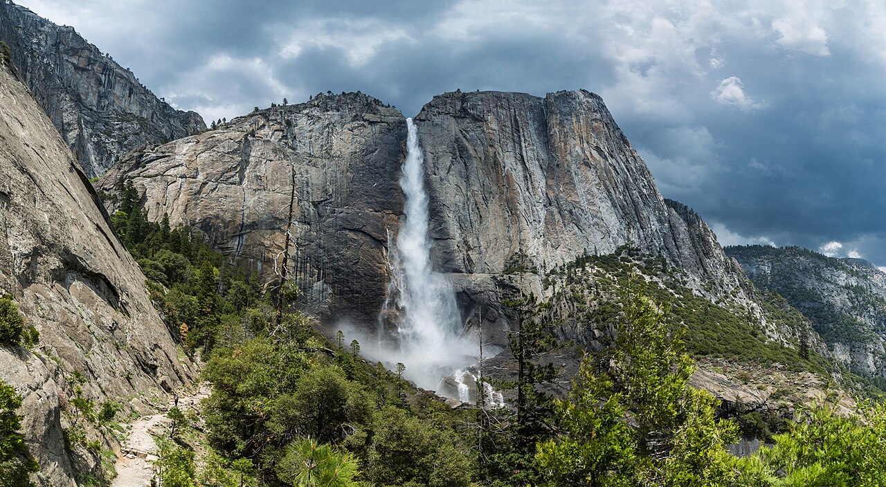
Take Yosemite Falls in Yosemite National Park, which the National Park Service lists at a total of 2,425 feet on Yosemite Creek. That figure is real and authoritative, but it is also a sum. Yosemite Falls is not one continuous sheet of water; it is three connected drops — an Upper Fall of roughly 1,430 feet, a middle section of cascades around 675 feet, and a Lower Fall of about 320 feet. The famous 2,425-foot number adds all three together. The single most dramatic leap, the Upper Fall, is a little over half that. Both numbers are correct; they answer different questions.
That gap between 'tallest single plunge' and 'total cumulative drop' is the single biggest reason reported heights disagree. Once you learn to ask which one a source is quoting, most of the confusion dissolves. A figure that sounds enormous for a given region is often a cumulative cascade total; a more modest number for the same feature is often the height of its largest individual drop.
The goal of this guide isn't to crown one 'true' height for every waterfall. It's to give you a mental checklist so that when you read a height figure, you know roughly what it represents, how much precision to trust, and whether two conflicting numbers are actually in conflict or just measuring different things.
Single Drop vs. Cumulative Cascade: The Big Divide
The most consequential decision a source makes is whether to report a waterfall as one drop or as the sum of many. A 'plunge' waterfall like Bridalveil Fall in Yosemite — listed at 620 feet on Bridalveil Creek — falls more or less as a single free-leaping column, so its height is relatively unambiguous: top of the drop to the base. A 'cascade' is the opposite. It tumbles down a long, stepped slope, and there's no obvious single drop to point to, so the conventional figure becomes the elevation lost from the top of the uppermost step to the bottom of the lowest one.
Crabtree Falls in Virginia's George Washington National Forest is the textbook example, and it shows how slippery the cumulative figure can be. It is often promoted as around 1,200 feet, but topographic maps put the total drop closer to 1,000 feet — which is the figure we list. Crabtree is a series of five major cascades plus several smaller ones; its single tallest drop is only about 400 feet, and the whole sequence is spread over roughly 2,500 feet of horizontal trail distance. So one waterfall legitimately carries a '1,000-foot' headline, a '400-foot' tallest-drop figure, and an inflated '1,200-foot' tourism number, all at once.
Amicalola Falls in Georgia's Amicalola Falls State Park makes the same point with cleaner data. Its widely cited 729 feet is explicitly a cumulative measurement — the total vertical loss as the creek tumbles down a series of rocky steps, not one single leap. Marketed as the tallest cascading waterfall east of the Mississippi, the '729 feet' is honest as long as you understand it's the height of a staircase, not a cliff. Comparing Amicalola's 729-foot cascade to Bridalveil's 620-foot plunge as if they were the same kind of measurement is an apples-to-staircases error.
This is why a smaller cascade can 'out-rank' a taller plunge in a list of regional giants. Cumulative cascade figures aggregate elevation that a free-fall plunge simply doesn't have available. Neither method is dishonest, but lists that mix the two without saying so are comparing things that aren't comparable.
Where You Start and Stop Measuring
Even for a tidy single drop, two careful people can disagree because the top and bottom of a waterfall are fuzzy. Where does the fall 'begin'? At the lip where the water first goes vertical, or higher up where the streambed steepens and the water starts to accelerate and break into whitewater? Where does it 'end'? At the plunge pool, or further down where the last froth of the splash zone finally calms? Move either boundary a few dozen feet and the published height moves with it.
Tiered waterfalls magnify this. Multnomah Falls in the Columbia River Gorge — listed at 620 feet on Multnomah Creek under the Columbia River Gorge National Scenic Area — is a good case because it was actually surveyed. The U.S. Geological Survey measured it in 1916 and arrived at a total of 620 feet, but that total breaks down into an upper fall of roughly 542 feet, a short connecting drop of about 9 feet over the rock between tiers, and a lower fall near 69 feet. A source that quotes only the upper fall would call Multnomah a 542-foot waterfall and not be wrong about that single tier — but it would be answering a narrower question than the headline 620-foot figure.
Tiered features like Yosemite Falls, Amicalola Falls, and Multnomah Falls therefore reward a specific habit: ask whether a number is the total across all tiers or the height of one named tier. The phrases to look for are 'total drop,' 'combined,' and 'including cascades' (cumulative) versus 'upper fall,' 'main drop,' or 'tallest tier' (single section). When a source doesn't say, the safest assumption is that a round, impressive number is the cumulative total.
Seasonal flow doesn't change the rock, but it changes what you see and where the visible water starts and stops, which is part of why field estimates drift. Multnomah flows year-round and is most powerful from late fall through spring (roughly November through May), while a snowmelt-driven fall like Bridalveil or Yosemite Falls peaks with the spring melt (about April through June) and can thin dramatically by late summer. The measured height is a property of the cliff; the impression of height is a property of the day you visit.
Survey Difficulty, Old Numbers, and Honest Uncertainty
Waterfalls are among the harder landforms to measure precisely. They sit on cliffs, in spray, often deep in gorges, with the top and bottom rarely visible from the same safe vantage point. Historically, heights were estimated from topographic maps by reading the contour lines between the lip and the base — a method that's solid for the overall figure but carries real error bars, because map contours come at fixed elevation intervals and the exact lip and base seldom land neatly on a contour line. That map-reading approach is exactly what nudged Crabtree Falls down from its promoted ~1,200 feet to a topographic ~1,000 feet.
Many circulating numbers also trace back to surveys done decades ago, like Multnomah's 1916 USGS measurement, and they've been copied from source to source ever since. That's not a flaw — a cliff doesn't grow — but it means a height you read in 2026 may rest on century-old fieldwork, and small transcription differences accumulate as the figure is republished. The U.S. Board on Geographic Names records a feature's official name and location in the USGS Geographic Names Information System (GNIS), but GNIS catalogs identity and position, not a certified height, so there often isn't one single federal 'height of record' to defer to.
Independent catalogs such as the World Waterfall Database exist partly to address this. They apply a consistent definition of what counts as the waterfall and re-derive heights from modern elevation data, which is why their figure for a given fall sometimes differs from a park brochure that's quoting a rounder, older, or more promotional number. When a careful catalog and an official land manager disagree by ten or twenty percent, that spread is usually telling you something real about measurement uncertainty — not that one of them is simply wrong.
The honest takeaway is that most waterfall heights are good estimates, not surveyed-to-the-foot certainties. A fall reported as '620 feet' is better read as 'about 600 feet,' and one at '729 feet' as 'roughly 700-plus feet of cumulative drop.' Treating the last digit as exact is the one mistake almost every casual source makes.
Marketing, Records, and the Inflation Pressure
There's a thumb on the scale, and it almost always pushes heights upward. 'Tallest waterfall in the state,' 'tallest east of the Mississippi,' and 'highest in North America' are powerful tourism phrases, and a slightly larger number protects or wins those titles. Crabtree Falls's persistent ~1,200-foot claim, against a topographic ~1,000 feet, is the clearest illustration: the bigger number makes a better superlative, so it survives in promotional material even after maps point lower.
Records also tempt sources to quietly switch measurement methods to whichever produces the most impressive result. If a single-plunge figure doesn't win a regional 'tallest' contest, a cumulative cascade total for the same feature might — so the cumulative number gets featured without the qualifier that it's cumulative. Amicalola's 729-foot cascade earns its 'tallest cascading waterfall east of the Mississippi' billing precisely because it's measured as a cumulative staircase; the phrase 'cascading' is doing real, honest work in that claim, and it matters when comparing against a free-falling plunge elsewhere.
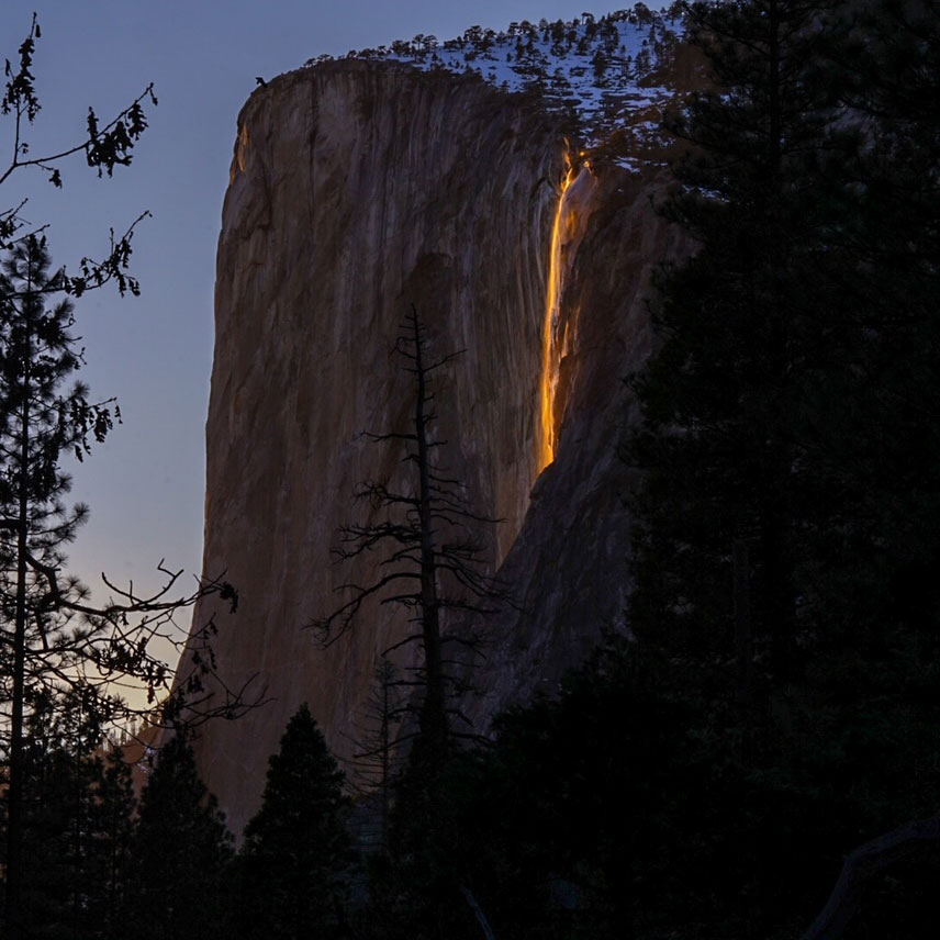
Seasonal marketing adds another layer that isn't about height at all. Horsetail Fall in Yosemite, on Horsetail Creek, is listed at 1,570 feet, but its fame has almost nothing to do with that figure. For roughly mid-to-late February, when there's enough snowmelt to feed it and the western sky stays clear at sunset, the falling water lights up orange and red — the 'firefall' effect — and that two-week window, not the height number, is what draws crowds. A waterfall's reputation and its measured size are two different stories, and visitors sometimes conflate them.
None of this means promotional numbers are lies. It means they're optimized — for superlatives, for round figures, for the most flattering measurement method. When you see an impressively large height attached to a 'tallest' claim, that's exactly the moment to ask whether it's a single drop or a cumulative cascade, and whether a topographic or database figure tells a more conservative story.
How to Read a Height Figure: A Practical Checklist
When you encounter a waterfall height, run it through a few quick questions before trusting it. First: single drop or cumulative? A free-leaping plunge like Bridalveil Fall (620 feet) reports cleanly as one number; a stepped cascade like Crabtree Falls or Amicalola Falls reports a sum, and the largest single drop within it is usually far smaller — Crabtree's tallest individual cascade is only about 400 feet of its ~1,000-foot total. If a tiered fall like Yosemite Falls or Multnomah Falls is involved, check whether the figure is the all-tiers total or one named tier.
Second: who is the source, and what is their incentive? A federal land manager (NPS for Yosemite Falls, Bridalveil, and Horsetail Fall; USFS for Multnomah Falls and Crabtree Falls) or a state-park authority (Georgia State Parks for Amicalola Falls) is generally more conservative than a tourism site chasing a superlative. An independent catalog like the World Waterfall Database is a useful tie-breaker because it applies one consistent definition across thousands of falls. When two reputable sources differ by ten or twenty percent, treat the range as the honest answer rather than insisting on a single digit.
Third: how precise is the claim pretending to be? Round numbers (620, 729, 1,000) are estimates; a figure quoted to the exact foot is usually still an estimate wearing a disguise. Mentally convert '620 feet' to 'about 600 feet' and you'll rarely be misled. And remember that height and experience diverge: Multnomah is most impressive in its high-water season (November through May), Yosemite Falls and Bridalveil peak with spring snowmelt (April through June), and Horsetail Fall's brief February firefall window has nothing to do with its 1,570-foot listing at all.
Put together, the rule of thumb is simple. The most trustworthy height is the one from a land manager or rigorous catalog that tells you its method — single drop or cumulative, all tiers or one. If a number won't tell you what it measured, treat it as a marketing figure: probably in the right neighborhood, probably rounded up, and not something to quote to the last foot.