How geographers actually classify waterfalls
There is no single official authority that decrees what a waterfall "is." Unlike river order or rock type, waterfall classification is a descriptive convention that grew out of field observation and was later codified by enthusiasts and references such as the World Waterfall Database and World of Waterfalls. What every system shares is a simple principle: you classify a waterfall by the geometry of its descent, not by its height, volume, or fame. The question is always the same. As the water leaves the lip, does it stay glued to the rock or break free of it? Does it stay a single thread or spread, split, or step?
From that one question you get the eight forms most guides recognize: plunge, horsetail, cascade, tiered, fan, block, punchbowl, and segmented. A plunge loses contact with the bedrock and falls through open air. A horsetail keeps at least partial contact the whole way down. A cascade tumbles over a staircase of rock. A tiered fall drops in distinct, separated steps. A fan widens as it descends while staying on the rock. A block pours as a wide sheet from a broad stream. A punchbowl shoots through a constriction and spreads into a pool. A segmented fall splits into two or more parallel ribbons.
These categories are not mutually exclusive, and most real waterfalls are honestly hybrids. The same drop can read as a plunge in flood and a horsetail in drought, because the volume of water determines whether it clears the rock. A tall fall is often several types stacked on top of each other. So treat the labels below as a vocabulary for describing what you see, not as boxes nature was obligated to fall into. The point of learning them is that they make you a sharper observer of the geology underneath every waterfall you visit.
Plunge and horsetail: does the water touch the rock?
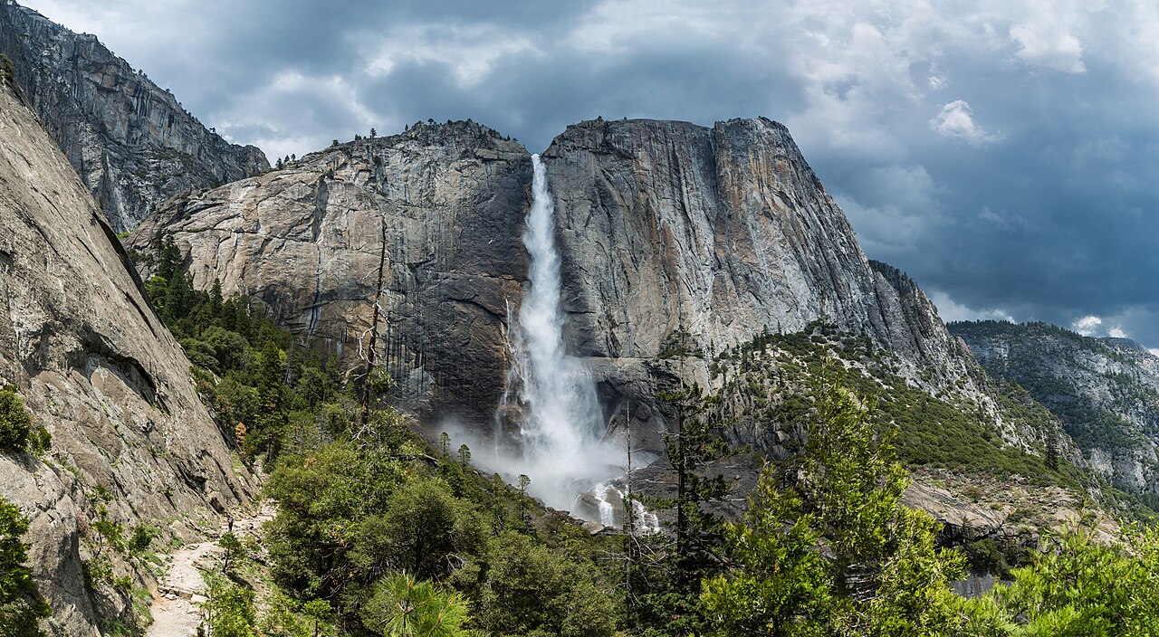
The cleanest distinction in the whole system is plunge versus horsetail, and it comes down to contact. A plunge waterfall leaves the cliff at the lip and free-falls through open air, losing contact with the underlying rock until it hits bottom. Bridalveil Fall in Yosemite National Park is the textbook case: water from Bridalveil Creek drops about 620 feet off a hanging valley and falls clear of the wall, which is why a stiff Yosemite Valley wind can blow the entire ribbon sideways and make it appear to billow like a veil. Known to the Southern Sierra Miwuk as Pohono, it is the first major fall most visitors see entering the valley, and the overlook sits just a half-mile walk from the parking area, under the care of the National Park Service.
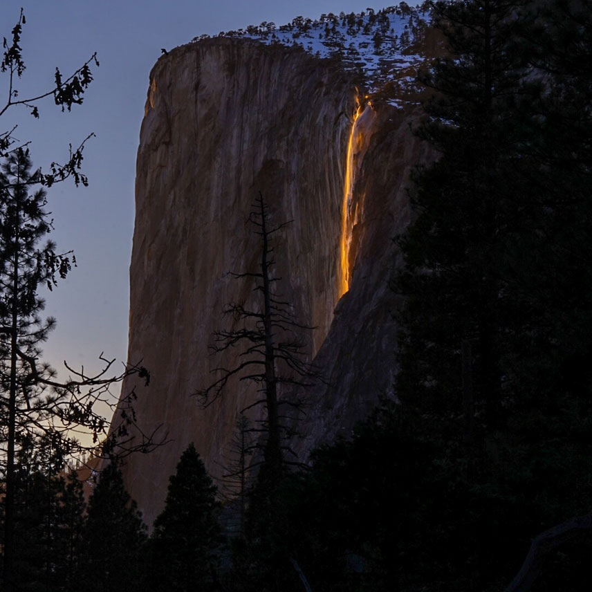
A horsetail waterfall is the near-opposite: the descending water maintains at least some contact with the bedrock the whole way down, so it traces and clings to the cliff face rather than arcing away from it. Horsetail Fall, also in Yosemite, is both the namesake of the type and one of the most dramatic examples in the country. It streams roughly 1,570 feet down the east face of El Capitan, hugging the granite, and is best known for the mid-to-late February "firefall," when a flowing fall, clear skies, and the low angle of the setting sun can briefly light the water orange and red. That spectacle is entirely dependent on the horsetail geometry: because the water stays on the rock, the sunset can illuminate it as a glowing line against the wall.
The contact rule also explains why plunge and horsetail can swap with the seasons. Horsetail Fall flows mainly in winter and early spring from snowmelt and rain; in a dry year it may not run at all. Many falls that plunge cleanly at peak flow degrade into rock-hugging horsetails as the water drops off later in summer. So when you read a height or a type in any database, remember it describes a typical condition, not an immutable fact, and that the same cliff can present two different faces in March and August.
Cascade, tiered, and block: stepping down the mountain
A cascade is water descending a series of rock steps, staying broadly in contact with the surface and tumbling rather than dropping. The cascade form is often what people picture as a "mountain stream waterfall," and its signature is length: cascades can run for a long horizontal distance down a slope. Crabtree Falls in Virginia's George Washington National Forest is a celebrated example, a chain of cascades on Crabtree Creek frequently cited as one of the tallest waterfalls east of the Mississippi. Note the careful wording in the sources: its commonly quoted figure of roughly 1,000 to 1,200 feet is a cumulative drop measured across five major cascades spread over a long distance, not a single sheer plunge. The tallest individual cascade in the sequence drops on the order of 400 feet. Reaching the upper viewpoints is a real outing, a moderate hike of about 3.4 miles round trip.
A tiered (or multi-step) waterfall drops in distinct, separated steps, where each tier is a recognizable fall in its own right, often divided by a pool or bench of rock. The distinction from a cascade is one of discreteness: a cascade blurs into a continuous tumble, while a tiered fall has clearly individual drops. Yosemite Falls is the classic tiered system and the tallest waterfall in North America at a combined 2,425 feet on Yosemite Creek. It comprises three named sections: the Upper Fall (about 1,430 feet), the middle cascades (about 675 feet), and the Lower Fall (about 320 feet). The full top-to-bottom hike is strenuous at roughly 7.2 miles, though the Lower Fall alone is reachable by a short, easy walk.
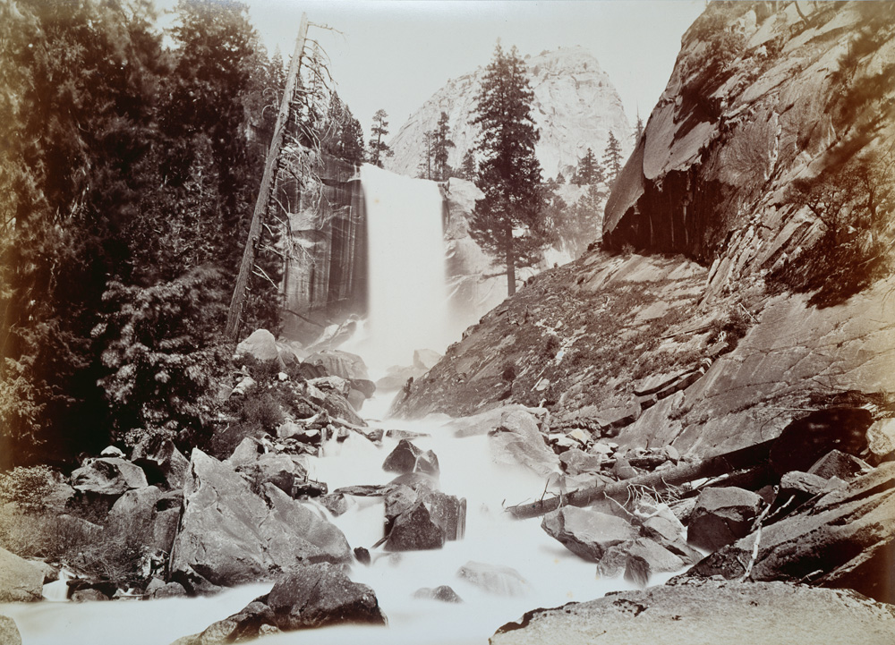
A block (or sheet) waterfall pours from a relatively wide stream or river, descending as a broad curtain rather than a narrow thread. Width and volume are the defining traits. Vernal Fall on the Merced River in Yosemite is a fitting block example: a 317-foot fall that carries the full force of the Merced and, in late spring, throws so much spray that the Mist Trail approach lives up to its name. The drenching is the whole point of a block fall, a wide, powerful river going over an edge all at once. The Vernal Fall footbridge and the steps above it sit about 2.6 miles round trip from Yosemite Valley, and the fall peaks with the May to June snowmelt.
Fan, punchbowl, and segmented: shaping the flow
The last three forms are about how the water is shaped by the rock at the moment of descent. A fan waterfall spreads out horizontally as it falls, growing wider toward the bottom while staying in contact with the bedrock, so it resembles an open hand or a Japanese fan. Arethusa Falls in New Hampshire's Crawford Notch State Park is a fine example, the headwaters of Bemis Brook sliding over a granite cliff and broadening as they go. It is often called the tallest single-drop fall in New Hampshire, with a height the Appalachian Mountain Club now estimates at about 140 feet. That number itself is a lesson in measurement uncertainty: earlier surveys put it at 176 feet and some lidar analyses suggest a figure closer to 155 feet. The falls sit at the end of a moderate hike of roughly 3 miles round trip from U.S. Route 302.
A punchbowl waterfall is constricted at the top, shooting through a narrow chute or slot, then spreading out into a wide pool at the base. The form is created by hard rock that pinches the stream before it opens into a basin. Zapata Falls in Colorado, on Bureau of Land Management land near Great Sand Dunes National Park, fits the type: the cold water of South Zapata Creek drops roughly 30 feet inside a narrow rock gorge, and reaching it requires fording the creek and scrambling into the slot. The setting makes Zapata distinctive: tucked inside a deep, shaded cleft in the Sangre de Cristo foothills, it freezes into a wall of ice in winter and stays cool even at high-desert summer temperatures. A short hike of about a mile gets you to the mouth of the gorge.
A segmented waterfall splits into two or more distinct parallel flows as it descends, separated by a rib of rock at the lip. Wailua Falls on the South Fork of the Wailua River on Kauai, Hawaii, is the postcard example, frequently appearing as a twin fall where the river divides into two ribbons before dropping into the plunge pool. Whether it runs as one curtain or two depends on the volume coming down off the mountains, another reminder that form follows flow. Wailua is also one of the dataset's starkest height-uncertainty cases: government maps list it around 80 feet, while hand measurements by guidebook authors put it closer to 173 feet. It is a roadside stop near Līhuʻe, viewable from an overlook with no hike required.
Why the labels blur, and the height numbers wobble
Once you have the eight forms in hand, the honest takeaway is that most real waterfalls refuse to sit in one box. Yosemite Falls is filed here as tiered, but its Upper Fall is a plunge, its middle section is a run of cascades, and the whole thing reads differently in May flood than in September trickle. Crabtree Falls is a cascade overall, yet individual steps within it plunge. Bridalveil plunges at high water and creeps toward a horsetail as flow drops. The classification you assign is really a description of the dominant character of the fall under typical conditions, which is exactly why two reputable sources can label the same waterfall differently and both be defensible.
Heights wobble for related reasons. A reported figure depends on what is being measured and how. Is it the single tallest free drop, or the cumulative descent across a long cascade? Crabtree's headline number is a sum across five cascades over a long horizontal run, not a sheer cliff, so comparing it to a single-plunge height is comparing two different quantities. Arethusa has been measured at 176, 140, and roughly 155 feet by different methods and decades. Wailua's 80-versus-173-foot gap comes down to old government map data against later hand measurement. None of these sources is lying; they are answering slightly different questions with slightly different tools.
The practical advice for any field guide reader is to treat a published height as a reasonable estimate with a margin, not a surveyed certainty, and to read the type as a starting point for what to look for rather than a guarantee of what you will see. The water level on the day you arrive, set by recent snowmelt and rain, may matter more than any label. That is also the most useful thing the classification system gives you: trained on these eight forms, you stop seeing "a waterfall" and start reading the rock, the constriction, the contact, and the flow that together produced the shape in front of you.