A waterfall is just two rocks wearing away at different speeds
Almost every waterfall on Earth comes down to a single idea: differential erosion. A river flows across rock of uneven hardness, and the softer rock wears away faster than the harder rock above or beside it. Over time the resistant rock is left standing as a lip or ledge while the weaker rock downstream is excavated into a plunge pool and a deeper channel. The river then has nowhere to go but over the edge. That step in the streambed is the waterfall, and the height of the step is a rough measure of how differently the two rocks have eroded.
The classic textbook version is a flat-lying hard layer sitting on top of a soft layer. Niagara Falls is the type example: the lip is held up by the Lockport Formation, a tough Silurian dolomite and limestone caprock, while the gentler shales beneath it erode out from underneath. Geologists literally call the resistant top layer the caprock because it caps the weaker rock below. Spray and turbulence eat into that soft underlayer, the unsupported caprock is left overhanging, and eventually slabs of it break off — which is the mechanism that keeps Niagara moving, a point we return to below.
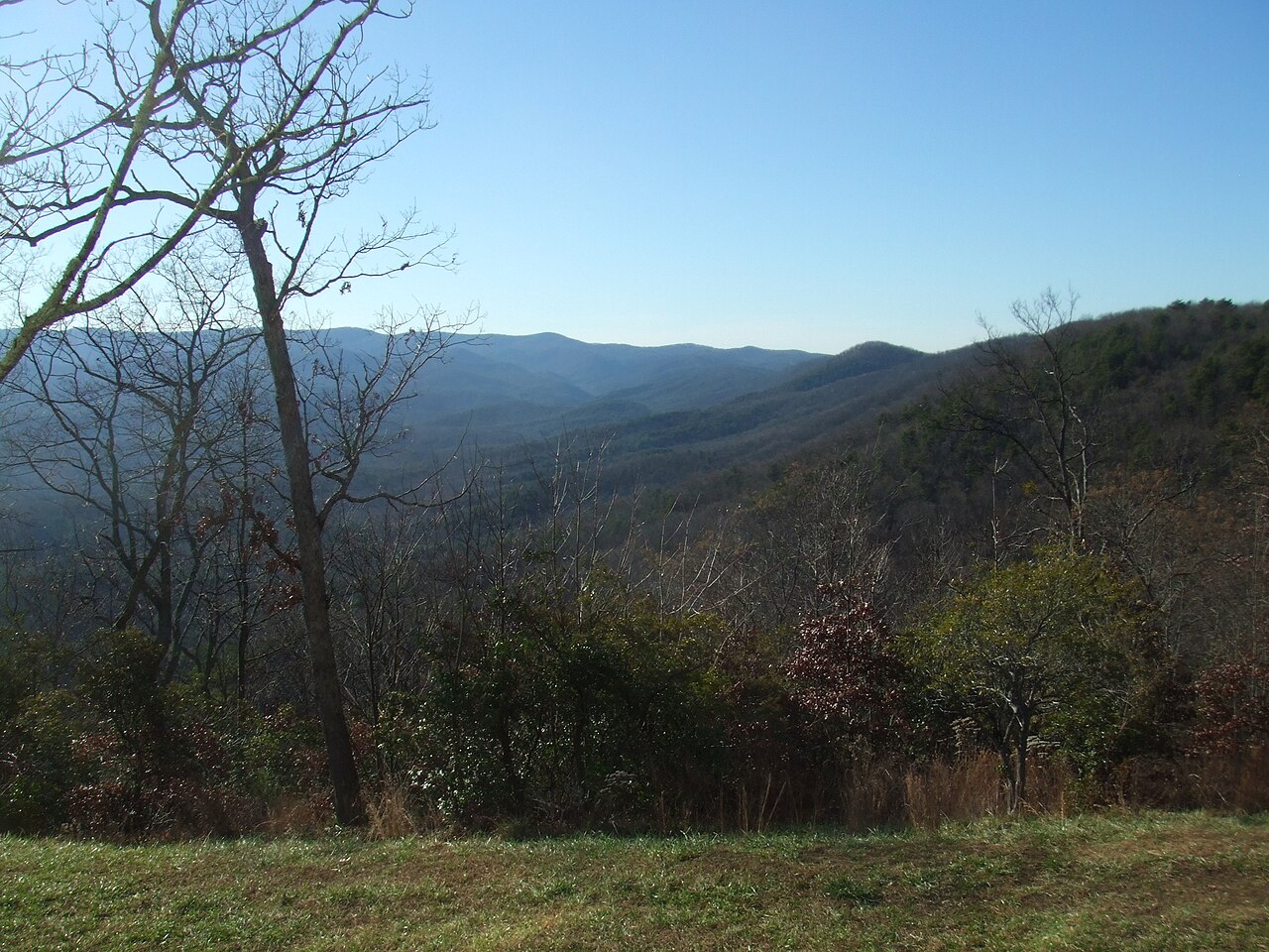
But hardness contrast does not have to come from neat horizontal layers. It can come from a fault or fracture zone where the rock has been shattered and is easier to erode, from a band of more resistant metamorphic rock crossing the stream, or from the boundary between an igneous intrusion and the softer country rock around it. What all waterfalls share is a place where the streambed's resistance changes abruptly. The Appalachian falls in this guide illustrate this well: Crabtree Falls in Virginia descends roughly 1,000 feet over Precambrian granitic gneiss and charnockite — metamorphic rock more than a billion years old — and Amicalola Falls in Georgia drops 729 feet where resistant quartzite and gneiss form the cliffs, with the creek's path steered by faults and fractures that exploit zones of weakness in the Blue Ridge.
It helps to be honest about the word 'height.' Reported waterfall heights vary a lot depending on what is being measured. The World Waterfall Database distinguishes overall height — the cumulative drop from the top of the uppermost cascade to the base, including interstitial stream sections — from single-drop height, the tallest uninterrupted free fall. A tiered waterfall like Multnomah Falls in Oregon (about 620 feet over two main steps) or Amicalola (a stepped cascade rather than a single plunge) will always read taller as a cumulative figure than as a single leap. When you see a number, it is worth asking which method produced it.
Why the tallest falls are usually glacial: hanging valleys
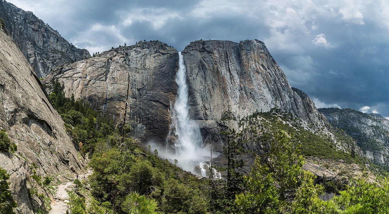
Differential erosion of hard and soft rock explains a step in a streambed. It does not, by itself, explain a 2,425-foot cliff. For that you usually need ice. The tallest waterfalls in the United States — including Yosemite Falls in California, North America's tallest at 2,425 feet in three sections — owe their height to glaciation and a feature called a hanging valley.
During the Pleistocene ice ages, large glaciers filled the main valleys. A thick trunk glacier in a major valley carries far more ice than a thin glacier in a small tributary valley, and more ice means more erosive power. The trunk glacier grinds its valley floor down deep and wide, carving the characteristic U-shaped cross-section, while the smaller tributary glacier cannot keep pace. When the ice finally melts, the tributary valley is left 'hanging' high on the wall of the deepened main valley. Any stream draining that tributary now reaches the edge and plunges — sometimes thousands of feet — to the trunk valley floor below.
Yosemite Valley is the showcase. The U.S. Geological Survey and the National Park Service describe a valley carved into Cretaceous granite and granodiorite, then deepened by glaciers into its sheer-walled form. Yosemite Creek's hanging valley stands well over 2,000 feet above the valley floor, which is why Yosemite Falls (best in the Apr–Jun snowmelt season, reached by a strenuous 7.2-mile trail to the top) is a near-vertical leap rather than a gentle cascade. The granite cooperated: pervasive vertical jointing let the ice pluck out nearly vertical walls, converting what might have been sloping cascades into clean plunges.
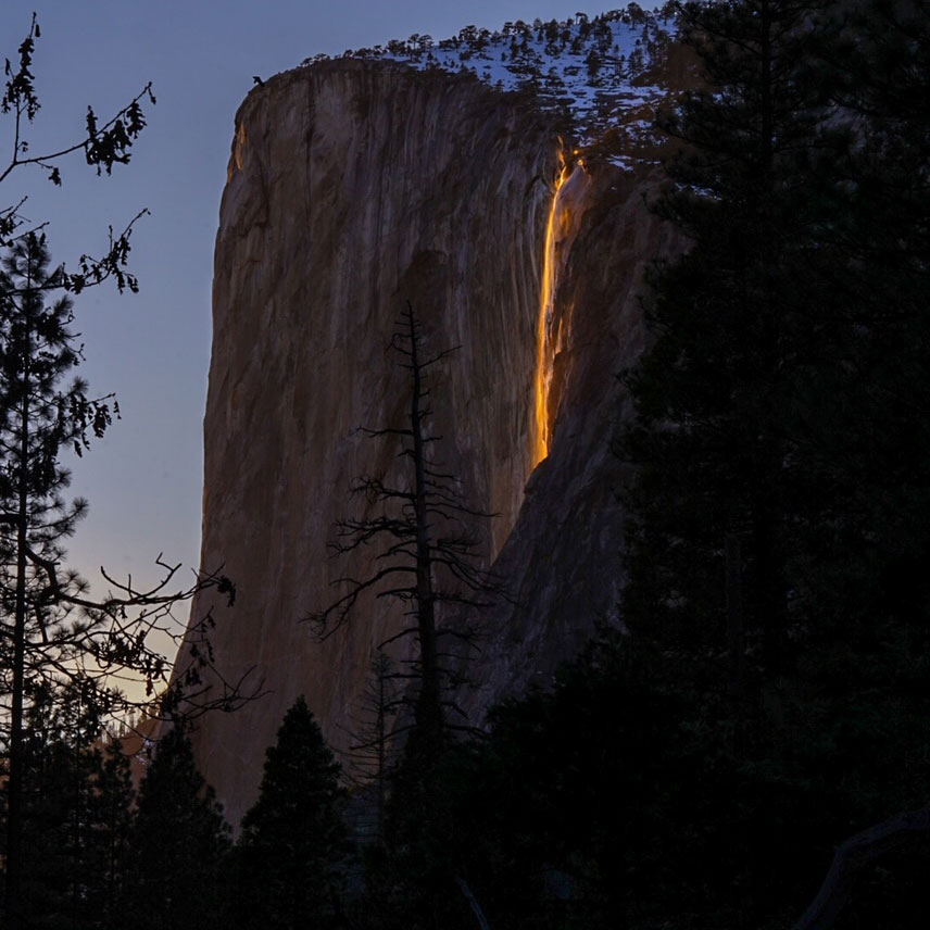
Glaciers also built the height behind Horsetail Fall, the ephemeral 'firefall' that streams about 1,570 feet down the east flank of El Capitan. Horsetail flows only in winter and early spring from snowmelt and rain, and dries up entirely in summer — a reminder that the cliff is the permanent geological feature and the water is just a seasonal visitor to it. For roughly two weeks in mid-to-late February, if the fall is flowing and the western sky is clear, the setting sun backlights the water and it glows molten orange. The fiery color is pure optics and timing; the wall it falls down is glacial geology.
Knickpoints: the moving step in the river's profile
To understand why waterfalls move, it helps to picture a river not as a line but as a profile — a curve of elevation from headwaters to mouth. Left undisturbed for long enough, rivers tend toward a smooth, concave 'graded' profile, steep near the source and gentle near the sea. A waterfall is a sharp break in that curve: an abrupt steepening where the river drops far more quickly than the reaches above and below it. Geologists call such a break a knickpoint.
Knickpoints form whenever something disturbs the river's equilibrium. A band of resistant rock creates one. So does a hanging valley left by glaciers, or a fault that suddenly raises the land downstream, or a drop in base level — for example, when sea level falls or a main valley is cut deeper and a tributary is left perched, exactly the situation at a hanging valley. In every case the river now has excess energy concentrated at one point, and flowing water spends that energy doing what it does best: eroding.
Crucially, a knickpoint is not anchored to a fixed spot on the ground. It is anchored to a condition — the hardness contrast or the elevation mismatch that created it. As long as that condition can be eroded, the step itself migrates. The energy is focused right at the lip and the plunge pool, so that is where erosion is fastest, and the whole feature tends to work its way backward, against the current, up the valley. A waterfall, in other words, is best understood not as a place but as a process that happens to be passing through a particular place right now.
Headward erosion: why falls retreat upstream over time
The upstream migration of a knickpoint is called headward erosion, and it is the single most important reason waterfalls are temporary features. The mechanism at a caprock waterfall is the one Niagara makes famous. Water plunging over the hard lip pounds and swirls at the base, and that turbulence, along with freeze-thaw and the simple force of falling water, scours out the softer rock beneath the caprock. The hard layer is gradually left with nothing under it — an overhang. Sooner or later the overhanging slab cracks along its joints and collapses into the plunge pool. When it does, the lip of the falls has just jumped a few feet upstream. Repeat that for thousands of years and the waterfall walks up the river, leaving a steep-walled gorge behind it to mark where it has been.
Niagara puts numbers on it. Before the mid-20th-century diversion of much of its flow for hydropower, the falls retreated on the order of about 3 feet per year, and over the roughly 12,000 years since the last ice retreated it has carved a gorge several miles long. With far less water now going over the brink, modern erosion has slowed to roughly a foot per year — a useful illustration that the rate of headward erosion scales with how much water, and therefore how much energy, is available to do the cutting. More discharge, more undercutting, faster retreat.
Not every fall retreats by collapsing caprock slabs. On the hard crystalline rock of the Appalachians, retreat is slower and grindier — abrasion by sediment, prying along fractures and foliation, and freeze-thaw widening joints. Amicalola Creek, for instance, is incising along fault and fracture zones that gave it a head start, slowly sawing the knickpoint back into Amicalola Mountain. The style of retreat differs with the rock, but the direction is the same in essentially every case: upstream. Waterfalls migrate toward their own headwaters, consuming the very step that defines them.
Taken to its conclusion, headward erosion is self-erasing. As a knickpoint retreats it also tends to lower and soften — the plunge pool fills, the gorge lengthens, the drop becomes a rapid, the rapid becomes a riffle. Given enough time and no fresh disturbance, the river smooths its profile back toward grade and the waterfall ceases to exist. The reason the planet still has waterfalls is that geology keeps making new knickpoints: ice ages carve new hanging valleys, faults offset the land, and resistant rock keeps being exposed faster than rivers can erase the steps.
Reading these forces in the falls themselves
Once you know what to look for, a waterfall's shape tells you how it formed. A tall, clean vertical plunge from a side valley high on a sheer wall — Yosemite Falls, Horsetail Fall — is the signature of a glacial hanging valley: a tributary stream left stranded above a glacially overdeepened trunk valley. A neat horizontal lip with an undercut, overhanging brow and a gorge trailing downstream points to a flat-lying caprock and active headward retreat, the Niagara pattern. A stepped, segmented cascade like Amicalola Falls or Multnomah Falls reflects a stack of layers or fracture sets of differing hardness, each resistant band making its own little step.
The rock type behind the falls is the other half of the story. Multnomah Falls pours over the Columbia River Basalt Group — specifically the Grande Ronde Basalt — where the cliff exposes a stack of individual Miocene lava flows; the falls themselves were sharpened during the catastrophic Missoula Floods around 15,000 years ago, when glacial-outburst megafloods scoured the Columbia River Gorge and left tributary streams hanging above the deepened main channel. That basalt is durable, which is one reason Multnomah flows year-round and is so easy to reach (the lower viewpoint is barely 0.2 miles from the lodge). The Appalachian examples sit on ancient metamorphic rock instead — the billion-year-old gneiss and charnockite of Crabtree Falls, the quartzite and gneiss of Amicalola — hard crystalline rock that yields slowly and tends to produce long, stepped cascades rather than single great leaps.
Timing is geology too, on a human scale. The reason so many of these falls peak in spring — Crabtree Falls and Yosemite Falls both run hardest in the Apr–Jun snowmelt, Amicalola after heavy spring rain — is that the cliff is permanent but the water is seasonal. The same snowmelt and storm runoff that make a fall roar in spring are also, in that same moment, the energy doing the long, slow work of cutting the knickpoint backward. Every spectacular high-water spring is a small installment in a multi-thousand-year process of the waterfall erasing and relocating itself. What you are watching is not a fixed monument but a moving front in a river's unfinished negotiation with its own bedrock.