What GNIS Actually Is
GNIS stands for the Geographic Names Information System, the official federal repository of names for natural and cultural features in the United States and its territories. It is operated by the U.S. Geological Survey (USGS) on behalf of the U.S. Board on Geographic Names (BGN), a body created by Congress in 1890 and re-established in its present form by Public Law in 1947. The Board's job is narrow but consequential: to make sure that when any part of the federal government refers to a place, it uses one standardized name. GNIS is where that standardized name is recorded and published.
The practical upshot is that there is exactly one federally recognized name for each feature. Multnomah Falls in Oregon is 'Multnomah Falls' in GNIS, not 'Multnomah Cascade' or 'Larch Mountain Falls,' even if older maps or local usage said otherwise. Those alternative spellings and historical names are not discarded; GNIS stores them as 'variant names' attached to the same record. The official name is the one the National Park Service, the Forest Service, and the maps in this guide are all supposed to agree on, which is precisely why a reference like ChasingFalls anchors its entries to the GNIS name first and treats everything else as an alias.
GNIS is also deliberately limited in scope. It is a names database, not a hydrology or recreation database. It will tell you that a feature called Yosemite Falls exists, that it is in California, in Mariposa County, and where it sits in latitude and longitude. It will not tell you the falls is 2,425 feet tall, that it runs hardest during spring snowmelt from April to June, or that reaching the top is a strenuous 7.2-mile round trip. Those facts come from other sources, which is the central reason a field guide cannot simply reprint GNIS and call it done.
How a Feature Becomes a 'Falls' in the System
GNIS sorts every record into one of roughly 43 broad feature classes, categories defined purely to help people retrieve features of a similar kind. Waterfalls live in the class named 'Falls,' which the system defines as a perpendicular or very steep descent of water over a section of a stream. That single class covers an enormous range of real-world features: the 620-foot, two-tier plunge of Multnomah Falls, the 729-foot stepped descent of Amicalola Falls in Georgia, and the seasonal, gossamer Horsetail Fall on the granite of El Capitan in Yosemite all carry the same feature-class label. The class tells you what kind of thing a record describes; it makes no judgment about height, beauty, or fame.
A name reaches GNIS one of two ways. The overwhelming majority of records are names already in long-established public use that were compiled into the system from official maps, charts, and other authoritative sources when the database was built. New or contested names, by contrast, go through a formal proposal process. Anyone can petition the U.S. Board on Geographic Names to name an unnamed feature or to change an existing name, and the Board's Domestic Names Committee evaluates the proposal, gathers input from state geographic names authorities and local governments, and votes. The committee includes representatives from the Departments of the Interior, Commerce, Agriculture, Defense, and Homeland Security, among others. When the Board approves a name, that decision date is recorded in the GNIS entry, which is why some records carry a BGN decision date and many older ones do not.
The Board also enforces naming conventions that shape what you see. It has long resisted commemorating living people and has worked to retire derogatory names, which is how some long-standing labels on the landscape have changed in recent years. For a waterfall this mostly means the name itself is stable and vetted, even when nothing else about the feature is officially measured. The system is rigorous about the word on the map and intentionally agnostic about the water behind it.
What a GNIS Record Tells You (and What It Doesn't)
Open a GNIS record for a waterfall and you get a compact, reliable set of fields: the official name, the feature class ('Falls'), the state and county, latitude and longitude coordinates, the name of the USGS topographic map the feature appears on, any variant names, and, where applicable, the BGN decision date. For Crabtree Falls, that record places the feature in Nelson County, Virginia; for Amicalola Falls, in Dawson County, Georgia. These are the fields that are authoritative and stable, and they are exactly the fields you want to trust when you are confirming that two different sources are talking about the same cascade rather than a similarly named one a county away.
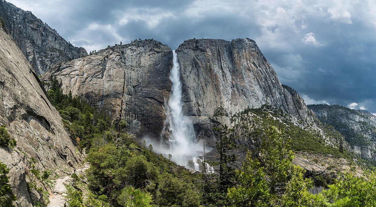
GNIS does carry an elevation figure, but it is important to understand what that number is not. The elevation in a GNIS record is explicitly non-official. It is an ancillary value interpolated from terrain elevations in the USGS 3D Elevation Program (3DEP), sampled at the location of the feature's coordinate point. That is the ground elevation at a single point near the feature, not a measured height of the waterfall's drop. A GNIS elevation for Yosemite Falls reflects the terrain at its plotted point, not the 2,425 feet of vertical the water travels from lip to base. Anyone who reads a waterfall's height off the GNIS elevation field has misread the database.
There is one more wrinkle worth knowing. In 2021 the system removed an entire group of so-called administrative or man-made feature classes, including airport, bridge, building, dam, park, school, and trail. Natural features like waterfalls, streams, and summits were unaffected and remain fully in GNIS, but this is why you can no longer look up the trailhead parking lot or the state park boundary in the same database that holds the falls. The names of the parks and forests that manage these waterfalls now live in other federal datasets, not in GNIS.
Why Height Is the Hardest Number to Pin Down
Because GNIS does not publish an official waterfall height, every height you read in a field guide comes from somewhere else, and those sources do not always agree. The reason is methodological. A waterfall's 'height' can mean the single tallest unbroken drop, or it can mean the cumulative descent across every tier and cascade between the top and the bottom. Those two numbers can differ by hundreds of feet for the same feature, and a citation that does not say which one it is using invites confusion.
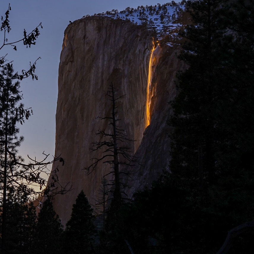
Multnomah Falls is the clean teaching example. Its widely cited 620-foot height is a cumulative figure: roughly 542 feet for the upper falls, a short 9-foot step in the middle, and 69 feet for the lower falls. None of those individual drops is 620 feet; the headline number is the sum. The same logic applies to the tiered and cascading falls throughout this guide. Amicalola Falls at 729 feet and Crabtree Falls at roughly 1,000 feet are stepped, multi-pitch descents, and Yosemite Falls at 2,425 feet is a famous three-section feature (upper fall, middle cascades, lower fall) whose total dwarfs any single one of its parts. Horsetail Fall's frequently cited 1,570-foot figure likewise describes a long horsetail-form descent down the face of El Capitan, not one sheer plunge.
ChasingFalls reports these heights because they are the standard published figures hikers will encounter on agency signage and reference databases, but it treats them as approximate and source-dependent rather than surveyed truths. Where a number reflects a cumulative cascade rather than a single drop, that distinction matters more than another digit of false precision. The honest position is that GNIS fixes the name and the location with confidence, and the height is a separate, softer measurement borrowed from the World Waterfall Database, the managing agency, and topographic interpretation.
How ChasingFalls Builds on the GNIS Foundation
GNIS is the spine of this guide and the first thing each waterfall entry is anchored to. The official name and the coordinates resolve the identity question that bedevils waterfall references: there are dozens of 'Crabtree Falls' and 'Bridal Veil Falls' across the country, and only the GNIS record plus its state and county can tell you which one you mean. Starting from GNIS guarantees that when this guide says Crabtree Falls in Nelson County, Virginia, it is naming a specific federally recognized feature and not blending it with a different Crabtree Falls elsewhere.
From that foundation, the guide layers on the operational facts GNIS deliberately omits, each from the agency that actually manages the land. The land manager field tells you whose rules apply and whose website to check for closures: Yosemite Falls and Horsetail Fall sit inside Yosemite National Park under the National Park Service; Crabtree Falls is in the George Washington National Forest and Multnomah Falls in the Columbia River Gorge National Scenic Area, both U.S. Forest Service; and Amicalola Falls is run by Georgia State Parks. The watercourse, drainage, and seasonal timing come from hydrologic and agency sources, which is how the guide can tell you that Horsetail Fall on Horsetail Creek only glows for a couple of weeks in mid-to-late February when late-day sun, sufficient snowmelt, and clear skies coincide, while Multnomah Falls on Multnomah Creek runs every month of the year.
The access details follow the same discipline. The 0.2-mile paved path to the Multnomah Falls viewing bridge, the 1-mile climb at Amicalola, the 3.4-mile round trip at Crabtree, and the strenuous 7.2-mile out-and-back to the top of Yosemite Falls are trail facts drawn from the managing agencies, not from GNIS, which dropped trails from its scope entirely in 2021. The result is a single entry where the name and location are federally standardized and traceable, and every other claim is sourced to the body that measured or manages it. That separation, official identity from everything else, is the whole point of leaning on GNIS rather than pretending it does more than it does.