Why Portland Is a Waterfall Hub
Few American cities are as well positioned for waterfall chasing as Portland. The Columbia River Gorge — a deep, glacier- and flood-carved canyon that forms the border between Oregon and Washington — runs east from the metro area, and its south wall is laced with creeks that drop hundreds of feet off basalt cliffs to reach the river. The Historic Columbia River Highway, completed in the 1910s, was deliberately routed past these falls, which is why so many of them sit within a few steps of pavement. South and east of the city, the slopes of Mount Hood add a second cluster of falls fed by snowmelt and cold mountain creeks.
The practical upshot is that you can build a waterfall day-trip around almost any energy level. Several of the best-known falls are roadside or a few hundred yards from a trailhead, while others reward a half-day hike into wilderness. Most of the Gorge falls share a single corridor along Interstate 84 and the old highway, so it is genuinely possible to see four or five distinct waterfalls in one outing without driving more than a handful of miles between them.
This guide leans on public records — USGS place-name data, U.S. Forest Service and Oregon State Parks land-management information, and crowd-sourced trail mileage — rather than personal anecdote. Reported heights for waterfalls vary widely by source and method: some figures describe a single clean drop, others sum a whole staircase of cascades, and surveyors rarely agree to the foot. Treat the heights below as well-documented approximations, not precise measurements.
Roadside and Short-Walk Falls (Under a Mile)
If you have limited time or are traveling with people who do not want to hike, start with the cluster of falls that require almost no walking. Wahkeena Falls, near Corbett, is essentially roadside: a horsetail-type cascade reported at around 242 feet on Wahkeena Creek, with a paved viewpoint and a short 0.4-mile trail segment if you want to climb a little higher. It runs best in spring and after heavy rain (roughly April through June), when snowmelt and storms swell the creek.
A short distance east, Horsetail Falls drops about 176 feet right beside the Historic Columbia River Highway. You can photograph it from the parking area without walking at all, though a connecting trail (about 2.5 miles if you continue up the loop) lets you tie it into nearby falls. Ponytail Falls — also called Upper Horsetail Falls — sits on the same Horsetail Creek a short 0.8-mile climb above it; at roughly 88 feet, its signature feature is the trail that passes behind the curtain of water through an undercut alcove. Both are managed within the Columbia River Gorge National Scenic Area by the U.S. Forest Service and flow best in spring.
Multnomah Falls is the centerpiece of this stretch and the most-visited natural attraction in Oregon. Plunging in two tiers off Multnomah Creek, it is commonly cited at around 620 feet of combined drop, making it one of the tallest waterfalls in the United States by that cumulative measure. The lower viewing area and the Benson Footbridge are a very short walk from the lot; reaching the very top is a steeper paved climb of roughly 2.4 miles round trip rated moderate. Multnomah flows year-round but is at its most dramatic in winter and spring (November through May). Be aware that during peak season the falls often require a timed-entry permit — check current Forest Service rules before you go.
Easy Gorge Hikes (1 to 3 Miles)
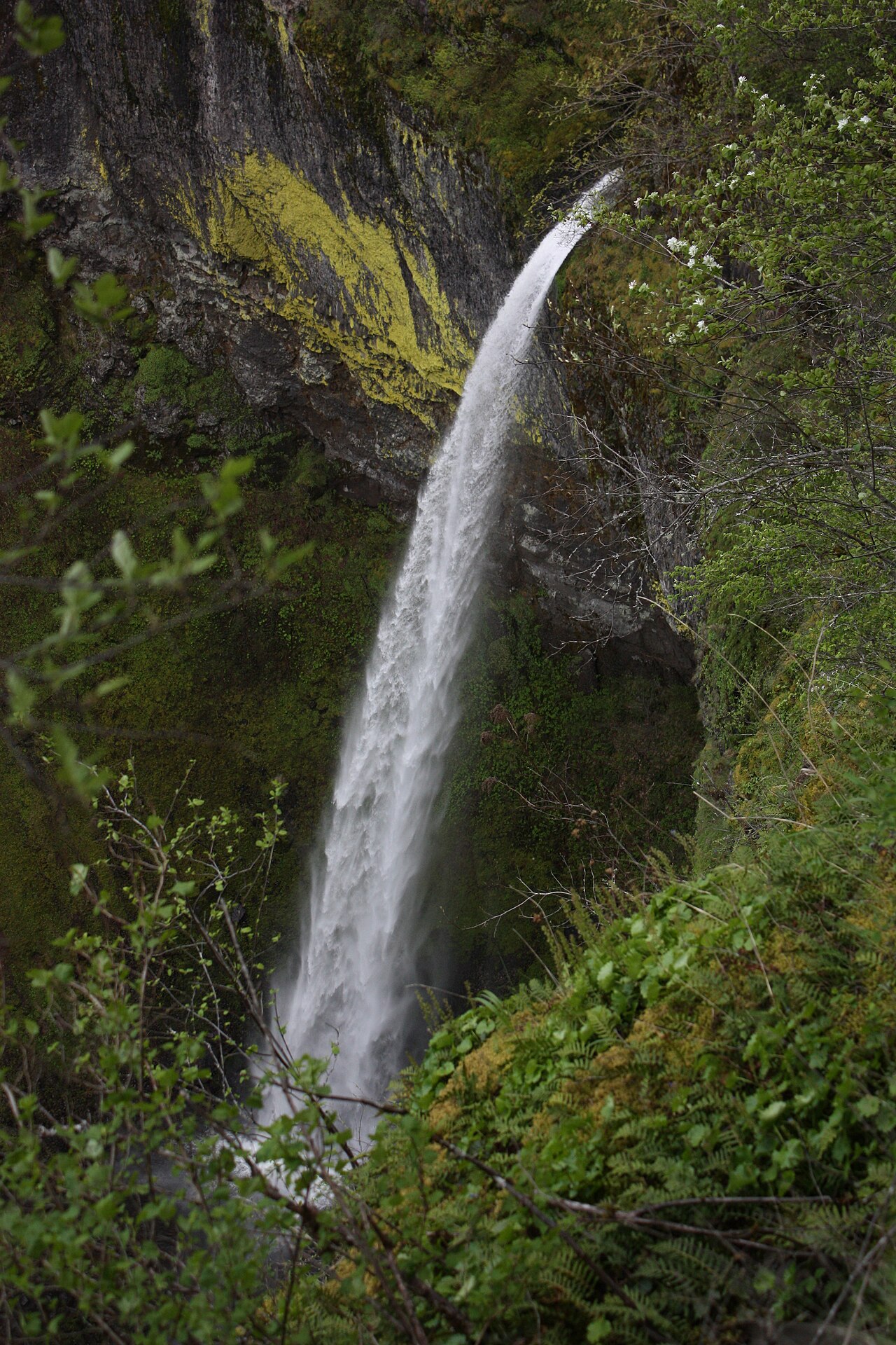
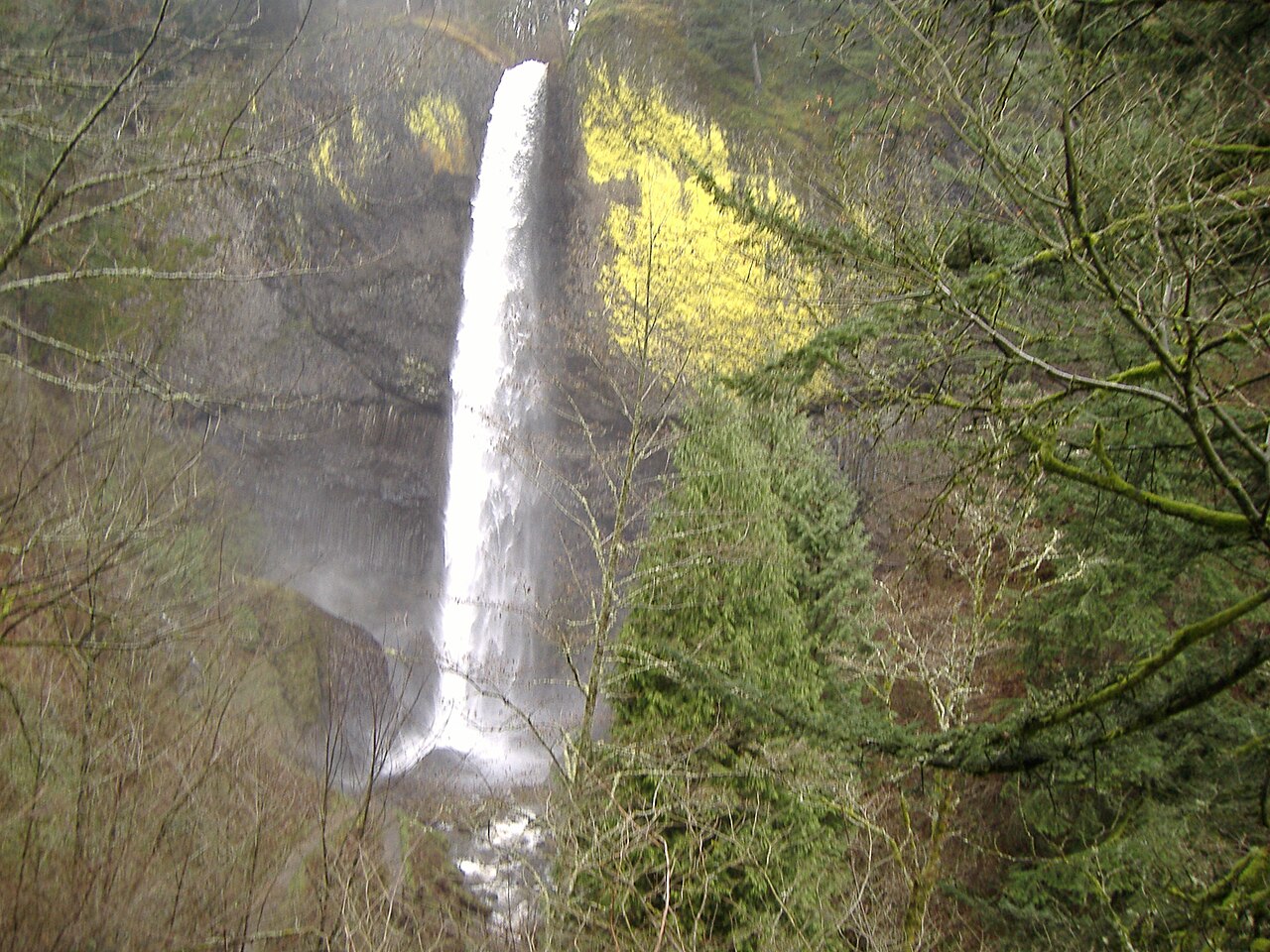
When you are ready to trade pavement for a real trail, the Gorge offers several easy-to-moderate hikes that pay off quickly. Latourell Falls, inside Guy W. Talbot State Park near the community of Latourell, is a striking 224-foot plunge that pours straight off a columnar-basalt wall streaked with bright yellow lichen. A lower viewpoint sits close to the parking area, and a roughly 2.3-mile loop (rated easy) climbs to an upper falls and back. As a state park managed by Oregon State Parks, it has no Forest Service pass requirement, and it runs hardest during winter and spring high flow.
Wahclella Falls, near Cascade Locks, is one of the most rewarding short hikes in the Gorge. The trail follows Tanner Creek about 2.4 miles round trip — easy walking — into a narrow box canyon where the tiered, roughly 127-foot falls crashes into a pool. Because Tanner Creek drains a large basin, Wahclella holds good flow year-round, with the heaviest volume from late winter through spring. Elowah Falls, on McCord Creek near Warrendale, is another easy payoff: a single graceful plunge of about 213 feet reached by a 1.5-mile trail, at its best in spring.
These falls share the Gorge's basalt geology, which is why so many of them are tall, vertical plunges rather than gentle cascades — the Columbia River Basalt Group laid down hard, cliff-forming layers that creeks tumble off cleanly. Parking can fill early on weekends at every trailhead in this corridor, and some require a Northwest Forest Pass or day-use fee, so arrive early and carry the appropriate pass.
Bigger Gorge Hikes (3 to 5 Miles)
For hikers wanting a longer outing, the Oneonta and Eagle Creek drainages deliver. Triple Falls, on Oneonta Creek near Corbett, is a segmented waterfall of about 135 feet where the creek splits into three parallel channels before dropping — an unusual and photogenic form. The hike runs roughly 3.6 miles round trip at a moderate grade and is at its best in spring. Along the way, the Wahkeena–Multnomah trail network connects several of the falls above, so strong hikers sometimes string them together into a single loop.
Fairy Falls, a delicate fan-shaped cascade of about 20 feet on Wahkeena Creek, is modest in height but a pleasant target on a moderate 3.1-mile round-trip hike that climbs above Wahkeena Falls. It rewards the climb with a wide, lacy spread of water over mossy rock, and like its neighbors it peaks in spring.
Punch Bowl Falls, on Eagle Creek near Cascade Locks, is one of the Gorge's iconic images: a short 33-foot drop that funnels through a narrow chute into a wide, round, deep green pool — the "punch bowl" that gives it its name. The classic view is from a gravel bar reached by a moderate hike of roughly 4.2 miles round trip. The Eagle Creek Trail is famous and beautiful but includes exposed cliff-edge sections with cable handholds, so it is not ideal for small children or anyone uneasy with heights. A Northwest Forest Pass is required, and the trail is best from spring through fall. Note that the 2017 Eagle Creek Fire burned much of this area; check current Forest Service conditions, as trail status can change.
Mount Hood Falls Worth the Drive
When the Gorge is crowded — or when its falls drop in flow during late summer — the Mount Hood corridor offers a quieter alternative on a slightly longer drive from Portland. The trade-off is seasonality: many Hood-area trails depend on snowmelt and stay snow-covered or washed out well into the season, so timing matters more here than in the Gorge.
Tamanawas Falls, on Cold Spring Creek near Parkdale, is a broad block-type waterfall of about 110 feet that spreads across a dark wall of volcanic rock. The hike runs roughly 4 miles round trip at a moderate grade through forest and along the creek. Because it sits on the east side of the mountain, it is generally best from late spring through fall once snow clears, and the trail has historically been subject to washout and closure — confirm it is open before driving out.
Ramona Falls, near Zigzag, is the marquee Mount Hood hike on this list. Fed by Ramona Creek inside the Mount Hood Wilderness, it is a wide fan of water — about 120 feet — that cascades down a fractured basalt face in a fine, lacy sheet, one of the most distinctive falls in the region. It demands commitment: roughly 7.1 miles round trip at a moderate grade, and the loop normally requires fording or crossing the Sandy River, where a seasonal footbridge may or may not be in place. The realistic window is mid-July through early October, after high water recedes. A wilderness-area self-issue permit and a trailhead pass are typically required, so check Mount Hood National Forest rules before setting out.
Planning Your Waterfall Day-Trip
The single biggest variable in Gorge and Hood waterfall chasing is water volume, and it is strongly seasonal. The classic falls peak from late fall through spring, when rain and snowmelt are at their highest — most of the Gorge falls list winter or spring (roughly November through May) as prime. By late summer, smaller creeks like the ones feeding Fairy Falls slow to a trickle, while big-basin falls such as Multnomah and Wahclella keep flowing year-round. Mount Hood falls run on the opposite schedule, becoming reliably accessible only after the snow melts in summer.
Logistically, plan around crowds and permits. Multnomah Falls frequently requires a timed-entry permit in peak season, and many trailheads require a Northwest Forest Pass or charge a day-use fee; the Oregon State Parks falls like Latourell do not. Parking is the real bottleneck — popular lots fill by mid-morning on summer and holiday weekends, so an early start does more for your day than anything else. Carry the right pass, check current trail status (wildfire, washout, and bridge closures all recur in this region), and have a backup falls in mind.
A reasonable beginner itinerary strings together the western Gorge roadside and short-walk falls: Latourell, Wahkeena, Horsetail and Ponytail, and Multnomah all sit within a short drive of one another along the Historic Columbia River Highway, letting you see several distinct waterfalls in a half-day with minimal hiking. Save Wahclella, Triple Falls, and Punch Bowl for a day when you want more trail time, and reserve Ramona and Tamanawas for summer trips out toward Mount Hood. Always confirm heights, distances, and access details against current official sources before you rely on them — figures cited here are drawn from documented records but can change.