Why Asheville Is the Waterfall Capital of the East
The mountains around Asheville sit on top of the Blue Ridge Escarpment, a steep geological wall where the high plateau of the southern Appalachians drops abruptly toward the Piedmont. Rivers that wander gently across the highlands suddenly have hundreds of feet of elevation to give up in a short distance, and the result is one of the densest concentrations of waterfalls in the eastern United States. Transylvania County, just southwest of Asheville and centered on the town of Brevard, even brands itself the "Land of Waterfalls." Within roughly an hour or two of downtown Asheville you can reach a 411-foot plunge, a movie-famous three-tiered cascade, gorges you can drive straight through, and a falls you can walk behind.
What makes the region unusual is not just the number of falls but how many are genuinely easy to reach. Several of the best are roadside or a short, mostly flat walk from a parking area, while others reward a moderate hike of a couple of miles. That range means a single trip can mix drive-up overlooks with real trail miles, and you can tailor a day to children, casual visitors, or serious hikers. The land is almost entirely public, managed by the U.S. Forest Service in the Pisgah and Nantahala National Forests, by North Carolina State Parks at Gorges State Park, and by DuPont State Recreational Forest.
Two practical caveats shape every plan here. First, reported heights vary widely depending on whether a source measures a single plunge, a full multi-drop run, or includes upstream cascades, so the numbers below should be read as good approximations rather than surveyed precision. Second, Hurricane Helene caused serious damage across Western North Carolina in late 2024, and some trails, roads, and access points have been closed, rerouted, or rebuilt. Always check the managing agency's current conditions page before you drive out, because a falls that was open last season may be on a temporary closure.
DuPont State Forest: The Hunger Games Waterfalls
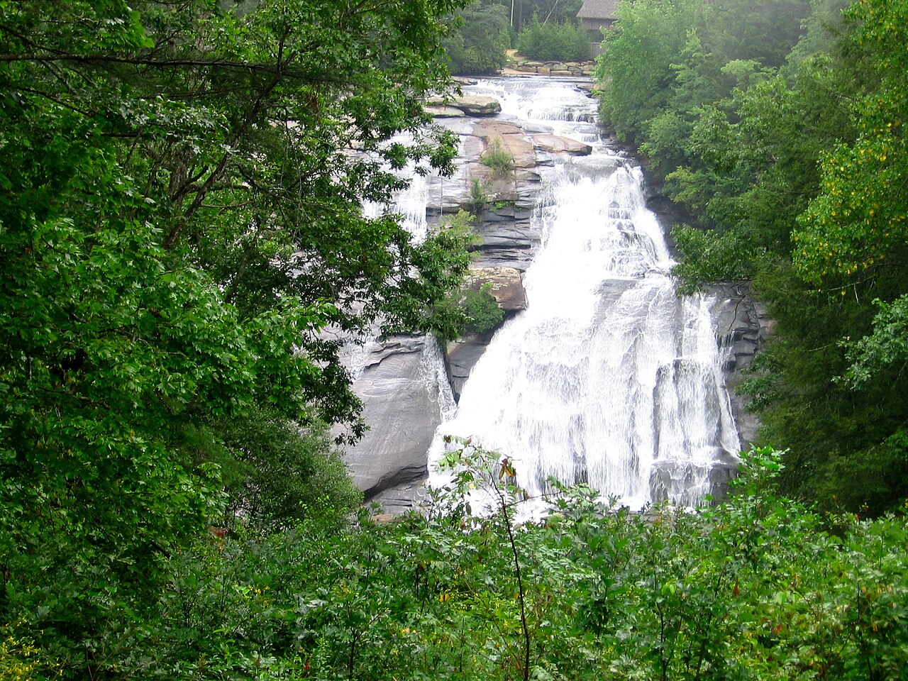
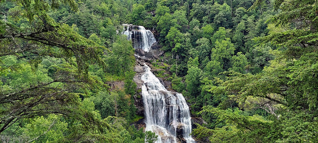
If you have time for only one waterfall outing near Asheville, DuPont State Recreational Forest near Brevard is the classic choice. The roughly 10,000-acre forest sits about an hour southwest of downtown Asheville, and a single corridor of the Little River strings together several big falls in quick succession. The headline attraction is Triple Falls, a tiered drop of about 125 feet whose three stacked sections appeared in The Hunger Games and The Last of the Mohicans. The walk in from the popular High Falls or Hooker Falls access areas is short, on the order of just over a mile each way, with a moderate rating thanks to some grade and stairs down to the viewing area.
Continue up the same river and you reach High Falls, the tallest waterfall in DuPont at about 150 feet. It is a broad, sliding cascade rather than a sheer plunge, and a covered overlook gives you the postcard view; figure roughly a two-mile round trip on a moderate trail to take it in. Many visitors combine Triple Falls, High Falls, and the lower, family-friendly Hooker Falls into one loop of several miles, which is the most efficient way to see the heart of the forest in a single morning.
For a longer day, push on to Bridal Veil Falls, a wide 120-foot cascade reached by a longer round trip of roughly 4.4 miles on moderate terrain. This is the Bridal Veil that featured in the final scene of The Last of the Mohicans, and the lower slab is gentle enough that on safe-flow days people sometimes sit at its base. DuPont's falls run year-round but look most dramatic in late winter and spring when snowmelt and rain swell the Little River; summer brings thinner flow but warmer, greener forest, and autumn frames the water in color. Note that DuPont was among the areas affected by storm damage, so confirm trail status before visiting.
Pisgah National Forest and the Brevard Gorges
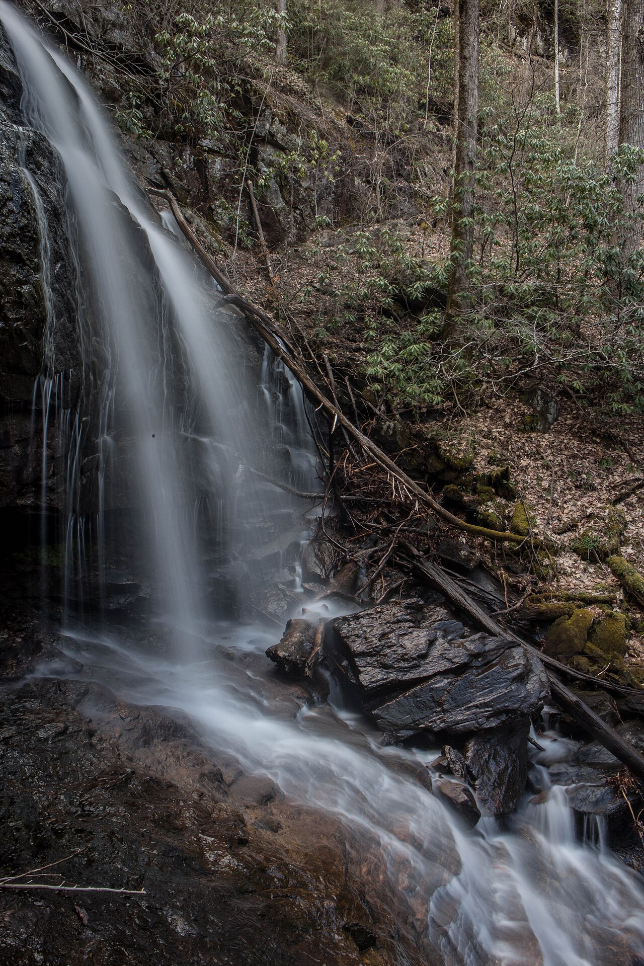
The Pisgah National Forest surrounds Brevard on three sides and holds dozens of falls along the Davidson River and its tributaries. A good moderate-effort target is Daniel Ridge Falls, a roughly 150-foot cascade that sheets down a broad rock face. The loop to reach it runs about a mile from the trailhead off Forest Service roads in the Davidson River area and is rated easy, making it a strong choice when you want a real trail without a hard climb. Spring is the best season, when meltwater spreads the curtain of water across the full width of the rock.
East of Asheville, near the town of Old Fort, Catawba Falls reopened on May 31, 2024 after a two-year, multi-million-dollar rebuild by the Forest Service. The lower falls is a long, mossy cascade that most sources put around 100 feet (some measure the full lower run at closer to 200 feet), reached by a moderate hike of about 2.2 miles round trip along the Catawba River. The project added retaining walls, boardwalks, 580 stairs, three overlooks, and a 60-foot observation tower so hikers can safely continue to the upper falls, a stretch rated intermediate because of the steps and elevation. Spring flow is strongest; check conditions, as this corridor also saw Helene-related impacts.
Closer to the Blue Ridge Parkway near the community of Busick, Roaring Fork Falls is an under-the-radar gem: a tumbling cascade of about 100 feet reached by an easy walk of roughly 1.3 miles on an old roadbed, gentle enough for families. North of there, off US-19 between Maggie Valley and Cherokee, Soco Falls is a striking double waterfall of about 120 feet on the edge of lands of the Eastern Band of Cherokee Indians. A short but locally steep path of around half a mile leads to viewing decks; the site reopened in July 2025 with a new accessible parking area and upper viewing platform, and the second, smaller falls is easiest to see in winter when the leaves are down.
The Cullasaja Gorge and the Highlands Road
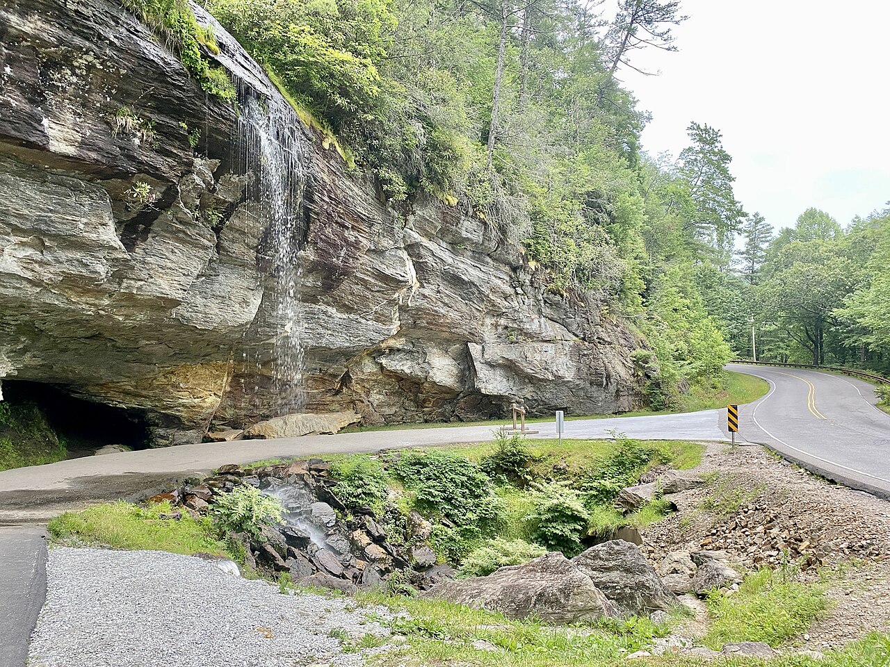
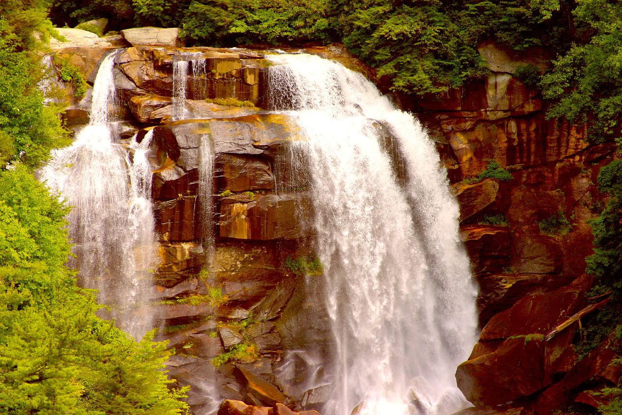
Southwest of Asheville, US-64 between Highlands and Franklin threads the Cullasaja River Gorge, a 7.5-mile stretch of the Mountain Waters Scenic Byway where waterfalls appear one after another from the car. This is the area's best drive-up waterfall corridor, almost entirely within the Nantahala National Forest. The headliner is Cullasaja Falls, a powerful cascade in the gorge that this guide lists at about 200 feet, though some sources report it closer to 250 feet; it is roadside, with limited pull-off parking and fast traffic, so caution is essential when you stop to look.
A few miles upstream toward Highlands, Dry Falls is the gorge's signature experience. The falls drops about 75 feet, and a short, paved trail of only about 0.2 miles leads you onto a walkway that passes behind the curtain of water, which is how it earned its name: under the overhang you stay relatively dry while the river roars past in front of you. It is one of the most accessible big falls in the state and a reliable crowd-pleaser, strongest after spring rains and snowmelt from roughly March through June.
The gorge's other landmark is Bridal Veil Falls near Highlands (distinct from the DuPont falls of the same name), a 120-foot ribbon you can once drive or walk beneath, though the road behind it has been restricted to foot traffic because of rockfall and winter ice. For a short hike rather than a roadside stop, Glen Falls south of Highlands is a tiered series of drops totaling around 70 feet on the East Fork of Overflow Creek; a moderate trail of about 2 miles descends past several viewpoints, best in spring when flow is high. Because the descent is steep, save energy for the climb back out.

Gorges State Park, Whitewater Falls, and the Tallest of Them All
On the southern edge of the region, where North Carolina meets South Carolina, two state-line gorges hold the area's most dramatic drops. Gorges State Park near Sapphire protects the lower Horsepasture River, and its standout is Rainbow Falls, a thundering cascade of about 150 feet that throws spray and, on sunny days, the rainbows it is named for. The hike from the park's main access area runs about 3.1 miles round trip and is rated moderate, following the river through rugged terrain; the trailhead was relocated into the park in 2009, so older directions pointing to NC 281 are out of date. Spring is the prime season for full flow.
A short drive away, Whitewater Falls is the giant of the region. The Forest Service describes the upper falls on the Whitewater River, in the Nantahala National Forest near Sapphire and Cashiers, as the highest waterfall east of the Rockies, with a commonly cited height of 411 feet. That figure measures the full tiered run of the river as it drops down the escarpment rather than a single sheer plunge, and the "highest in the East" claim is debated against contenders like Crabtree Falls in Virginia and others, so treat the superlative as a marketing-grade boast rather than a settled fact. Either way, the falls is enormous and easy to reach: a paved path of roughly half a mile leads to an upper overlook, with a stairway descending toward closer river-level views.
Whitewater Falls appears in this region's records under more than one name and listing, reflecting how sources split the upper and lower drops and how the river crosses into South Carolina downstream. Whatever the bookkeeping, plan it as one of the easiest big-payoff stops in the mountains: short walk, huge falls, and a high overlook that takes in the whole gorge. As with everything here, the water is loudest in spring and after heavy rain, and you should check Forest Service and State Park conditions before you go, since post-Helene closures and seasonal road work can affect access.