How We Ranked Them (and Why the Numbers Wobble)
Ranking waterfalls by height sounds like a tidy exercise — pull the published figure for each, sort the column, done. In practice, the single most important fact about any waterfall ranking is that the headline number is rarely a clean measurement. The figure you see on a trail sign, in a guidebook, or in a federal database can describe one of several very different things: the height of a single uninterrupted plunge, the combined drop of a multi-tier waterfall, or the full length of a long, sliding cascade that loses elevation over hundreds of feet of bedrock without ever leaving the rock.
We built this list around documented heights from public records — the U.S. Geological Survey's Geographic Names Information System (GNIS), the National Park Service, the U.S. Forest Service, state park agencies, and the volunteer-compiled World Waterfall Database, which standardizes measurement methods across thousands of falls. Where those sources disagree, and they often do, we used the most widely cited figure and flagged the waterfall's form (plunge, tiered, horsetail, cascade) so you can judge what the number actually represents. Heights are reported in feet, rounded the way the source rounds them.
The honest caveat: a 1,000-foot cascade and a 1,000-foot plunge are not the same spectacle, and they are not measured the same way. A plunge like Bridalveil Fall in Yosemite drops 620 feet through open air in one continuous fall. A cascade like Crabtree Falls in Virginia is credited with roughly 1,000 feet of total descent, but that figure is the cumulative drop across a long series of steps and slides down the mountainside — no single sheet of water falls 1,000 feet. Both are legitimately listed at their numbers; they simply answer different questions. Throughout this guide we note which kind of height each entry represents so the ranking stays meaningful rather than misleading.
One more rule shaped the list: we stuck to waterfalls with a real, documented public presence — a named watercourse, a managing agency, and a location you can actually find. That keeps the ranking grounded in verifiable records rather than the inflated or disputed figures that circulate for remote, hard-to-survey drops.
The Giants: Over 1,000 Feet
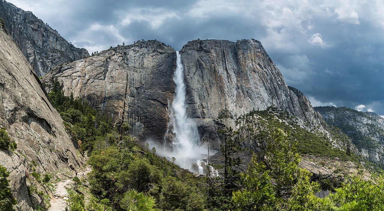
At the top of any honest American height list sits Yosemite Falls in California, credited at 2,425 feet. It is the tallest waterfall in the United States by the most commonly cited measurement and one of the tallest in the world — but that 2,425 figure is a tiered total, not a single plunge. The waterfall is really three connected drops: the 1,430-foot Upper Yosemite Fall, a churning middle cascade of roughly 675 feet, and the 320-foot Lower Yosemite Fall. Fed by Yosemite Creek, it surges with spring snowmelt from April through June and can dwindle to a trickle by late summer. You can see the lower fall from a flat, paved path, but the full Yosemite Falls Trail to the top is a strenuous 7.2-mile round trip managed by Yosemite National Park.
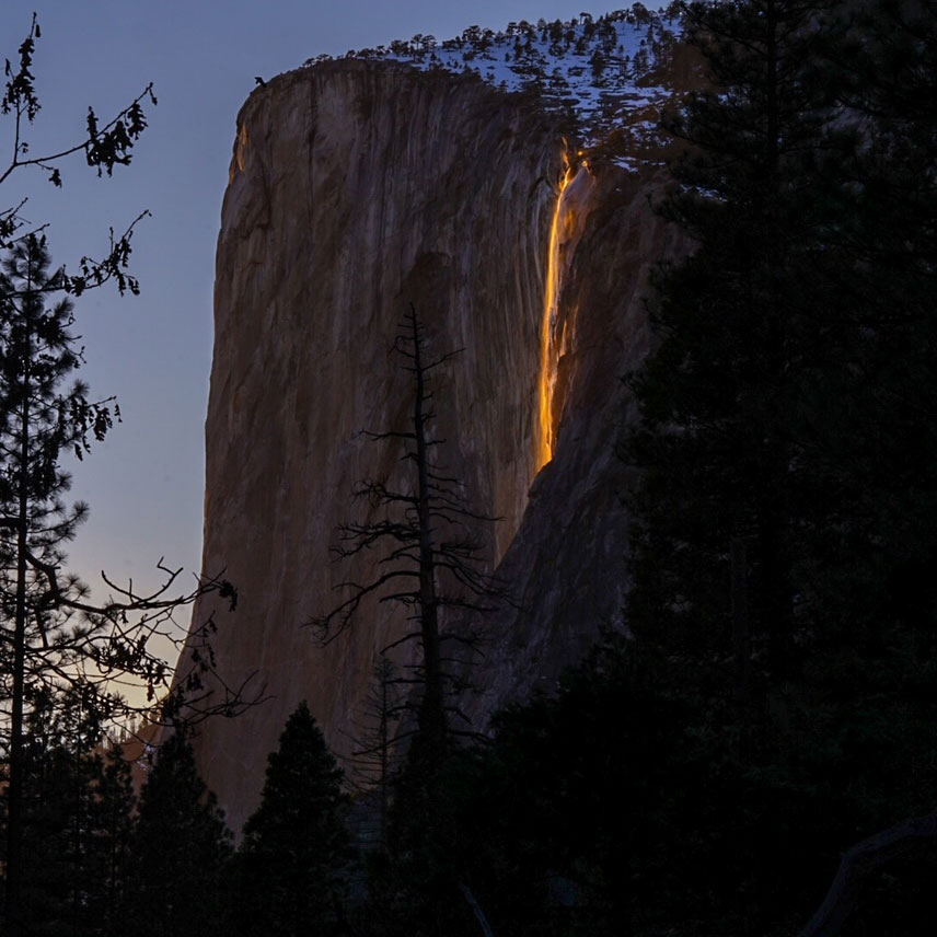
Just below it, also in Yosemite Valley, is Horsetail Fall at 1,570 feet. For most of the year it is an easy-to-overlook seasonal stream on the east face of El Capitan, but for roughly two weeks in mid-to-late February — when snowmelt is flowing and the late-afternoon sun strikes it at the right angle under clear skies — it can light up orange and red, the famous 'firefall' effect. As a horsetail-type fall, the water stays in contact with the rock as it descends, and the 1.5-mile trail to the viewing area gets crowded during the brief February window.
The third member of the four-figure club is the most instructive about measurement. Crabtree Falls in Virginia, on Crabtree Creek in the George Washington National Forest, is frequently called the tallest waterfall east of the Mississippi at about 1,000 feet. That number is a cumulative cascade height — a chain of five major drops and many smaller ones spread across a steep 3.4-mile (round-trip) hiking trail with overlooks at each tier. No single sheet of water plunges anywhere near 1,000 feet here, which is exactly why the East-versus-West 'tallest' debate never fully resolves: it depends on whether you're counting plunges or whole cascades. Spring snowmelt and rain (April through June) bring it to full force.
The 500-to-800-Foot Tier
Below the giants, the field gets crowded and the rankings get close enough that 'approximate' becomes the operative word. Amicalola Falls in Georgia leads this tier at 729 feet, a tiered waterfall on Amicalola Creek inside Amicalola Falls State Park near Dawsonville — and the tallest cascading waterfall in the southeastern United States. It is also one of the most accessible big falls in the country, with viewing options ranging from roadside pullouts to a short staircase climb of about a mile round trip. Spring and the days after heavy rain (March through May) are peak flow.
Two waterfalls tie at exactly 620 feet, and they make a clean compare-and-contrast. Multnomah Falls in Oregon's Columbia River Gorge (Columbia River Gorge National Scenic Area, USFS) is a two-tiered fall on Multnomah Creek with a famous footbridge spanning the gap between drops; it flows year-round, peaks in winter and spring, and is reachable on a 0.2-mile paved path right off the historic highway. Bridalveil Fall in Yosemite, at the same 620 feet, is a single plunge on Bridalveil Creek that catches sidewinds and feathers into mist — the 'veil' of its name — reached by a short 0.5-mile walk. Same number, completely different waterfall: one is stacked, one is a single free fall.
Close behind sit two more snowmelt-driven drops. Utah's Bridal Veil Falls near Provo, a tiered fall of about 607 feet on a Provo River tributary, is essentially roadside (a 0.3-mile path) and one of the easiest tall waterfalls in the West to visit. Nevada Fall in Yosemite, 594 feet, is a powerful horsetail on the Merced River itself — a much larger volume of water than the creek-fed falls around it — and it demands a real effort, a 5.4-mile (round-trip) climb on the Mist Trail or John Muir Trail. Late spring (May through June) is when the Merced runs hardest.
Rounding out the tier, Bird Woman Falls in Montana's Glacier National Park drops 560 feet as a horsetail off a hanging valley high above the Going-to-the-Sun Road. It is technically roadside in that you view it from the road, but it hangs across a valley rather than beside the pavement, fed by snowmelt that peaks late (June through July) in Glacier's short alpine season.
The 350-to-450-Foot Tier
This band is where Hawaii's tropical falls join the ranking and where access ranges from a paved stroll to a helicopter charter. ʻAkaka Falls on the Big Island leads at 442 feet, a sheer plunge on Kolekole Stream inside ʻAkaka Falls State Park near Honomū, managed by Hawaii's Division of State Parks. A short 0.4-mile loop through rainforest delivers you to the overlook. Because it is rain-fed in a wet windward climate rather than snowmelt-fed, there is no single 'best season' — it runs year-round, swelling after heavy rain.
Whitewater Falls in North Carolina follows at 411 feet, billed as the highest waterfall in the eastern United States as a series of plunges — another reminder that 'highest in the East' has several answers depending on method, and Whitewater claims the title on the strength of its dramatic stair-stepped drops rather than a single sheet. On the Whitewater River in the Nantahala National Forest near Sapphire, it is reached by a paved 0.6-mile path and runs strongest with spring snowmelt and after heavy rain (March through May).
Two Hawaiian falls tie at 400 feet with opposite personalities. Waimoku Falls in Haleakalā National Park on Maui is a tall, thin plunge on Pīpīwai Stream at the end of a stunning 4-mile (round-trip) hike through a bamboo forest in the Kīpahulu district — earned, but reachable on foot. Mānāwaiopuna Falls on Kauaʻi, better known as the 'Jurassic Falls' from its on-screen cameo, is the same 400 feet but sits on private land with no public trail; reaching it is backcountry-only, in practice a helicopter or permitted-access affair. Same height, wildly different difficulty — a good illustration that a height ranking says nothing about how hard a waterfall is to see.
Colorado's Bridal Veil Falls near Telluride closes the tier at 365 feet, the tallest free-falling waterfall in Colorado, plunging off a cliff at the head of the box canyon above town. The historic power station perched at its lip is privately held (Idarado Mining Company), with the surrounding terrain in the Uncompahgre National Forest area; a steep 3.6-mile (round-trip) jeep road and trail climb to the top. Snowmelt drives it from May into June.
Just Under: The 300-Foot Range
At the bottom of this particular ranking — though 'bottom' is relative when you're still talking about a 300-foot wall of water — is Comet Falls in Washington's Mount Rainier National Park. It drops about 320 feet as a tiered fall on Van Trump Creek, and the comparison with the entries above it is the whole point: at 320 feet it is roughly half the height of Bridalveil's 620-foot plunge, yet it requires more effort than many taller falls on this list, a 3.8-mile (round-trip) climb that only becomes snow-free in summer. Peak flow comes late, with summer snowmelt from July through September feeding it off Rainier's glaciers.
Comet Falls earns its place here as the floor of a list that could, in truth, run far longer. The United States has hundreds of documented waterfalls taller than 200 feet, and the deeper you go, the blurrier the rankings get — partly because more falls cluster within a few feet of each other, and partly because the smaller and more remote a waterfall is, the less likely anyone has surveyed it precisely. Many widely repeated heights for backcountry falls trace back to a single rough estimate that has been copied for decades.
If there's one takeaway from running these fifteen waterfalls down the ladder, it's that the order is real but the gaps are softer than the numbers suggest. A 411-foot 'highest in the East' and a 400-foot Hawaiian plunge are, for all practical purposes, the same height, and which one ranks above the other can flip depending on whose measurement you trust. Treat this list as a well-sourced tour of America's tallest documented falls — confident at the extremes, appropriately humble about the close calls in the middle.