How We Rank, and Why Heights Are Slippery
This is a ranking of the tallest waterfall we have on record in each state we cover, ordered from highest to lowest. "Tallest" sounds like it should be a settled number, but waterfall height is one of the least standardized measurements in American geography. The U.S. Geological Survey's Geographic Names Information System (GNIS) catalogs the names and locations of features but rarely publishes an official drop height; the National Park Service, the U.S. Forest Service, state park agencies, and independent catalogs like the World Waterfall Database each measure differently, and they frequently disagree.
The core problem is definitional. A single uninterrupted plunge is easy to picture and relatively easy to measure. But many of America's "tallest" waterfalls are tiered or cascading systems where water descends in several steps separated by pools, ledges, or stretches of sloped bedrock. Do you measure the biggest single drop, or the cumulative elevation lost from the top of the first step to the bottom of the last? The answer can change a waterfall's listed height by hundreds of feet, and it is the single biggest reason published figures conflict.
Throughout this ranking we use the height on record for each waterfall and flag the cases where that number is genuinely contested. We lean on the type classification — plunge, tiered, cascade, horsetail, fan, block, segmented — because the type tells you how to read the height. A 320-foot plunge like Mount Rainier's Comet Falls is a very different thing from a 1,000-foot cascade system like Virginia's Crabtree Falls, even though both numbers are real. Treat every figure here as a reasonable best estimate from the managing agency or a respected survey, not a surveyed-to-the-foot certainty.
The Western Giants: California, Oregon, Utah, Montana
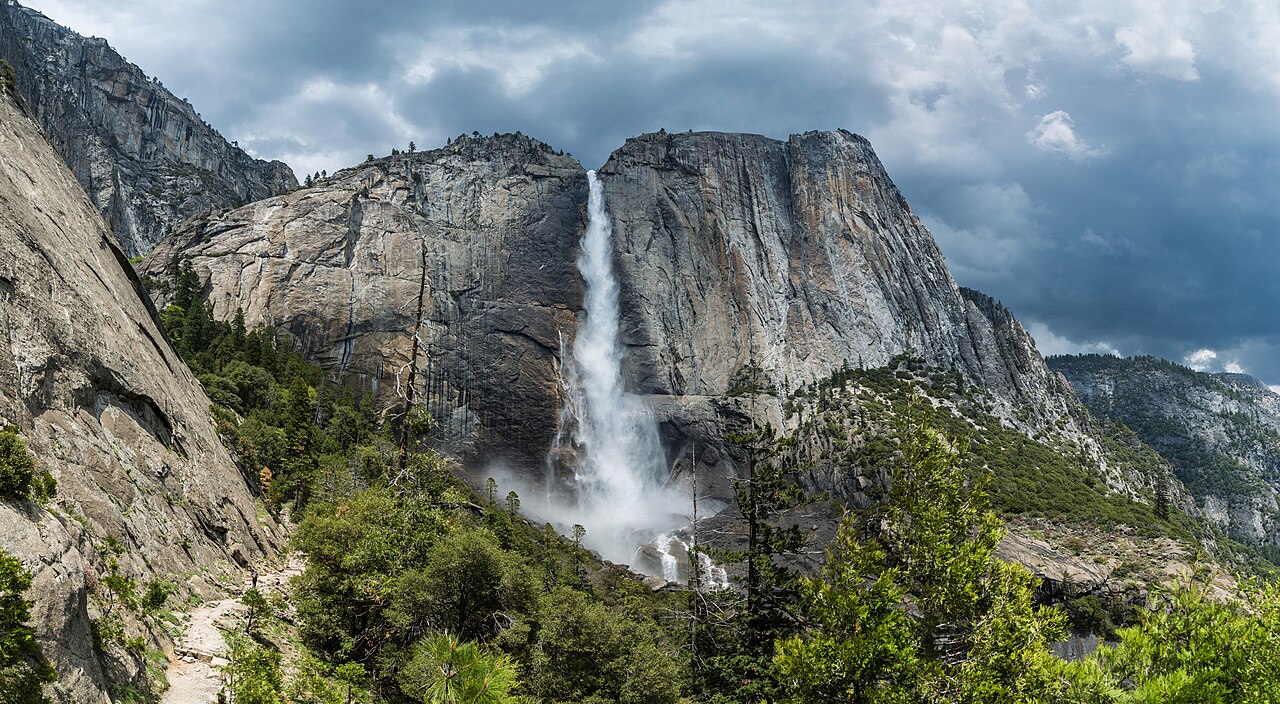
California's Yosemite Falls tops not just this list but, by the common measurement, the entire continent. Its 2,425-foot total drop is the figure the National Park Service and the World Waterfall Database both use, and it is why Yosemite Falls is routinely called the tallest waterfall in North America. But that 2,425 feet is a cumulative number across a three-part system: an Upper Fall of about 1,430 feet, a stretch of middle cascades of roughly 675 feet, and a Lower Fall of about 320 feet. The dominant Upper Fall alone — more than half the total — is the single drop that makes Yosemite Falls genuinely extraordinary. Fed by Yosemite Creek, the falls peak with the spring snowmelt from April through June and can slow to a trickle or vanish entirely by late summer. The strenuous 7.2-mile Upper Yosemite Fall Trail climbs to the brink; the lower viewing area is a short, flat walk from the valley floor.
Oregon's Multnomah Falls, at 620 feet, is the most-visited natural attraction in the Pacific Northwest and one of the most photographed waterfalls in America. The 620-foot figure dates to a 1916 USGS measurement and is the one the U.S. Forest Service, which manages the falls within the Columbia River Gorge National Scenic Area, still uses. Even here the number is contested at the margins: the World Waterfall Database lists it around 635 feet, depending on whether you count an upper cascade and the small "Little Multnomah" drop above the main tier. Multnomah is fed by Multnomah Creek, flows year-round, and is reachable by a paved 0.2-mile path to the Benson Footbridge that spans the gap between its 542-foot upper and 69-foot lower tiers.
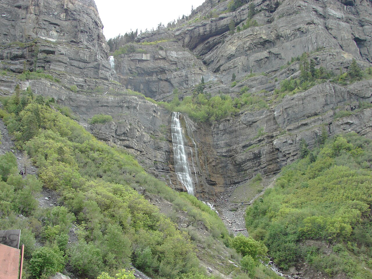
Utah's Bridal Veil Falls near Provo drops 607 feet in tiers down a canyon wall, fed by a Provo River tributary, and is essentially roadside — a 0.3-mile walk puts you at its base. Montana's tallest on our record is Bird Woman Falls in Glacier National Park, a 560-foot horsetail that streams off a hanging valley high above the Going-to-the-Sun Road. There is no trail to its base; you view it from pullouts along the road, and it shows best during the late-spring and early-summer snowmelt in June and July, when the high country finally thaws.
These four share a defining western trait: they are snowmelt-driven and seasonal. The wall of water you see in a June photograph is not what you will find in September. Plan around the runoff if the height is the reason you are going.
The 300-to-450-Foot Tier: Hawaii, the Carolinas, Colorado, Washington, Wyoming
Hawaii's ʻAkaka Falls is the outlier of this group and the most reliable. A 442-foot plunge of Kolekole Stream on the Big Island, it is fed by tropical rainfall rather than snowmelt, so it runs hard year-round without a defined "best season." A 0.4-mile loop trail through ʻAkaka Falls State Park, managed by Hawaii's Division of State Parks, delivers you to the overlook.
North Carolina's Whitewater Falls is one of the most-claimed titles in the East. The Forest Service lists the Upper Falls at 411 feet and calls it the highest waterfall east of the Rockies. That claim is genuinely disputed on two fronts: some surveys argue the true drop is closer to 350-400 feet, and rival waterfalls — Crabtree Falls in Virginia, Amicalola Falls in Georgia — stake competing claims depending on whether you count cumulative cascade height or a single plunge. What is not disputed is that Whitewater is a tiered descent of the Whitewater River in the Nantahala National Forest, reachable by a paved 0.6-mile path to an upper overlook. Its lower tier continues across the state line into South Carolina.
Colorado's Bridal Veil Falls above Telluride is the state's tallest free-falling waterfall, a 365-foot plunge of Bridal Veil Creek with a historic hydroelectric power station perched at its lip — note that the land is largely private (Idarado Mining Company) within Uncompahgre National Forest country, so respect posted access. Washington's tallest on our record is Comet Falls in Mount Rainier National Park, a 320-foot tiered drop of Van Trump Creek reached by a steady 3.8-mile round-trip hike that is typically snow-free only in summer. Wyoming's entry is the most famous of the group: the Lower Falls of the Yellowstone River, a 308-foot plunge that is more than twice the height of Niagara and the centerpiece of the Grand Canyon of the Yellowstone. A short 0.7-mile descent to Brink of the Lower Falls puts you at the edge of the drop; peak runoff comes in May and June.
The Eastern and Plains Standouts: New York to Arkansas
New York's Kaaterskill Falls is a 260-foot two-tiered waterfall on Spruce Creek in the Catskills, a landscape so painted and written about in the 19th century that it helped launch American landscape art. The NYSDEC manages it within Catskill Park, and a 1.4-mile hike reaches the viewing areas. Tennessee's Fall Creek Falls, by contrast, is a single clean 256-foot plunge of Cane Creek and is frequently cited as the tallest free-falling waterfall east of the Mississippi — a narrower, more defensible claim than the cumulative-cascade titles, precisely because it is one uninterrupted drop. It runs best in winter and spring after rain (December through April) and is an easy 1-mile walk in Fall Creek Falls State Park.
Idaho's Shoshone Falls breaks the height pattern in the most spectacular way. At 212 feet it is shorter than several waterfalls below it would be in raw plunge terms, but it is a 900-foot-wide block waterfall on the Snake River — taller than Niagara and nicknamed the "Niagara of the West." Its flow is governed by upstream irrigation demand, so the dramatic version appears during spring snowmelt and reservoir releases from April through June; in late summer it can run nearly dry. It is essentially roadside in Twin Falls' Shoshone Falls Park.
Arkansas closes out the 200-foot club with Hemmed-In Hollow Falls, at 209 feet the tallest waterfall between the Rockies and the Appalachians. It is a rain-dependent plunge in the Buffalo National River wilderness, which is the catch: there is no watercourse that runs reliably, so it is a thread or nothing outside the wet season. Reaching it is a serious 5-mile round-trip hike, best attempted late winter to spring after rain. Arizona's Mooney Falls (200 feet) is the most committing on this entire list — a turquoise Havasu Creek plunge on Havasupai Tribe land, 22 miles into the backcountry with a permit required, descended via chain-and-ladder sections cut into travertine. It is a destination, not a stop.
The Midwest, Mountain West, and Northeast: 60 to 165 Feet
Below the 200-foot mark, the ranking becomes a tour of regional champions — the tallest in their state, even if modest on a national scale. Wisconsin's Big Manitou Falls (165 feet) on the Black River in Pattison State Park is the tallest waterfall in the state and one of the highest east of the Rockies, reachable by a short 0.5-mile walk. New Hampshire's Arethusa Falls (140 feet) is a graceful fan of Bemis Brook in Crawford Notch State Park, a 3-mile round-trip through the White Mountains. Missouri's Mina Sauk Falls (132 feet), a tiered drop of Taum Sauk Creek, sits on the state's highest peak and runs best in spring after rain.
Vermont's Lye Brook Falls (125 feet), a cascade in the Green Mountain National Forest's Lye Brook Wilderness, rewards a 4.5-mile round-trip. Minnesota's High Falls of the Pigeon River (120 feet) is a powerful block waterfall on the U.S.–Canada border, jointly managed by the Minnesota DNR and the Grand Portage Band, with a 1-mile walk to the overlook. New Mexico's Nambe Falls (120 feet), on Nambe Pueblo land along the Rio Nambe, ties it. Michigan's Laughing Whitefish Falls (100 feet) and Pennsylvania's Bushkill Falls Main Falls (100 feet) round out the triple-digit group — the latter privately owned and laced with boardwalks earning it the "Niagara of Pennsylvania" nickname.
From there the regional champs run smaller and the seasonal and access caveats matter more. Maine's Moxie Falls (90 feet), Nevada's Galena Creek Falls (82 feet), Oklahoma's Turner Falls (77 feet, the tallest in the state on Honey Creek), Texas's spring-fed Gorman Falls (70 feet in Colorado Bend State Park, one of the few here that runs reliably year-round), West Virginia's Falls of Hills Creek Lower Falls (63 feet), South Dakota's Spearfish Falls (60 feet), and Massachusetts's Bash Bish Falls (60 feet, a distinctive segmented drop split by a central boulder) each hold the height crown for their state in our records. None will rival Yosemite, but each is the genuine local maximum — and several, like Gorman and Bash Bish, are far easier to reach and more dependable than the marquee giants.
One state on our list has no recorded height at all: South Carolina's Raven Cliff Falls, a tiered drop of Matthews Creek in Caesars Head State Park, is widely described as one of the tallest in the East but lacks a single agreed-upon, well-documented figure — a fitting reminder of how unsettled waterfall measurement remains. We list it because it is clearly the state's standout, while declining to invent a number the sources do not support. The 4.4-mile round-trip to the suspension-bridge overlook is the honest way to judge its scale for yourself.