What 'roadside' really means (and why heights are slippery)
Every waterfall on this list shares one trait: you can see it without a meaningful hike. In our data each is tagged roadside, meaning the falls are visible from a road, an overlook, or after a short walk on the order of a few hundred feet. The recorded trail distances bear that out — Snoqualmie Falls in Washington logs about 0.1 mile from lot to viewing deck, Salt Creek Falls in Oregon about 0.2 mile, Bridal Veil Falls in Utah about 0.3 mile, and several Hawaii overlooks have no trail at all because the view is from the pullout itself. That makes this a list built for families with strollers, travelers with limited mobility, and anyone who wants a genuine wow on a road trip without rearranging the day.
A word on the numbers before we start. Reported waterfall heights vary a lot depending on who measured and how. Some figures describe a single clean plunge; others add up every tier and cascade into one cumulative total. Bird Woman Falls in Glacier is a good example — our data lists 560 feet, which matches the most commonly cited figure, but you will find sources quoting everything from under 500 feet to nearly 1,000 feet for the full chain of drops. We use the height in our records and flag it as approximate rather than pretending any one figure is definitive. When a number here disagrees with a roadside plaque, both can be 'right' for different definitions.
We have also sorted this guide roughly by height, from tallest to shortest, but height is not the same as impact. A 97-foot waterfall at peak snowmelt with the road right beside it can outshine a 200-footer reduced to a trickle in late summer. Volume, season, and how close you can stand matter as much as the drop. Read the seasonal notes for each — they are the difference between a postcard and a disappointing gravel pullout.
The giants: 500-foot drops you can see from the pullout
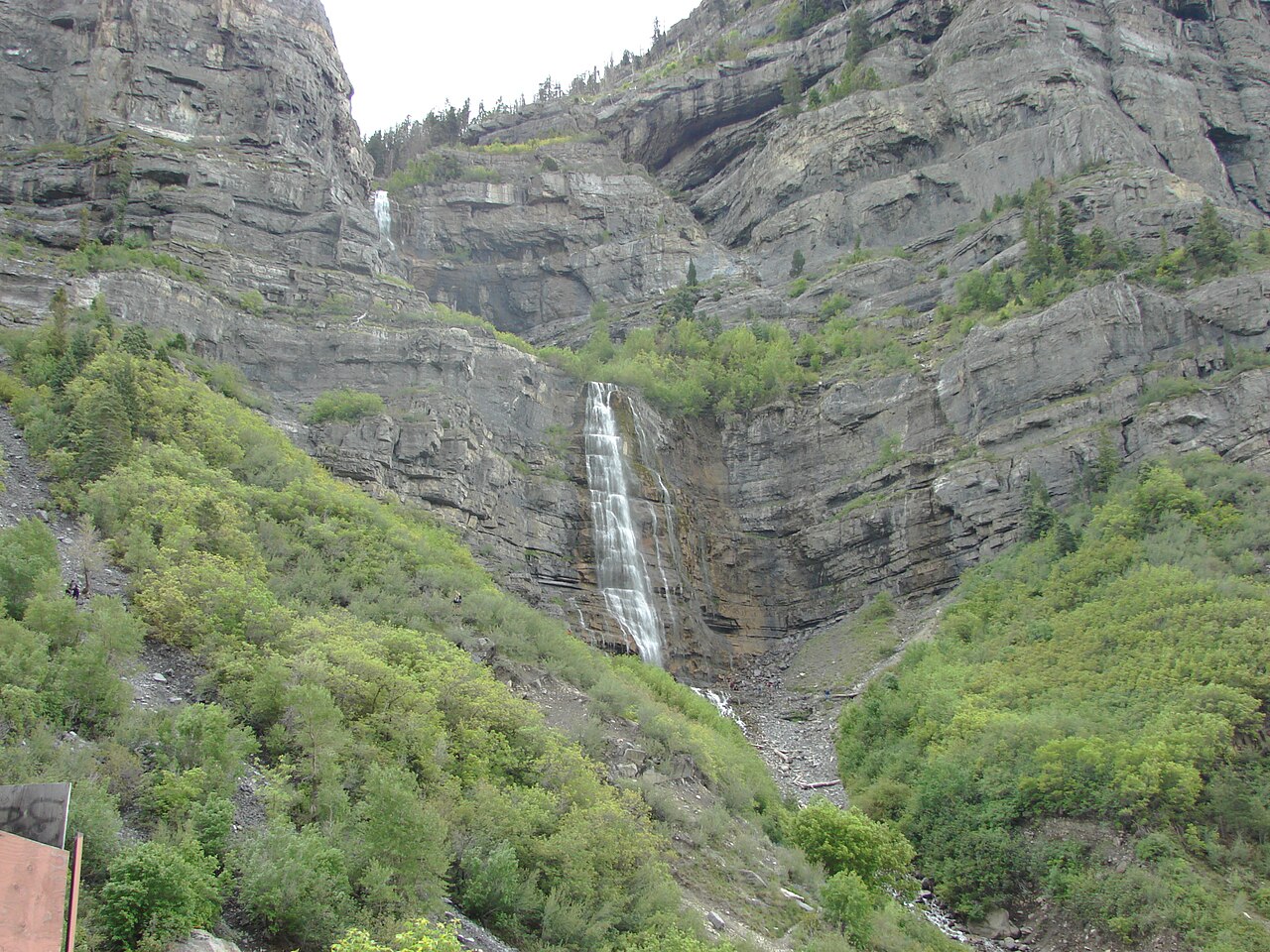
Two waterfalls on this list clear 500 feet, and both are essentially drive-up views. Bridal Veil Falls near Provo, Utah, is the tallest at a recorded 607 feet, a tiered cascade fed by a Provo River tributary in Provo Canyon. It sits within the Uinta-Wasatch-Cache National Forest area and is managed locally by Utah County; a paved path of roughly 0.3 mile leads from the parking area to the base. Time your visit for spring snowmelt, April through June, when the canyon's runoff turns the falls into a full-width sheet of water. By late summer the flow thins considerably.
Montana's Bird Woman Falls is the other titan, recorded at 560 feet, a horsetail-form fall on a tributary of Logan Creek inside Glacier National Park. Crucially, you do not hike to it — you view it across the valley from pullouts along the Going-to-the-Sun Road, with the falls readily visible from roughly two miles away on the road's western stretch. That distance is also why timing is everything: Bird Woman's flow peaks with late-spring and early-summer snowmelt, June into July, and can dwindle to almost nothing by autumn. The Going-to-the-Sun Road itself is seasonal, so confirm it is open before you plan around it; the National Park Service posts current road status every year.
Both of these reward patience with light. Bridal Veil faces such that morning sun lifts it out of canyon shadow, while Bird Woman, set high between Mount Oberlin and Mount Cannon, is best when the sun is across the valley rather than behind it. Neither asks more of you than a parked car and a short stroll, which is remarkable for waterfalls this size.

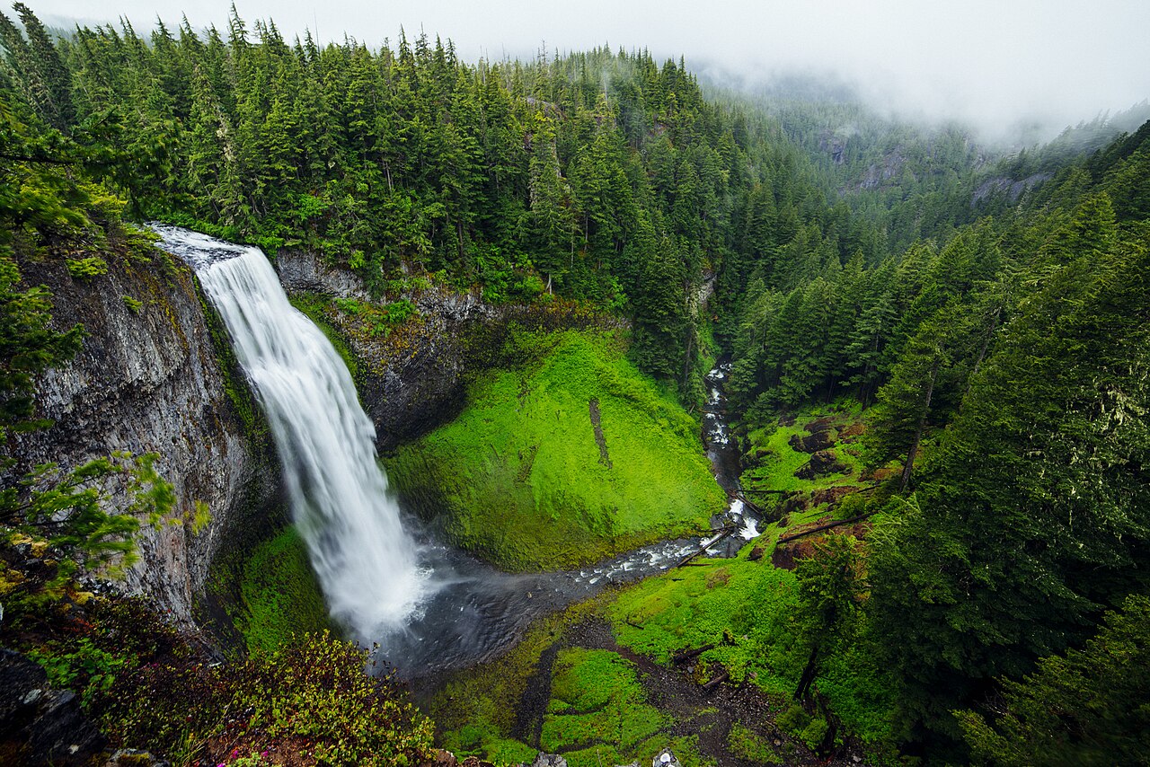
The big-water classics: Snoqualmie, Salt Creek, Shoshone, and Niagara
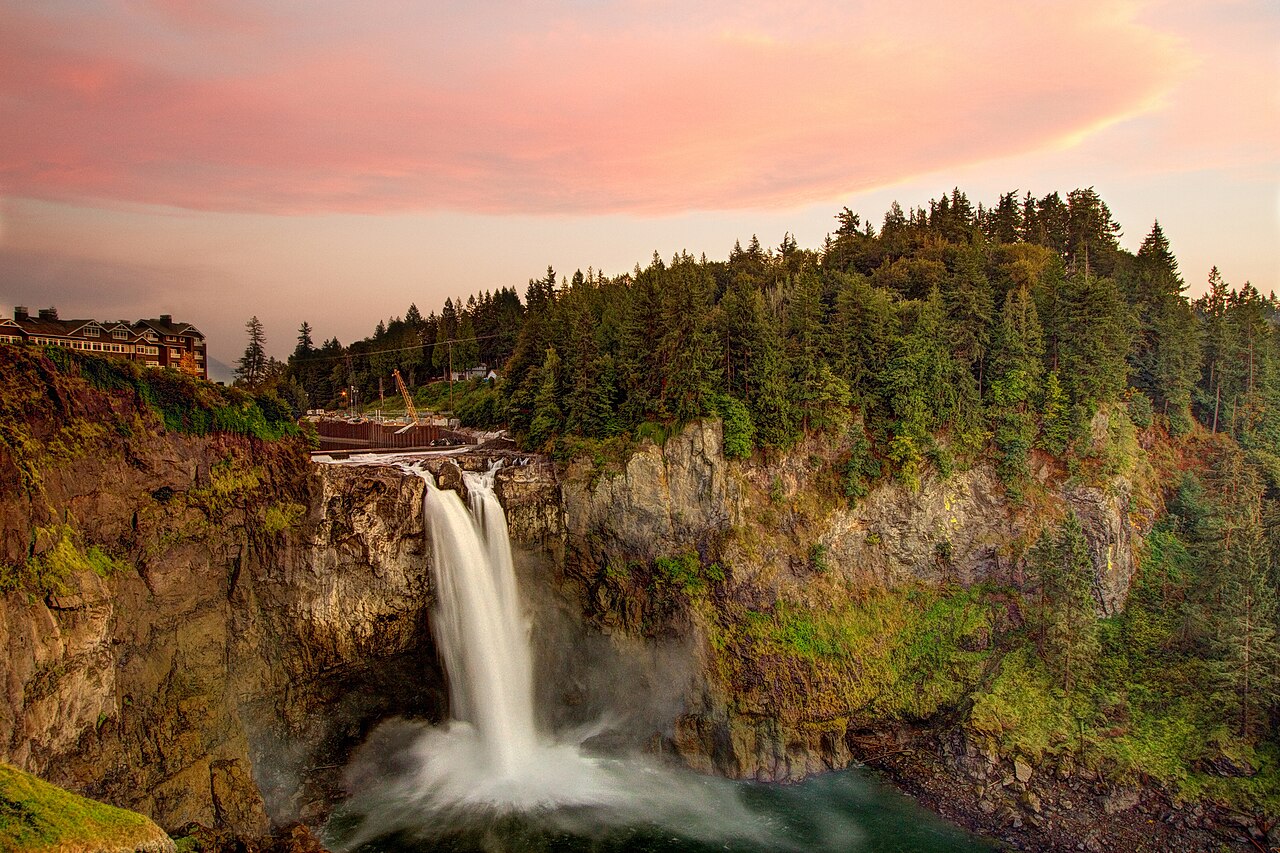
Snoqualmie Falls in Washington is the gold standard for accessible viewing: a 268-foot plunge on the Snoqualmie River with a free, dawn-to-dusk viewing park. The upper observation deck sits roughly 200 feet from the parking lot and is wheelchair accessible, and because the falls power a working hydroelectric plant operated by Puget Sound Energy, they flow year-round — no waiting for a snowmelt window. Winter and spring, November through May, bring the highest volume, but this is one of the few entries here that genuinely delivers in any season.
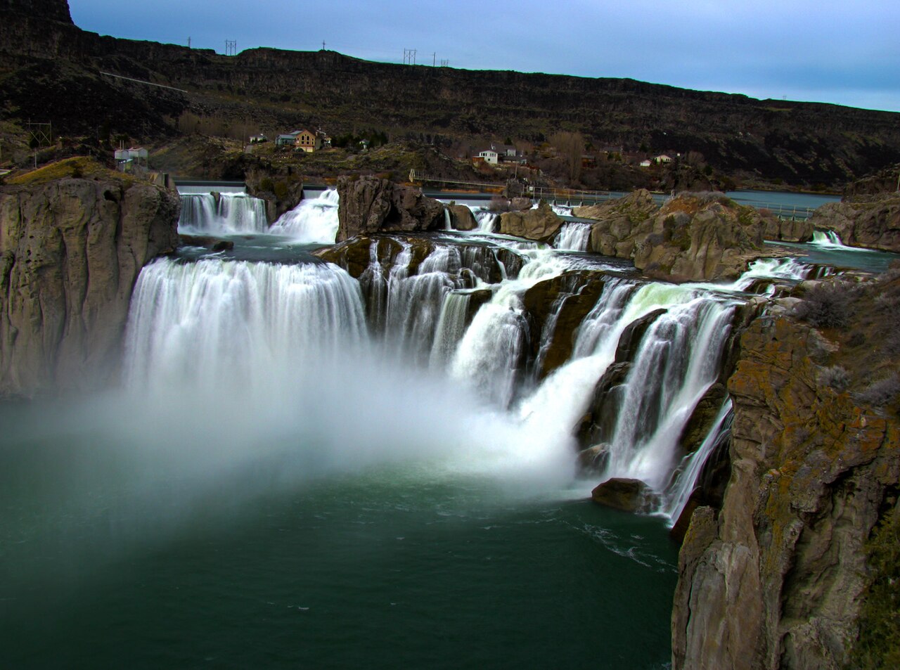
Oregon's Salt Creek Falls, a 286-foot plunge in the Willamette National Forest, is among the tallest in the state and lies just off Highway 58, about 0.2 mile from the parking area to the overlook. It runs strongest with late-spring snowmelt, May into June. Far to the south, Idaho's Shoshone Falls earns its nickname 'Niagara of the West': at a recorded 212 feet it actually stands taller than Niagara's drop, spanning the Snake River near Twin Falls in a city-run park about 0.2 mile from the lot. Its appearance changes dramatically with flow — a single roaring block at high water in spring, splitting into several separate ribbons when reservoir releases and snowmelt taper off, so April through June is the window to catch it full.
And then there is the namesake itself. Niagara Falls — the combined Horseshoe and American Falls — straddles the Niagara River at the New York–Ontario line, with the U.S. side anchored by Niagara Falls State Park, the oldest state park in the country. The recorded drop is about 188 feet, but the spectacle is the sheer volume of the Niagara River pouring over a wide rim. Viewing platforms are steps from parking and walkways, it flows every day of the year, and peak flow runs late spring through summer. It is the least 'hidden' waterfall imaginable, but it remains the benchmark for what roadside grandeur can be.
Eastern overlooks: Toccoa, Letchworth's Middle Falls
In northeast Georgia, Toccoa Falls is a 186-foot plunge on Toccoa Creek — taller than Niagara's drop — and one of the most easily reached tall waterfalls in the Southeast, a walk of only about 0.1 mile from the parking area. One important caveat: the falls sit on the campus of Toccoa Falls College, which is private property. Access is generally permitted for a small fee through the college's gift store, but hours and entry rules are set by the school, so check before you go rather than assuming it is a public park. Toccoa is at its best in spring and after heavy rain, March through May, when the creek has water to spare; in dry spells it can slim to a thread down the rock face.
New York's Letchworth State Park — the 'Grand Canyon of the East' — holds the Middle Falls of the Genesee River, recorded at 107 feet and widely considered the most photographed waterfall in the state. A short paved path, roughly 0.3 mile, links the parking area to the overlooks above the gorge, where the river spreads nearly 300 feet wide before dropping. The gorge walls rising hundreds of feet on either side are half the drama. Spring snowmelt, April through June, brings the Genesee up to full force, and the surrounding park makes an easy half-day even if the falls were the only reason you came.
Both of these belong on a road-trip itinerary precisely because they ask so little. Toccoa is a quick detour off the highway corridors of northeast Georgia, and Letchworth's Middle Falls is one of three major falls in a single state park, so a few minutes of walking buys you a lot of waterfall.
Hawaii's drive-up overlooks and two important asterisks
Kauai offers two of the most effortless waterfall views in the country, both on the island's east side. Wailua Falls, a segmented fall recorded at 173 feet on the South Fork of the Wailua River, is viewed from a short paved, accessible overlook at the end of Maalo Road north of Līhuʻe — famous as the waterfall in the opening credits of the old television series 'Fantasy Island.' A few minutes away, ʻŌpaekaʻa Falls is a 151-foot plunge on ʻŌpaekaʻa Stream, seen from a roadside lookout along Kuamoʻo Road with parking, picnic tables, and restrooms right there. Neither requires a trail; the view is from the pullout. As tropical falls, both run year-round, fed by frequent rain rather than a single snowmelt season, though they swell noticeably after heavy storms. A safety note that applies island-wide: do not scramble below these overlooks — the terrain is steep, wet, and has injured people who left the railings.
Two entries on this list come with genuine access asterisks, and honesty matters more than a tidy itinerary here. Arizona's Grand Falls — the 185-foot tiered 'Chocolate Falls' on the Little Colorado River, named for the mud-brown snowmelt that gives it color — sits on Navajo Nation land near Flagstaff and historically drew crowds during its brief March-to-April flush. As of recent reporting, Grand Falls has been closed to non-Navajo visitors. Local Navajo communities moved to close the site over trespassing, trash, damage to sacred areas and gravesites, and general disrespect; Navajo Nation lands also require a permit from the tribe's Parks and Recreation Department. Treat Grand Falls as off-limits unless and until the Leupp Chapter and Navajo Nation Parks reopen it and you hold a valid permit. It is a remarkable waterfall, but the right call right now is to admire it from afar and respect the closure.
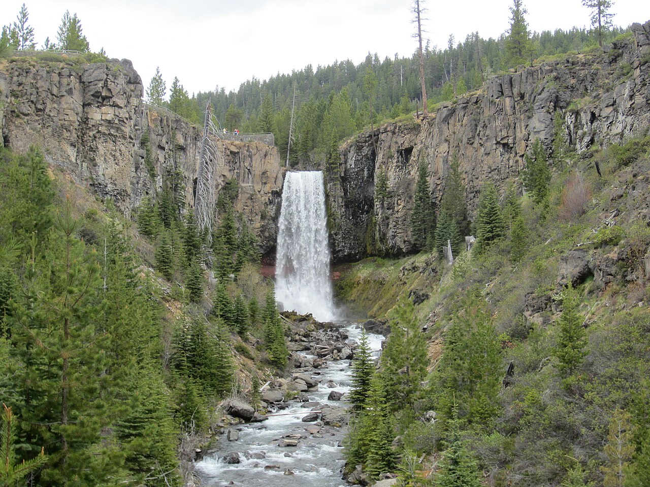
Oregon's Tumalo Falls near Bend carries a milder asterisk: it is genuinely a drive-up view in season — the overlook is just steps from the parking lot on Forest Road 4603 in the Deschutes National Forest — but the access road is gated against vehicles roughly November through May because of snow. In those months the falls become a multi-mile snowshoe or ski from the Skyliner Sno-Park, which is no longer 'roadside.' Plan Tumalo for the snow-free stretch, roughly June through September, when the recorded 97-foot plunge is a one-minute walk from the car. Always confirm the gate is open with the Deschutes National Forest before driving up.
How to plan a roadside-waterfall stop that actually pays off
Start with season, not distance. The single biggest variable for most of these falls is water volume, and volume tracks the source. Snowmelt-fed falls — Bridal Veil, Bird Woman, Salt Creek, Shoshone, Grand Falls, Letchworth's Middle Falls — peak in spring and early summer and fade after. Rain-fed Toccoa is best in spring and after storms. The exceptions that run reliably year-round are the dam- and river-driven ones: Snoqualmie (a working hydro site), Niagara, and Kauai's rain-soaked Wailua and ʻŌpaekaʻa. If your trip is in August, weight your stops toward those year-round performers and lower your expectations for the snowmelt falls.
Confirm access the week you travel. Three of these involve gates, roads, or owners that can close without much notice: the Going-to-the-Sun Road (Bird Woman) is seasonal, Tumalo's forest road is gated in winter, and Grand Falls is currently closed to outside visitors entirely. Toccoa Falls is private campus property with its own hours. The authoritative sources — the National Park Service for Glacier, the U.S. Forest Service for Deschutes and Willamette, the state park system for Letchworth and Niagara, and the managing entity for each privately or tribally held site — post current conditions, and a two-minute check beats a wasted drive.
Finally, manage the small stuff that makes a roadside stop pleasant. Most of these viewing areas are short and paved but can be slick with spray, so flat shoes with grip beat sandals at Snoqualmie, Salt Creek, and the Hawaii overlooks. Mornings tend to mean smaller crowds and better light at the marquee sites like Niagara and Shoshone. And stay behind the railings — the appeal of a roadside waterfall is that you do not need to take risks to see it. Pull over, walk the few hundred feet, and let the water do the work.