Why Glacier is a waterfall park (and a note on heights)
Glacier National Park sits across the Continental Divide in northwest Montana, and almost every waterfall here owes its existence to ice. During the last glaciation, alpine glaciers ground out broad U-shaped main valleys while smaller side glaciers carved shallower tributary valleys. When the ice melted, those side valleys were left stranded high on the walls of the main valleys — geologists call them hanging valleys — and the creeks draining them now have nowhere to go but over the lip. That single fact explains the park's signature waterfall: a thin, tall ribbon pouring off a cliff face, fed by snow and ice rather than a large river. Bird Woman Falls, dropping a reported 560 feet from a hanging valley between Mount Oberlin and Clements Mountain, is the textbook example.
Because the water is snowmelt, timing matters more here than in most waterfall regions. The high country holds deep snow into June, and the same snowpack that closes the alpine section of Going-to-the-Sun Road until late June or July is what feeds the falls. That makes late spring and early summer — roughly June into July — the loudest, fullest window for the high snowmelt falls, while the lower, creek-fed falls near St. Mary and Two Medicine run more reliably through the summer. By late August, many of the thin hanging-valley ribbons have shrunk to a trickle.
A word on the numbers, because waterfall heights in Glacier are slipperier than they look. The 560 feet often cited for Bird Woman Falls is a measurement of a tall, broken cliff descent, not one clean plunge, and different sources disagree about where to start and stop the count. Smaller falls like Running Eagle (about 40 feet) and St. Mary (about 35 feet) are easier to pin down, but even those vary by a few feet depending on flow and method. Throughout this guide we give the commonly documented figures and flag where a number describes a cumulative or tiered descent rather than a single sheer drop.
This is a curated set of six well-documented falls, chosen for the combination of scenic payoff, public access, and reliable Park Service records — not a complete census. Glacier has dozens of named and unnamed cascades, many of them seasonal and trail-less. If a fall you love isn't here, that's a limit of scope, not a verdict.
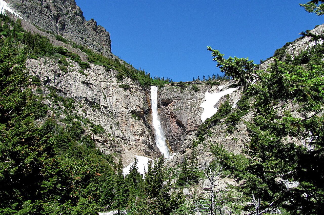
Going-to-the-Sun Road: Bird Woman Falls from the car
The single most photographed waterfall in Glacier is one you never have to hike to. Bird Woman Falls hangs on the north wall of the valley below Logan Pass, visible across the gulf of air from pullouts on the west side of Going-to-the-Sun Road as it climbs toward the pass. The falls plunge from a classic hanging valley tucked between Mount Oberlin and Clements Mountain, draining a snow-filled cirque high above. At a reported 560 feet it is among the tallest documented falls in the park, and because it's a horsetail-type descent — water staying in contact with the rock as it falls — it reads as a long, bright thread against the dark cliff.
The catch is access and timing. The alpine stretch of Going-to-the-Sun Road over Logan Pass is one of the last high mountain roads in the country to open each year; plowing crews routinely don't clear the whole route until late June or July, and the opening date shifts year to year with the snowpack. Until the road opens, you simply cannot reach the viewpoints. Once it does, the same melting snowpack that allowed plowing is feeding the falls, so the window when the road is open and Bird Woman is running hard is essentially late June through July. By late summer the falls thin noticeably, and they can nearly vanish in a dry year.
Practically, this is the easiest 'hike' in the guide — difficulty easy, no trail miles, nearest services in West Glacier on the park's west side. You view it from roadside pullouts, so plan around the road's vehicle-reservation system (Glacier has used timed-entry reservations for the Going-to-the-Sun corridor in recent summers) and the brutal midday parking competition at Logan Pass. Early morning light hits the falls' face and the lot is emptier; bring a telephoto lens, because even though the falls are tall, they're far across the valley.
St. Mary and Virginia Falls: the classic east-side day hike
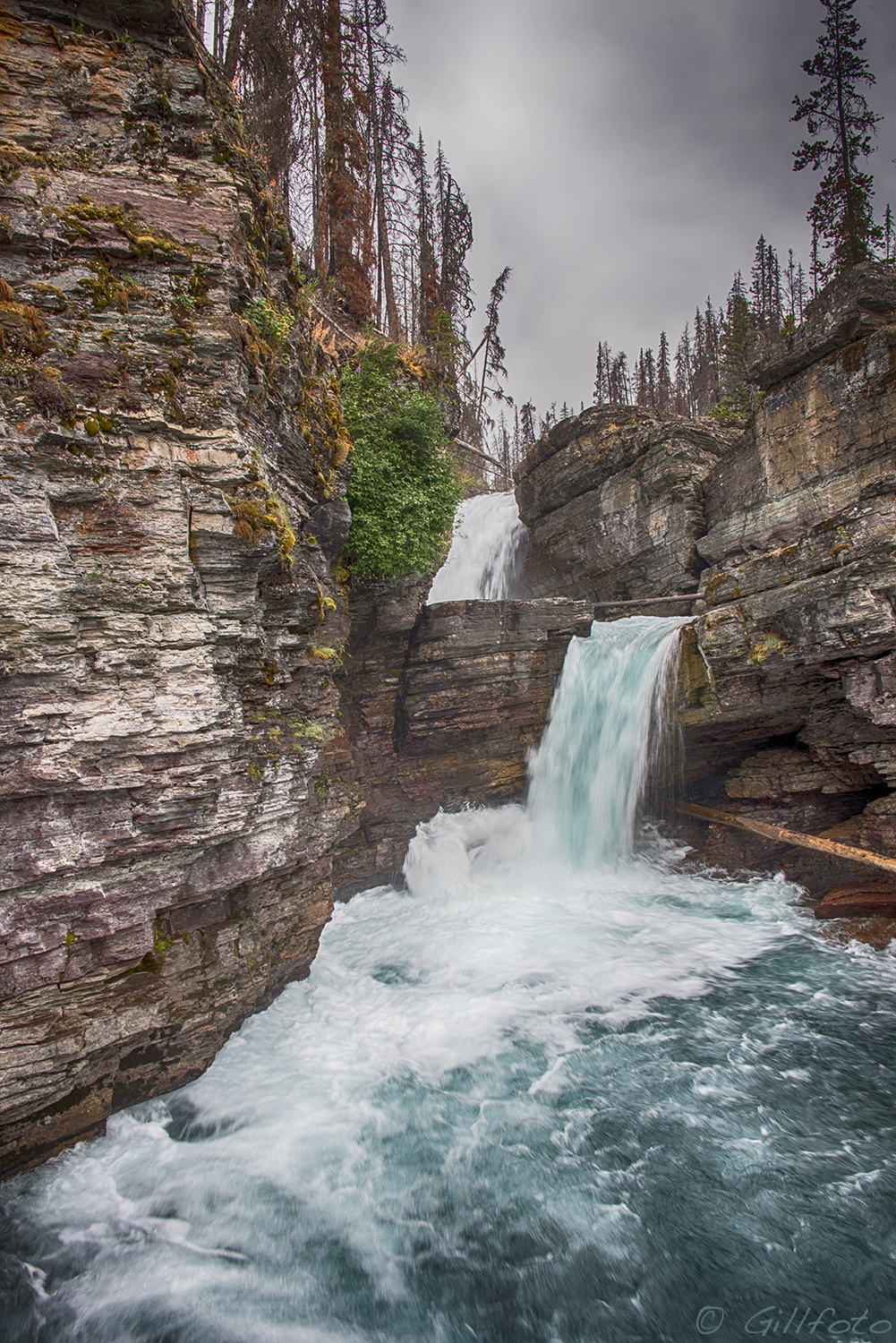
On the park's east side, the trail to St. Mary Falls and Virginia Falls is the most rewarding short waterfall walk in Glacier, packing two distinct falls into one moderate outing. From the St. Mary Falls trailhead off Going-to-the-Sun Road, it's roughly 2.4 miles round trip to St. Mary Falls, a tiered drop of about 35 feet where the St. Mary River squeezes through a rock gorge and pours into an almost cartoonishly turquoise pool. The blue-green color comes from glacial rock flour suspended in the water, and a footbridge puts you right at the lip. The grade is gentle and the footing good, which is why this stretch is rated easy and stays busy all summer.
Push on another mile or so up Virginia Creek and you reach Virginia Falls, a taller tiered cascade — the most-cited figure is around 50 feet for the main visible drop, though the creek tumbles in several steps and you'll see water well above and below the main fall. Round trip to Virginia Falls runs about 3.6 miles at a moderate rating, with a modest climb in the final stretch. Many hikers do both as a single loop-ish out-and-back, and on a hot day the spray off Virginia Falls is the reward at the turnaround.
Both falls draw from the St. Mary and Virginia Creek drainages and run dependably from roughly late June through September, making them a safer bet than the high snowmelt ribbons if you're visiting later in the season. The nearest base is the St. Mary entrance and village on the park's eastern boundary. Note that this corridor burned in the 2015 Reynolds Creek Fire, so stretches of the trail pass through open, regenerating forest — more sun exposure, fewer shade breaks, and unobstructed views you wouldn't get under mature canopy. The St. Mary area has also been part of Glacier's vehicle-reservation zones in recent years, so check current entry requirements before you go.
Apikuni and Florence Falls: from a quick climb to a backcountry haul
The Many Glacier valley on the northeast side of the park holds two falls at opposite ends of the effort spectrum. Apikuni Falls is the short, steep one: about 1.6 miles round trip from a trailhead on the Many Glacier Road, climbing to a cascade of roughly 150 feet on Appekunny Creek. The trail is rated moderate mostly because of its grade — it gains elevation quickly across open meadow before reaching the falls — and the reward is a multi-step cascade splashing down a rock face with the Many Glacier peaks at your back. Best flow runs from late June into September as the high snow feeds the creek, and this is prime grizzly country, so the meadow approach is a place to make noise and carry bear spray.
Florence Falls is the serious undertaking in this guide. Reaching it is roughly a 9.5-mile round-trip backcountry trek rated strenuous, following the Piegan Pass / Gunsight area trails to a tiered fall of about 250 feet on Florence Creek. This is a full-day effort with real elevation, exposure, and the logistics of a long Glacier backcountry hike — early start, weather contingency, and bear awareness throughout. The payoff is solitude and scale: a tall, multi-tier cascade most park visitors never see, set deep in the high country well away from the road crowds. The standard window is July through September, after the high passes and trail sections have melted out enough to travel safely.
Because Florence sits so far in, treat it as a hike first and a waterfall second: check current trail status and any closures with the Park Service before committing, confirm the route from the nearest trailhead, and have the navigation, layers, food, and water for a long day. The nearest services are at St. Mary on the east side. If you only have the legs for one of these two, Apikuni delivers a big visual return for under two miles; Florence is for hikers who want the falls as the centerpiece of a backcountry day.
Running Eagle Falls: the two-faced fall at Two Medicine
In the quieter Two Medicine region on Glacier's southeast side sits one of the most unusual waterfalls in the park. Running Eagle Falls — long known by the nickname 'Trick Falls' — is a roughly 40-foot tiered fall on the Two Medicine River drainage that genuinely looks like two different waterfalls depending on the season. In spring, when snowmelt is at its peak, the river roars over the upper lip in a single broad curtain. As the high water drops later in summer, the upper flow shrinks and water instead emerges from a cave-like opening partway down the rock face, so the falls appear to spring from the middle of the cliff. That seasonal switch is the 'trick,' and it's the reason to time a visit deliberately.
It's also the easiest fall in this guide to reach: about a 0.6-mile round-trip walk on a flat, well-graded trail from a trailhead on the Two Medicine Road, rated easy and friendly for families and visitors of most abilities. The short approach and the falls' photogenic double personality make it a favorite quick stop, and Two Medicine's relative remoteness — it's a longer drive from the busy west-side hubs — means it's usually calmer than the Going-to-the-Sun corridor. The name honors a Blackfeet woman warrior, and interpretive signage at the site tells that history; this is land of deep significance to the Blackfeet Nation, whose reservation borders the park's eastern edge.
For the dramatic single-curtain look, come during spring snowmelt, roughly May into June; for the cave-emerging 'trick' look, come in mid-to-late summer once flows drop. The nearest base is East Glacier Park, and because Two Medicine sits in the park's southeast corner it pairs naturally with the Two Medicine Lake area rather than with the St. Mary or Many Glacier circuits.
Planning your waterfall trip: timing, access, and safety
Sequence your visit around two calendars: the road and the snowpack. The alpine section of Going-to-the-Sun Road is the gatekeeper for Bird Woman Falls and the easiest access to the St. Mary–Virginia trailheads, and it typically opens fully only in late June or July. Earlier in the season, the west and east lowland sections may be open while the pass is still closed, which still gets you to Running Eagle (Two Medicine) and the lower east-side falls. For the high snowmelt ribbons like Bird Woman, the sweet spot is the brief overlap when the road is open and the snow is still feeding hard — late June through July. For the creek-fed falls like St. Mary and Virginia, late June through September is reliable.
Reservations and crowds are the other planning reality. Glacier has used timed vehicle-entry reservations for its busiest corridors — the Going-to-the-Sun Road and parts of the east side — during peak season in recent years, and the specifics change annually, so confirm current requirements on the park's official site before you book lodging. Logan Pass parking fills early; for any falls reached from that corridor, an early start is the single biggest quality-of-life improvement you can make. The east-side trailheads (St. Mary, Many Glacier) and Two Medicine each have their own access and reservation nuances worth checking separately.
Finally, take Glacier's hazards seriously. This is grizzly and black bear country across every trail in this guide; carry bear spray, know how to use it, hike in groups, and make noise on the brushy, meadow approaches like Apikuni. Snowmelt-swollen creeks and the slick rock around falls like St. Mary and Virginia cause injuries and deaths every year — stay on marked trails and behind railings, and never wade or scramble above a fall in high water. For long backcountry objectives like Florence Falls, check trail status and closures with the Park Service the day before, start early, and carry the navigation, layers, food, and water for a full alpine day. Conditions shift fast on the Divide.