Why West Virginia Is Waterfall Country
West Virginia earns its waterfalls the hard way. The state sits almost entirely within the Appalachian Plateau and Ridge-and-Valley provinces, where rivers and creeks cut down through layers of resistant sandstone and softer shale. Wherever a hard caprock sits over erodible rock, water finds the edge and the edge becomes a falls. That geology, combined with high annual precipitation and a dense network of public land — the Monongahela National Forest, New River Gorge National Park & Preserve, and a deep bench of state parks and forests — is why a state this small documents so many named drops.
The falls in this guide span a wide range of character. Some, like Cathedral Falls near Gauley Bridge and Valley Falls near Fairmont, are essentially roadside: you park and the water is right there. Others, like the High Falls of Cheat, sit at the end of a 7-plus-mile hike (or a seasonal scenic-railroad ride) deep in the national forest. Heights run from the 12-foot ledges of Mash Fork and Tenskwatawa Falls up to the multi-tiered 63-foot drop at the Falls of Hills Creek. None of these are giants by Western or Pacific Northwest standards — but in the green, layered Appalachian setting, a 35- to 60-foot falls framed by hemlock and rhododendron is a genuinely memorable thing to stand in front of.
A word on the heights you'll see here and elsewhere. Waterfall heights are notoriously inconsistent between sources, because different people measure different things — the single tallest vertical drop, the cumulative height of a tiered cascade, or an eyeballed estimate that never gets corrected. Where this guide lists a number, it reflects commonly documented figures, but treat them as approximate. A 'cascade' that one source calls 20 feet and another calls 35 feet usually isn't a contradiction so much as two people drawing the start and stop lines differently.
The Marquee Falls: Hills Creek, Cathedral, and Blackwater
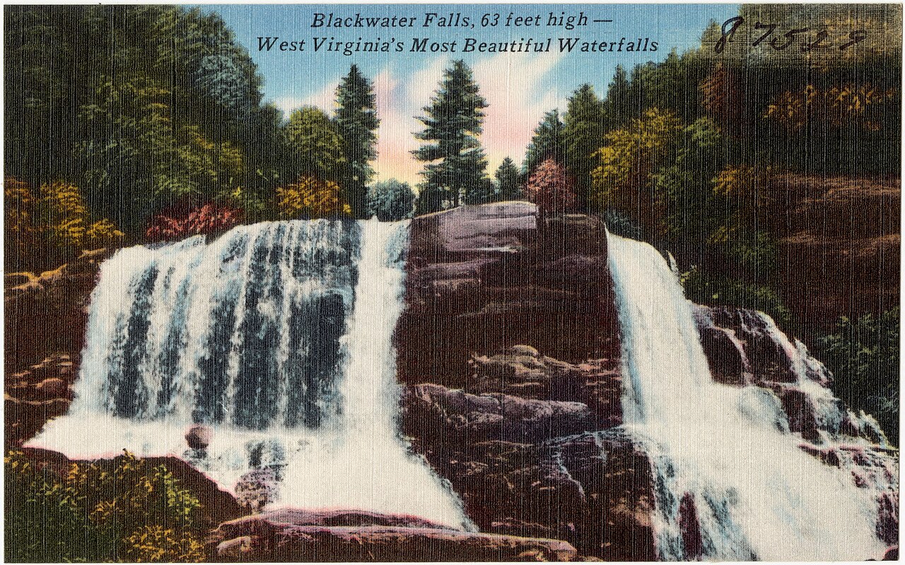
If you only have time for a handful, start with these three. The Falls of Hills Creek, in the Monongahela National Forest near Hillsboro, is the headline attraction — a scenic area where Hills Creek drops through a series of falls, the lowest and largest of which (the Lower Falls) is documented at roughly 63 feet, making it one of the tallest in the state. A boardwalk-and-stairway trail of about 1.4 to 1.6 miles round trip descends through a cool, moss-draped gorge to reach the lower falls; the upper falls are reachable on a short, easy paved path, but the descent to the bottom is steeper and rated moderate. It runs best during spring snowmelt, roughly April through June, when the creek is full.
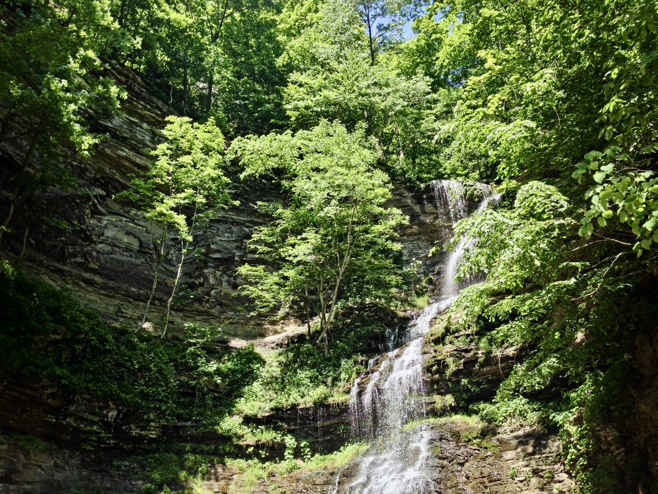
Cathedral Falls, on Cane Branch just off US-60 near Gauley Bridge, is the easy win of the group. It tumbles around 60 feet down a tiered rock face inside a small state-owned roadside park, and you can walk up to its base in a couple of minutes from the parking area — no real hiking required. Because Cane Branch is a modest stream, Cathedral is at its most dramatic in spring or after heavy rain; in late summer it can thin to a trickle. Its accessibility and photogenic amphitheater of rock make it one of the most-photographed falls in the state.
Blackwater Falls, in Blackwater Falls State Park near Davis, may be the most iconic of all. The Blackwater River plunges about 57 feet over a sandstone ledge, its water stained the color of strong tea by tannins leached from spruce and hemlock needles upstream — the source of both the river's and the park's name. A wooden stairway of roughly 200-plus steps (the marked trail is about half a mile round trip and rated easy, though the climb back up is a workout) leads to viewing platforms. Like the others, it peaks with spring snowmelt from April to June, and the Davis area's high elevation means it also draws crowds for winter and autumn color.
The Davis & Thomas Cluster: Elakala and Douglas Falls
The high country around Davis and Thomas is the densest concentration of accessible falls in the state, and two more are worth pairing with Blackwater on the same trip. Elakala Falls sits inside Blackwater Falls State Park, where Shays Run drops roughly 35 feet in a plunge beneath a footbridge near the Blackwater Falls Lodge. The walk in is short — about half a mile round trip on an easy trail — and the falls are a favorite of photographers for the way the stream pours directly under the bridge and into a rhododendron-choked glen. Be aware that the rocks below the first drop are slick and the unofficial paths to the lower tiers are steep and unmaintained; the upper falls is the safe, photogenic stop.
A few miles north near Thomas, Douglas Falls is a different animal. Here the North Fork of the Blackwater River spills about 35 feet over a broad block ledge in the Monongahela National Forest, reached by a short trail of around 0.6 miles. The setting carries the marks of the region's coal-and-coke history — the water and rocks downstream are tinted orange in places by acid mine drainage, a sobering bit of industrial legacy layered onto an otherwise wild scene. The falls themselves are wide and powerful in spring, and the easy access makes Douglas a popular spot with both swimmers and photographers in warmer months.
Basing yourself in Davis or Thomas lets you string Blackwater, Elakala, and Douglas together in a single day, since none requires a serious hike. All three run best in spring, when snowmelt off the surrounding 3,000-foot-plus plateau keeps the rivers loud and full.
New River Country: Sandstone and Brush Creek Falls
Down in the southern part of the state, the falls take on the broad, ledgy character of the New River drainage. Sandstone Falls is the largest waterfall on the entire New River, located within New River Gorge National Park & Preserve near Hinton. Rather than a single tall plunge, it's a wide, stepped block falls — the river spreads across the full channel and drops about 25 feet over sandstone ledges, broken up by islands. A boardwalk loop of roughly half a mile, rated easy and partly accessible, carries you out over side channels to viewing points. It's at its most thunderous during spring snowmelt and after heavy rain, when the New runs high.
Not far away near Athens, Brush Creek Falls offers a more intimate woodland counterpart. Brush Creek drops about 25 feet over a block ledge within a Nature Conservancy preserve, reached by a short trail of around half a mile rated easy. Because it sits on a conservancy-managed preserve rather than a busy state or national park, it tends to be quieter, and the surrounding forest and creek pools make it a pleasant short outing. As with most southern West Virginia falls, spring is the best season; the creek can run low by late summer.
These two pair naturally with a visit to the New River Gorge region, which is better known for its 876-foot New River Gorge Bridge and its whitewater than for waterfalls — but Sandstone and Brush Creek prove there's quiet water worth seeking out away from the rapids.
Backcountry and State-Forest Falls: Cheat, Holly River, Kumbrabow, and Camp Creek
For hikers willing to work for it, the High Falls of Cheat is the prize. Located on Shavers Fork of the Cheat River deep in the Monongahela National Forest near Glady, this roughly 20-foot block falls spans the full width of a substantial river, making it broad and powerful rather than tall. Reaching it on foot is a commitment — the documented trail runs about 7.6 miles round trip and is rated moderate. Many visitors instead reach it via a seasonal scenic railroad excursion that stops near the falls, which is the easiest way for non-backpackers to see it. Spring is the prime season, when Shavers Fork is at full volume.
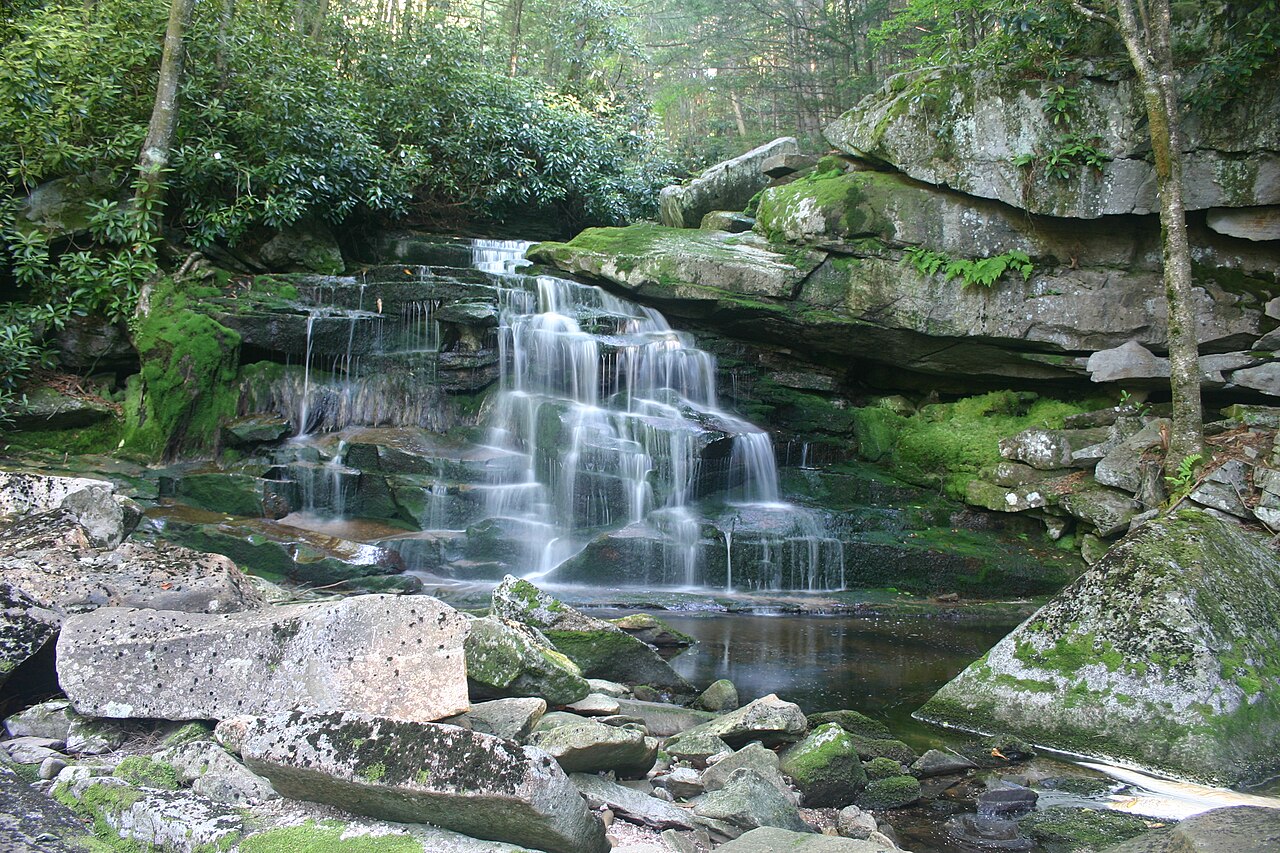
Holly River State Park near Hacker Valley holds a small constellation of falls along the Left Fork of the Holly River and its tributaries. The Upper Falls of Holly River is a 20-foot cascade reached by a short, easy trail, while Tenskwatawa Falls — a roughly 12-foot block falls on a side branch named for the Shawnee prophet — sits at the end of a moderate hike through the park's forest. Both are best in spring, and together they make Holly River a rewarding destination for a day of low-mileage falls-hunting in a quiet, less-trafficked park.
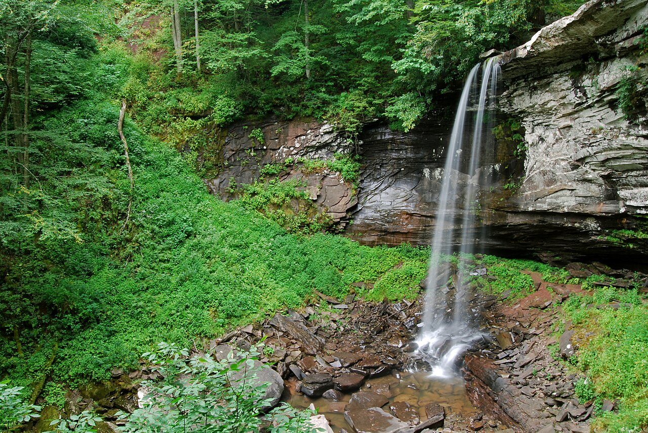
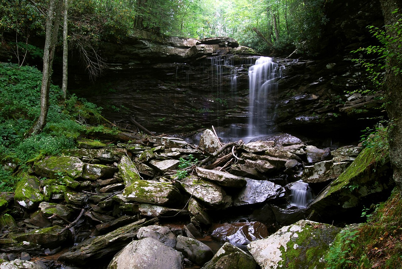
Two more reward the explorer. Mill Creek Falls in Kumbrabow State Forest, near Huttonsville, is a roughly 20-foot cascade managed by the West Virginia Division of Forestry, reached by a short but moderate trail in one of the state's highest and most remote forests. Mash Fork Falls in Camp Creek State Park, near the community of Camp Creek, is the opposite kind of experience entirely — a 12-foot cascade right beside the park road, an easy roadside stop that's especially pretty in spring runoff.
Rounding out the list, Valley Falls State Park near Fairmont protects a series of ledge falls where the Tygart Valley River drops about 10 feet over wide sandstone shelves. A short trail of roughly 0.2 miles, rated easy, reaches the main viewing area along the river, where the falls and the old mill-town history make for a relaxed afternoon. As with nearly every falls in this guide, the Tygart is at its loudest in spring.
Planning Your Visit: Seasons, Safety, and a Curated Note
Timing matters more than almost anything else with West Virginia waterfalls. The overwhelming majority run best during spring snowmelt — roughly April through June — when runoff from the high plateau keeps creeks and rivers full. Falls on small streams, like Cathedral Falls and Mash Fork, can shrink dramatically by late summer, while big-river falls like Sandstone and High Falls of Cheat hold water better but are most dramatic after spring melt and heavy rain. Autumn pairs lower flow with spectacular foliage, particularly around Davis and Thomas; winter can ice the falls into something otherworldly but makes trails and stairways genuinely hazardous.
Safety deserves a flat statement: the rock around Appalachian waterfalls is slick, the moss is slicker, and every year people are injured climbing on wet ledges or scrambling to off-trail lower tiers. Elakala Falls and the lower reaches of Falls of Hills Creek are common spots for trouble. Stay on maintained trails and viewing platforms, respect closures, and don't wade above a falls. Check land-manager websites before you go — state parks, the national forest, and New River Gorge National Park each post their own trail conditions, hours, and seasonal access notes.
Finally, be clear-eyed about what this list is. West Virginia has hundreds of named and unnamed waterfalls scattered across its public and private land, and a great many more that appear only at high water. This is a curated selection of well-documented, mostly publicly accessible falls chosen to represent the range of the state — roadside to backcountry, north to south, modest ledge to multi-tiered plunge. It is not a complete catalog, and some of the finest small falls in the state never make any list at all. Treat it as a starting point for your own exploration.