How to use this guide (and what it leaves out)
Pennsylvania has hundreds of documented waterfalls, concentrated in the glaciated northeast, the Pocono Plateau, and the deeply cut gorges of the Laurel Highlands in the southwest. No single article can responsibly catalog all of them, and this one does not try. What follows is a curated selection of nine falls that are well documented in public records, reliably reachable by ordinary visitors, and representative of the different kinds of waterfall the state produces — towering tiered drops, walk-behind curtains, and roadside cascades you can see in five minutes.
A word on the numbers you will see here. Reported waterfall heights vary widely depending on who measured them and how. A figure can describe a single vertical plunge, the tallest visible step, or the full cumulative drop of a long cascade, and state-park brochures, the USGS Geographic Names Information System (GNIS), and independent surveys like the World Waterfall Database often disagree by ten or twenty feet on the same feature. Ganoga Falls, for instance, is commonly listed at 94 feet but is measured by some sources at 89 feet over two steps. Treat every height in this guide as a documented estimate, not a surveyed certainty, and do not expect the falls to look exactly as tall as the number suggests.
Trail distances and difficulty ratings below come from land managers and trail records where available. Conditions change — gorge trails wash out, sections close after storms, and seasonal flow swings enormously — so always check the managing agency's current status page before you go. That caution is not boilerplate here: one of the most famous falls on this list, Glen Onoko, is currently closed entirely, and ignoring that closure has cost lives.
The flagship: Ricketts Glen's Falls Trail
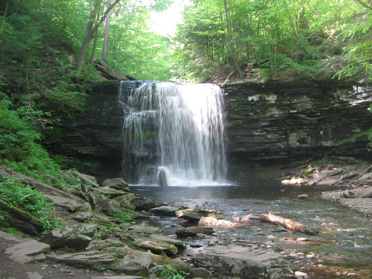
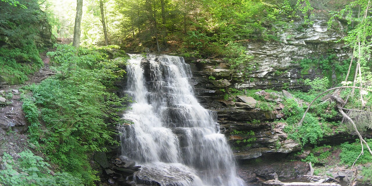
If you visit only one waterfall destination in Pennsylvania, it should be Ricketts Glen State Park near Benton in the north-central part of the state. The park's Glens Natural Area — a National Natural Landmark since 1969 — packs 21 to 22 named waterfalls into the Kitchen Creek drainage, where two branches of the creek tumble off the Allegheny Front and meet at a confluence called Waters Meet. Sources count the falls slightly differently: the DCNR names 22, GNIS names 23, and Scott Brown's standard field guide counts 24. The signature loop is widely regarded as one of the best waterfall hikes in the eastern United States.
The crown jewel is Ganoga Falls, the tallest in the park at a documented 94 feet (some surveys say 89 feet over two steps), descending the Ganoga Glen branch of Kitchen Creek as a broad veiling cascade. Reaching it is a strenuous undertaking: the popular 3.2-mile loop combines the Highland Trail with the Ganoga Glen and Glen Leigh descents, while hiking both glens in full runs roughly 7.2 miles with close to 1,000 feet of elevation change on rocky, slippery, steeply graded footing. Sturdy shoes and dry-ish conditions matter — this is not a sneaker stroll, and the same stone that makes the gorge beautiful makes it treacherous when wet or icy.
Along the way you pass a string of named falls worth knowing. Harrison Wright Falls, a 27-foot block-form curtain on Kitchen Creek, is among the most photographed in the park. Erie Falls, on the Glen Leigh side, is a scenic cascade with a single drop reported at more than 45 feet (the data here lists 47), reached on the longer roughly 6.3-mile circuit. And you do not have to hike the gorge at all to see a waterfall: Adams Falls sits just off Route 118 near the Lake Rose trailhead area, a 36-foot multi-tier cascade (the tiers are not all visible at once) reachable on a short 0.4-mile path — the easiest, most accessible falls in the park and a fine option for anyone who cannot manage the descent.
Spring snowmelt from roughly April through June delivers the heaviest, most dramatic flow, and autumn pairs lower water with spectacular foliage framing the drops. Summer can run thin in dry spells. Winter transforms the glen into ice climbing terrain but closes the Falls Trail to casual hiking — it is genuinely dangerous on ice and is managed accordingly.
The Poconos: Bushkill and the Delaware Water Gap
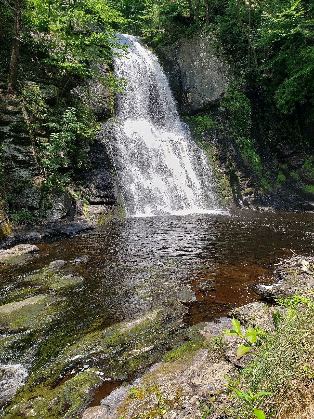
The eastern Poconos offer two very different waterfall experiences. Bushkill Falls, near the village of Bushkill in Lehman Township, is the state's best-known commercial attraction — a privately owned property that has welcomed visitors since 1904 and earned the marketing nickname 'the Niagara of Pennsylvania.' The headline feature is the Main Falls on Little Bushkill Creek, a tiered drop of about 100 feet, one of eight cascades on the 300-acre property. A network of maintained trails, bridges, and stairways threads the gorge; the shortest loop to the Main Falls runs roughly 0.75 mile on easy, well-built infrastructure, while the full Red Trail covers nearly two miles and all eight falls.
Because Bushkill is private, it charges admission and keeps seasonal hours, which is a meaningful trade: you get railings, restrooms, and a guaranteed-maintained path in exchange for a ticket. The boardwalks make it one of the most family-friendly waterfall outings in the state. Flow is best during spring snowmelt from April through June; the falls run year-round but thin out in late-summer dry spells.
A short drive north, the Delaware Water Gap National Recreation Area protects the wilder, free-and-public Hornbecks Creek, historically called Indian Ladders for the way the stream steps down stair-like shale ledges between two larger drops. Managed by the National Park Service near Dingmans Ferry, the creek holds several falls and numerous cascades. Note an important quirk of the current trail: severe storm damage closed the steep middle section of the gorge, so the route now exists as two separate out-and-back segments — Lower and Upper Hornbecks Creek — rather than one continuous path. The combined out-and-back to the documented falls is on the order of 2.7 miles at a moderate difficulty. Spring is the season to catch these falls at full strength; by midsummer the smaller drops can shrink to a trickle. Always check NPS trail status before driving out, since gorge closures here are common.
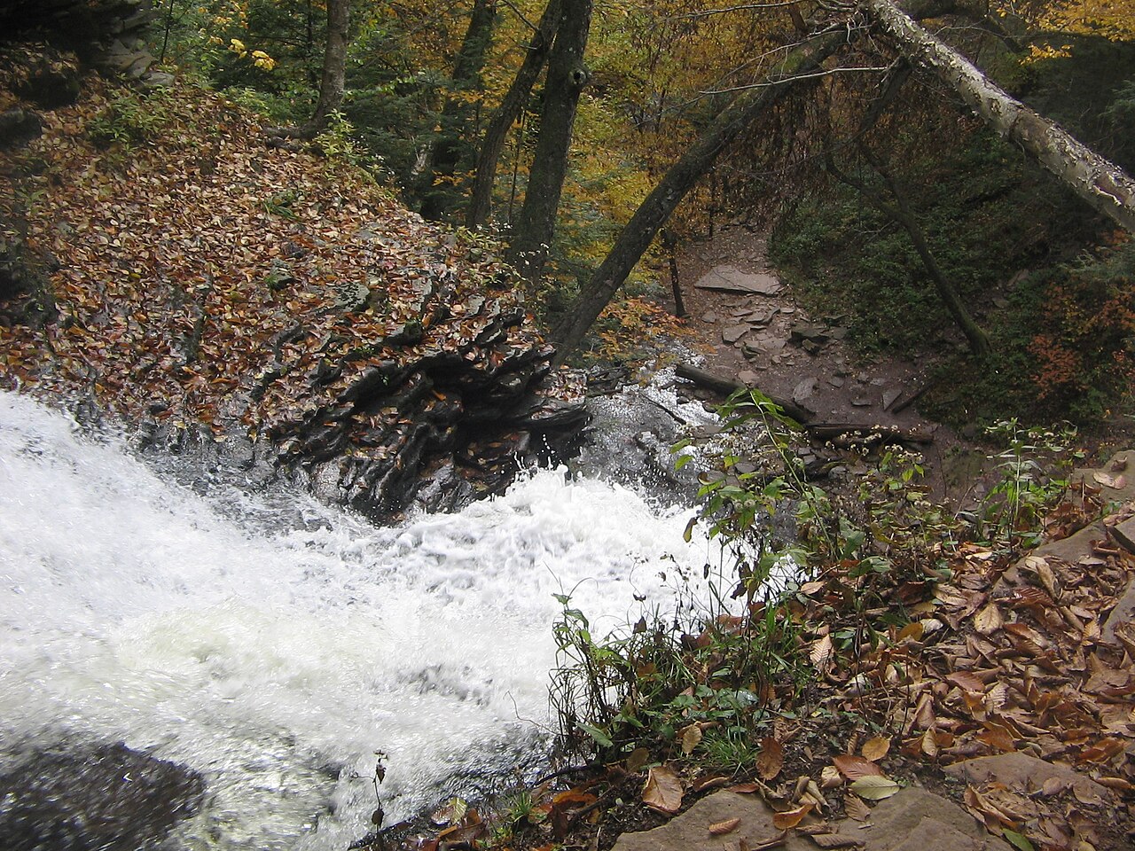
The cautionary tale: Glen Onoko is closed — do not hike it
Glen Onoko Falls, near Jim Thorpe in Carbon County, was for decades one of the most popular and most photographed hikes in eastern Pennsylvania — a roughly 3.1-mile strenuous scramble up Glen Onoko Run past a series of cascades, the largest dropping about 60 feet. It is included here precisely because its fame outlived its access, and online trip reports still draw people to a trailhead that is officially closed.
The Pennsylvania Game Commission, which managed the tract as part of State Game Lands 141, closed the falls trail on May 1, 2019, citing deteriorating conditions and a grim safety record. Reporting at the time tallied roughly 14 medical emergencies involving 18 visitors since 2008, including seven deaths; over the last half-century at least ten people have died in the glen. The combination of unstable footing, exposed dropoffs, and slick rock near the cascades makes the off-trail areas genuinely lethal, and rescues are complex and costly.
There is movement toward reopening. The state has advanced a plan to transfer the Glen Onoko tract from the Game Commission to the Department of Conservation and Natural Resources and fold it into Lehigh Gorge State Park, paired with a substantial trail-rehabilitation project. As of mid-2026, however, the Falls Trail and its connector remain closed while construction continues, and officials have indicated the closure holds through the year. Until DCNR formally reopens it, treat Glen Onoko as off-limits — the photos are not worth your life, and the closure is enforced.
The Laurel Highlands and a quiet northeastern gem
Pennsylvania's southwest corner holds its most concentrated waterfall scenery outside Ricketts Glen, centered on Ohiopyle State Park where the Youghiogheny River carves a deep gorge. The star here is Cucumber Falls, a roughly 30-foot punchbowl-style curtain where Cucumber Run pours over a sandstone overhang into a clear, shallow pool. It is one of the easiest worthwhile falls in the state to reach: a short 0.3-mile path from a roadside lot off Ohiopyle Road drops to the crest, the base, and — during lower flow — behind the cascading water itself. The gorge walls trap the sound in a way that makes the drop feel taller than it is.
Cucumber Falls runs best at spring peak flow and stays attractive through fall, but its compact parking area is its limiting factor: on summer weekends between Memorial Day and Labor Day the small lot fills early in the morning. Arrive at opening or plan a weekday visit. The falls also connect via the Great Gorge and Cucumber Run trails to a wider network of Ohiopyle hikes, so it works as both a five-minute stop and the anchor of a longer outing.
Back in the northeast, Choke Creek Falls offers a different kind of reward: solitude. Tucked in the Thornhurst Tract of Pinchot State Forest near Thornhurst, this roughly 20-foot cascade on Choke Creek is reached by a gentle 1.4-mile (the data lists this distance; the shortest out-and-back is often cited near 0.75 mile) easy walk, mostly along old access roads now incorporated into the rerouted Pinchot Trail. The drive in covers several miles of well-maintained dirt forest roads. It is a popular summer swimming and rope-swing spot for locals, and its spring-and-summer flow and easy grade make it an excellent low-effort family destination — bring a leash if you bring the dog.
Picking the right falls for your trip
If you want maximum waterfall per mile and you are fit, Ricketts Glen is unrivaled — plan a full day, wear real hiking shoes, and time it for spring melt or autumn color. If you want a guaranteed, well-maintained, kid-friendly experience and do not mind paying admission, Bushkill Falls delivers the tallest single showpiece on this list with railings and restrooms. For the easiest genuinely impressive falls, Cucumber Falls at Ohiopyle and Adams Falls at Ricketts Glen are both short, low-effort walks to substantial drops.
Season is the single biggest variable in whether a trip succeeds. Across the state, spring snowmelt from roughly April through June produces the heaviest flow, and that is when even the smaller falls look their best. Autumn trades volume for foliage and thinner crowds. Late summer can disappoint at lower-volume falls like Hornbecks Creek and Choke Creek after dry stretches, while winter brings ice that closes gorge trails such as Ricketts Glen's Falls Trail to ordinary hikers. Match your destination to the calendar rather than forcing a falls into the wrong season.
Finally, respect closures and conditions. Glen Onoko remains closed and dangerous; gorge trails in the Delaware Water Gap and at Ricketts Glen wash out or ice over; and even easy paths get slick near the water. Check the managing agency — DCNR for state parks and forests, the NPS for the Delaware Water Gap, and the private operator for Bushkill — for current status before you drive. The falls have been here for thousands of years and will keep running; there is no reason to take a risk to catch one on a bad day.