How to Think About Waterfalls in a Desert State
Arizona surprises people. It is the second-driest state in the country, yet it holds waterfalls that rival anything in better-watered parts of the U.S. — from the turquoise plunge pools of Havasu Creek deep in the Grand Canyon to a 185-foot torrent of chocolate-colored snowmelt on the Little Colorado River. The catch is that most Arizona waterfalls are seasonal and depend entirely on two things: spring snowmelt off the high country (the Mogollon Rim, the White Mountains, the San Francisco Peaks) and the summer monsoon, which typically runs July through September. Show up at the wrong time and many of these falls are a trickle or bone dry.
This guide is a curated selection, not a complete inventory. Arizona has dozens of documented falls and countless unnamed seasonal cascades that appear after a storm and vanish a day later. We have focused on the falls that are real, documented, and worth planning a trip around — the ones with names, established trailheads, and a track record in public records and guidebooks. We have ordered them loosely by height and stature, starting with the giants, but height alone is a poor ranking: a reliable, accessible 25-foot cascade you can actually reach beats a 200-footer that runs three weeks a year.
A word on the numbers. Reported waterfall heights in Arizona vary a lot by source and by what is being measured — a single clean plunge versus the cumulative drop of a multi-tiered cascade. The figures here come from our dataset and cited guidebooks, and where a fall is a tiered cascade rather than one sheer drop, treat the height as approximate. We have flagged the cases where this matters most.
Most important: a large share of Arizona's best waterfalls sit on tribal land, and access rules change. Several require paid permits booked in advance, and at least one major fall — Grand Falls — has been closed to non-tribal visitors since 2023. Always confirm current access with the land manager before you go. Nothing in this guide overrides a closure posted by a tribe or land agency.
The Havasu Creek Falls: Arizona's Crown Jewels (Permit Required)
No discussion of Arizona waterfalls starts anywhere but Havasu Creek, the spring-fed tributary deep in the western Grand Canyon on the Havasupai Reservation. The water here is a saturated blue-green from dissolved travertine, and it tumbles over a series of falls below the village of Supai. These are genuine bucket-list destinations — and they are strictly permit-only, with no day hiking allowed. Permits are released annually (early-access permits in late January, standard permits on February 1) and routinely sell out in minutes for the entire season. Reservations are sold as a 3-night, 4-day package, and the trip is a serious backcountry undertaking.
Havasu Falls is the iconic one: a roughly 100-foot plunge into a wide, photogenic turquoise pool, reached after about a 20-mile round-trip hike from the Hualapai Hilltop trailhead through Supai village to the campground. It is rated strenuous, and the eight-mile descent to the village is the easy part — the climb out in desert heat is what breaks people. Spring and fall (roughly March–May and September–October) are the best windows, avoiding both winter cold and dangerous summer flash-flood risk.
Mooney Falls is the tallest of the group at about 200 feet — the highest waterfall on Havasu Creek and one of the tallest in the state. It sits just below the campground, but reaching its base is the most exposed scramble on the whole trip: a near-vertical descent through two short travertine tunnels using fixed chains, ladders, and metal stakes, often slick with spray. It is not for anyone uneasy with heights. Counting the approach, plan on a round trip of roughly 20 miles or more. Continue another 3-plus miles downstream and you reach Beaver Falls, a lower (around 40-foot) set of tiered cascades and pools — the turnaround point for most campers, at roughly a 6-mile round trip from the campground, and a worthwhile half-day in its own right.
Because the entire Havasu Creek system is gated behind one of the hardest-to-get permits in American backpacking, treat these three as a single trip rather than separate outings. If you land a permit, you can see all of them; if you do not, you cannot legally see any of them. Do not attempt to reach Havasu Falls as a day hike — it is prohibited, and people have died trying.

Grand Falls and the Grand Canyon's Other Plunge
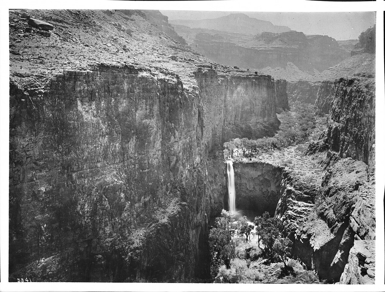
Grand Falls — better known as Chocolate Falls — is one of Arizona's most spectacular and most misunderstood waterfalls. At about 185 feet, this tiered drop on the Little Colorado River, roughly 30 miles northeast of Flagstaff on the Navajo Nation, is actually taller than Niagara. Its nickname comes from the water itself: heavy with suspended sediment, it runs the color of churning chocolate milk. The flow is famously fickle, driven by snowmelt off the White Mountains in March and April and by monsoon storms — locals say it truly runs only a handful of times a year, and it is bone dry the rest of the time.
Here is the part you must not skip: as of March 2023, the Leupp Chapter of the Navajo Nation closed Grand Falls to non-tribal visitors, citing trash, off-road damage, and disrespect of cultural sites, and as of mid-2024 reporting the closure was still being maintained by the local community. We are featuring Grand Falls because it is a defining Arizona waterfall and you will see it on every list — but do not plan a trip there expecting access. Confirm the current status directly with the Navajo Nation before considering any visit, and honor a posted closure.
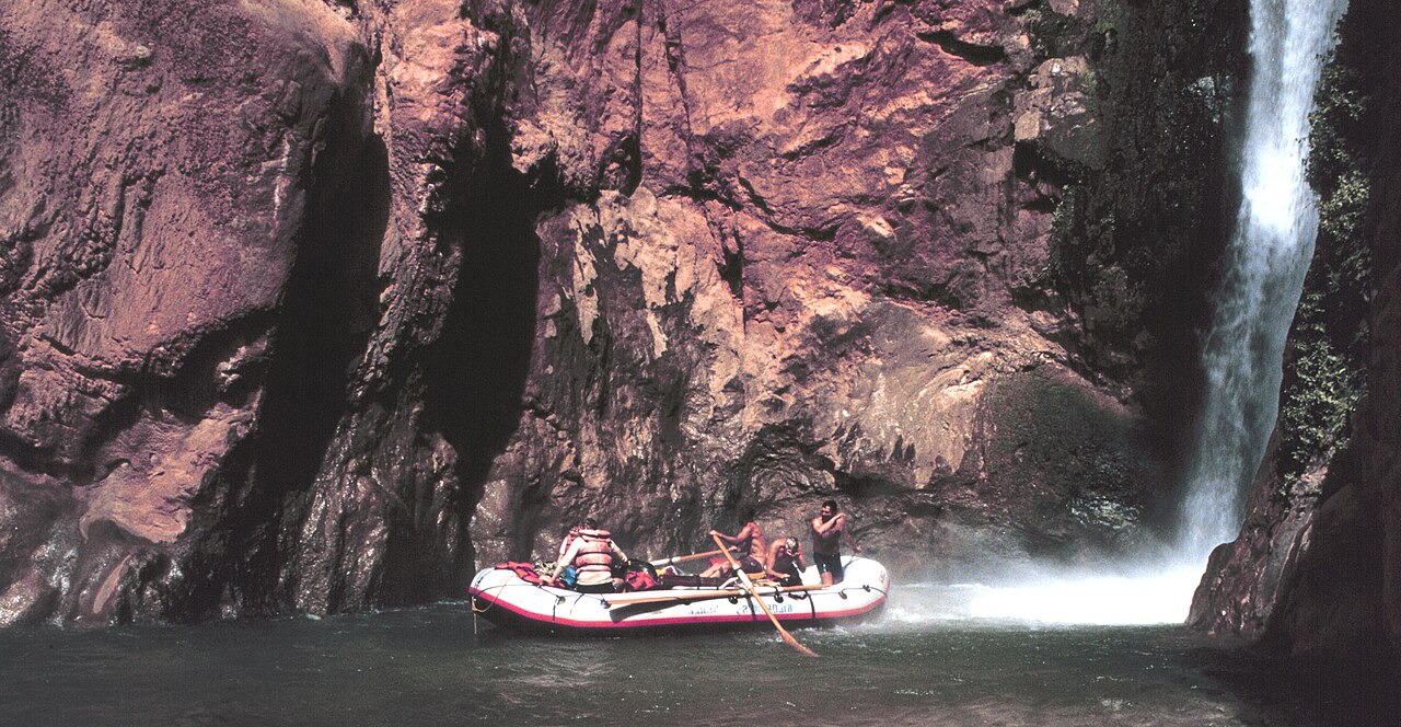
Far across the state, Deer Creek Falls offers a different kind of Grand Canyon waterfall. This roughly 100-foot plunge drops near the confluence of Deer Creek and the Colorado River, on land managed by Grand Canyon National Park. For most people it is seen from a river trip, but it is also reachable on foot as a committing backcountry hike — on the order of a 19- to 20-mile round trip from the North Rim side near Fredonia, rated strenuous and best attempted in spring or fall to avoid lethal summer canyon heat. Above the main falls, a narrow ledge route leads up to the 'patio,' a popular vantage and rest spot for those comfortable with exposure.
Both of these falls underscore the theme of Arizona's biggest waterfalls: the spectacle is real, but access is the hard part — gated by tribal sovereignty in one case and by sheer backcountry distance in the other.
The Rim Country and White Mountains: Snowmelt and Monsoon Falls
Central Arizona's high country — the Mogollon Rim and the forests around Payson, Young, and the White Mountains — is where you find the state's most rewarding mix of accessibility and drama. Workman Creek Falls is the standout for low effort and high payoff: an roughly 200-foot horsetail fall in the Sierra Ancha of the Tonto National Forest, near the tiny town of Young. The overlook is essentially roadside — a short walk of about 0.2 miles, rated easy — though the unpaved Forest Road to reach it is rough, impassable when wet, and rewards a high-clearance vehicle. It runs best with spring snowmelt and again after summer monsoon rains.
Nearby, Water Wheel Falls on Ellison Creek sits about 9 miles north of Payson at the base of the Mogollon Rim in the Tonto National Forest. It is a modest but pretty cascade reached by a roughly 1.6-mile trail rated moderate, and it is a popular summer swimming spot. It also carries a real warning: this drainage is prone to sudden, deadly flash floods that can arrive faster than you can hear them, so check the upstream weather and never linger in the narrows when storms threaten — a lesson the region learned tragically. Best flow comes during spring snowmelt and the summer monsoon.
The White Mountain Apache (Fort Apache) Reservation holds two excellent — and permit-required — falls. Pacheta Falls is a remote, roughly 130-foot plunge on Pacheta Creek near Whiteriver, reached by a moderate hike of about 2.5 miles, with late spring through early summer the prime window as the high country sheds its snow. Cibecue Falls is a roughly 30-foot plunge on Cibecue Creek with a vivid pool, reached by a wet, scrambly canyon route of about 4 miles round trip near the town of Cibecue. Both require an access permit from the tribe (Cibecue's runs about $45 per person per day), and swimming is prohibited in tribal waters — rules worth taking seriously.
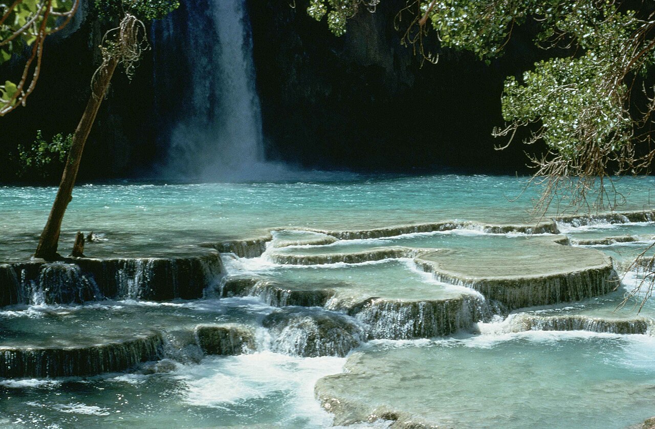
Fossil Creek Falls rounds out the Rim country. Fossil Creek is a federally designated Wild and Scenic River fed by travertine-rich springs, producing famously blue-green water, and it sits on the Coconino National Forest near Camp Verde. The waterfall is reached by a roughly 2.2-mile trail rated moderate, and it runs essentially year-round thanks to the spring source. Note the access logic: from roughly April 1 to October 1, a reserved entry and parking permit is required, while outside that window no reservation is needed — a system designed to manage heavy summer crowds at one of central Arizona's most popular swimming holes.
The Tucson Falls: Sky Island Cascades After the Rain
Southern Arizona's 'sky island' ranges — the Santa Catalina and Rincon Mountains around Tucson — hold a cluster of cascades that come alive after winter storms and snowmelt. These are not towering plunges; they are canyon cascades and plunge pools, and their appeal is the contrast of running water against Sonoran Desert. Timing is everything: visit after rain or snowmelt in winter and spring, and you will find flowing water and pools; visit in the dry early summer and you may find dry rock.
Tanque Verde Falls, in the Coronado National Forest's Redington Pass area east of Tucson, is the best-known. The roughly 80-foot cascade caps a hike of about 1.8 miles rated moderate, with the difficulty coming from steep, slick rock rather than distance. It is gorgeous after a good rain — and genuinely hazardous, with a history of drownings and flash-flood fatalities when storms hit upstream, so respect the conditions and stay out of the channel when rain is in the forecast.
Seven Falls, reached through Bear Canyon out of the Sabino Canyon Recreation Area, is the classic Tucson waterfall hike: a string of cascades and pools strung up the canyon, reached on a roughly 8.5-mile round-trip route rated moderate (shorter if you ride the shuttle to the Bear Canyon trailhead). It is at its best in spring, when snowmelt keeps the multiple tiers flowing. Because the canyon's height is genuinely variable depending on flow, treat it as a tiered feature rather than a single measured drop.
Romero Pools, in Catalina State Park climbing into the Pusch Ridge Wilderness of the Coronado National Forest near Oro Valley, is more about the pools than a single fall — a series of cascades and clear basins reached by a roughly 5.6-mile round-trip hike rated moderate, best in late winter and spring after rain or snowmelt. Together these three make Tucson a legitimate, if seasonal, waterfall destination — just plan your visit around the weather, not the calendar.
Planning Your Trip: Permits, Seasons, and Safety
Three rules will save your Arizona waterfall trip. First, chase the water, not the date. With the exception of spring-fed Fossil Creek and Havasu Creek, nearly every fall here is snowmelt- or monsoon-driven. Spring (after a good snow year) and the days following summer monsoon storms are the high-flow windows; mid-summer before the monsoon and late fall are often dry. Check recent trip reports and streamflow before committing to a long drive.
Second, sort out access before you leave. Havasu, Mooney, and Beaver Falls require a hard-to-get Havasupai permit with no day-use option. Pacheta and Cibecue Falls require White Mountain Apache permits, with swimming prohibited in tribal waters. Fossil Creek requires a reserved permit from roughly April through September. And Grand Falls has been closed to non-tribal visitors since 2023 — do not assume you can go. When a fall is on tribal land, the tribe's rules are the law, and they exist for good reasons.
Third, take flash floods seriously. Several of these canyons — Tanque Verde, Water Wheel, the Havasu corridor — have killed visitors caught by sudden surges from storms miles upstream, water that can arrive before you hear it. Never enter a slot or narrow canyon when rain is in the forecast anywhere in the watershed, and get to high ground at the first sign of rising or muddying water. Carry far more water than you think you need; the strenuous Grand Canyon and reservation hikes are unforgiving in heat, and the climb out is always the hard part.
Finally, treat this as a starting list. Arizona has more documented falls than any single guide can cover, and conditions, permit systems, and closures change every year. Use the names, distances, and seasons here to plan, then verify the current details with the National Park Service, the relevant National Forest, the state park, or the tribe before you go.