How to read this guide (and why it's a curated list)
Alaska is impossible to inventory completely when it comes to waterfalls. The state is roughly a fifth the size of the rest of the country combined, much of it roadless, glaciated, and unnamed on any map. Meltwater pours off hanging glaciers and snowfields by the thousands every summer, and only a small fraction of those drops have an official name in the U.S. Geological Survey's Geographic Names Information System (GNIS), let alone a maintained trail. So treat this as a curated field guide to documented, reachable falls — the ones with names, access, and a public-record paper trail — rather than a ranking of every waterfall in Alaska.
We've ordered the list to be useful rather than strictly by height. The two giants of Keystone Canyon come first because they're the most spectacular roadside falls in the state and the easiest to see. After that we move roughly from the marquee glacier-fed cataracts down to the short, family-friendly walks, grouping by region where it helps — Southcentral around Anchorage and the Kenai Peninsula, and Southeast around Juneau and Skagway — so you can plan a realistic day.
One honest caveat on numbers: reported waterfall heights in Alaska vary a lot by source and by what's being measured. A figure like "377 feet" for Nugget Falls is a cumulative drop across two tiers, not a single sheer plunge, and other published heights are best estimates rather than surveyed measurements. Where we give a height, treat it as an approximate documented figure, and expect different guidebooks to disagree by tens of feet. The data points here — heights, trail distances, land managers, and seasons — come from agency sources (NPS, U.S. Forest Service, Alaska State Parks), trail databases, and waterfall references, all listed at the end.
Finally, a safety note that applies to nearly every entry below: many of these falls sit in active bear country, several share trails with spawning-salmon streams, and Alaska's spring meltwater can make creeks dangerously high and cold. Stay behind railings at viewpoints, give wildlife room, and check current trail conditions with the managing agency before you go.
The Keystone Canyon giants: Bridal Veil and Horsetail Falls (Valdez)
If you only see two Alaska waterfalls, make them the pair in Keystone Canyon, a roughly three-mile gorge the Lowe River carved about 12 miles outside Valdez along the Richardson Highway. The canyon walls rise more than 600 feet, and the two signature falls pour straight off them within sight of the road — no hike required, which is rare for falls of this scale anywhere.
Bridal Veil Falls is the headliner: a tiered ribbon of snowmelt commonly cited at around 600 feet, which makes it the tallest roadside waterfall in Alaska. It's reached from a pullout near Mile 13.9 on the highway, on a tributary of the Lowe River, and at peak runoff it's a genuinely thunderous wall of water. A short distance away, Horsetail Falls lives up to its name — a horsetail-form cascade of roughly 300 feet (sources range up to about 328 feet) that fans out across the rock face on the opposite side of the canyon.
Both falls are snowmelt-fed, so they run hardest from late spring through summer once the high country starts melting; by late summer their volume drops noticeably. The best time to catch them in full force is generally late May through July. Because they're roadside and the surrounding terrain is easy, they're accessible to nearly everyone, including travelers who can't manage a trail.
Their second act comes in winter. When the flow freezes, Bridal Veil and Horsetail become two of North America's premier ice-climbing destinations, drawing climbers from around the world to Valdez. Bridal Veil is a long, serious multi-pitch line (rated around WI5), while Horsetail is a shorter, more moderate climb (around WI3). You don't have to climb to appreciate them frozen — the canyon in deep winter is a spectacle in its own right, but mind the highway, ice, and avalanche conditions.
Glacier and creek cataracts of Southcentral Alaska
Closer to Anchorage, the Chugach Mountains and the Kenai Peninsula hold a cluster of falls that range from glacier-meltwater giants to easy creekside walks. The standout is Thunderbird Falls in Chugach State Park, about 30 miles northeast of Anchorage near Eklutna. A well-built trail — roughly 1.8 miles round trip with boardwalks, handrails, and viewpoints — leads to a balcony overlook of a multi-stepped cascade that drops into the Eklutna River canyon. It's rated easy, families do it regularly, and in winter the falls freeze into striking columns of blue ice that attract ice climbers.
South of town along the Seward Highway on Turnagain Arm, McHugh Creek Falls is a small but charming roadside stop in Chugach State Park. The creek thunders through a slot into a pool right beside the parking and picnic area, with a viewing platform a short walk away. It's only about 20 feet, but the coastal-meets-mountain setting and the no-effort access make it a worthwhile pull-off, and it doubles as a trailhead into the wider park.
Near Girdwood, about 45 minutes south of Anchorage, the Winner Creek Trail in Chugach National Forest is a beloved easy walk — a wide, well-developed path of roughly 4.5 miles round trip that winds through coastal rainforest and crosses a wooden bridge over a thundering blue-water gorge on Winner Creek. Best hiked June through September, it has long been famous for a hand-pulled tram across Glacier Creek at its far end. Note for current planning: that hand tram is closed in 2026, with a suspension bridge planned to replace it, so confirm trail status and the end-point experience before you set out.
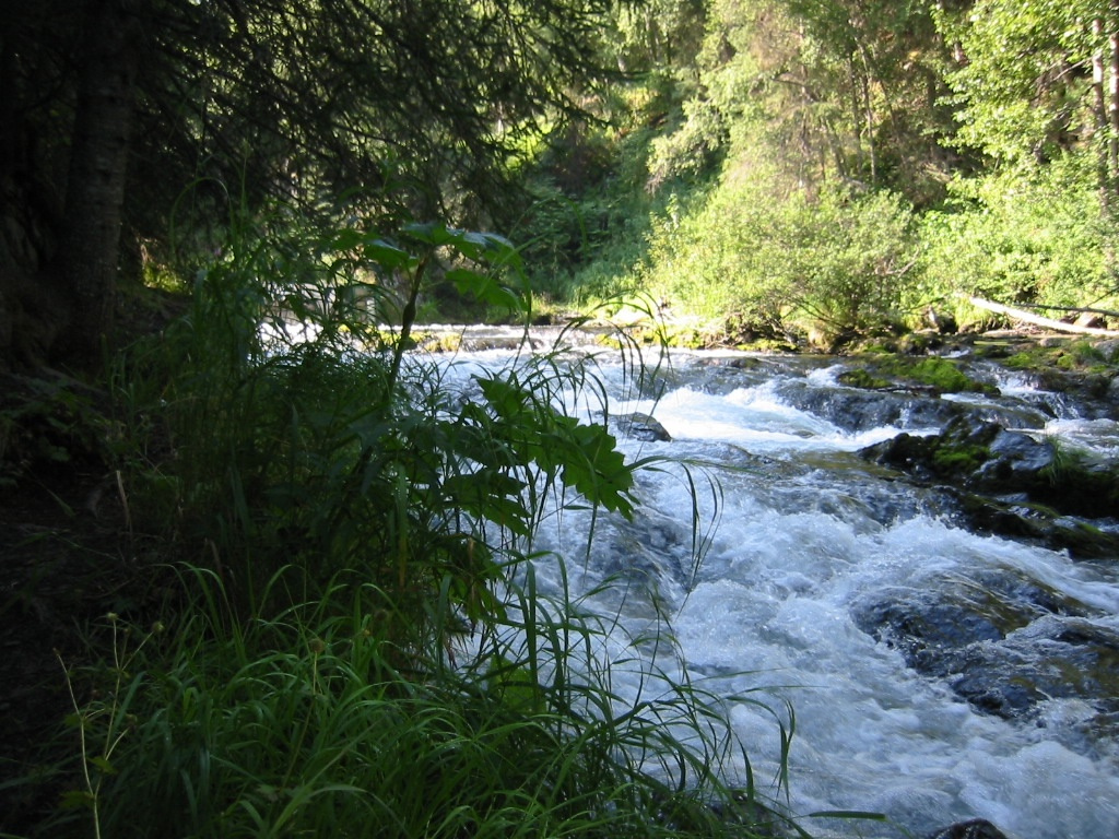
On the Kenai Peninsula near Cooper Landing, two more falls round out the region. Russian River Falls, reached by an easy gravel trail of about 4.8 miles round trip in Chugach National Forest, is less about height than about the show: from a viewing platform you can watch salmon leaping upstream, with the run typically on from mid-June through September and bears occasionally fishing the water — keep your distance and follow posted bear protocols. Deeper into the same range, Juneau Creek Falls is the premier cataract on the famous Resurrection Pass Trail, sitting about four miles in from the southern trailhead (roughly a 7.5-mile day round trip to the falls and back). It's a more committing, moderate outing through real backcountry rather than a quick stop.
Southeast Alaska: Nugget, Salmon Creek, and Lower Reid Falls
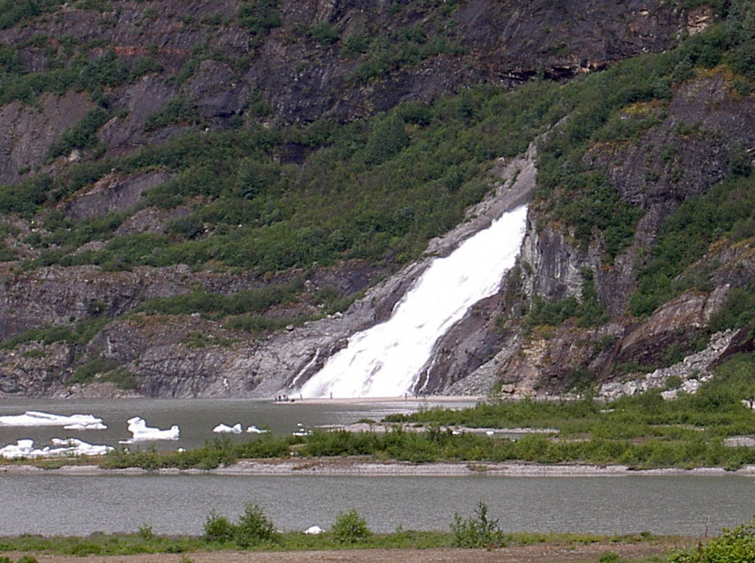
Alaska's panhandle is rainforest country, and its falls reflect it — they run reliably all summer thanks to abundant rain and glacier melt. The crown jewel is Nugget Falls outside Juneau, which tumbles off the mountainside into Mendenhall Lake just south of the active face of Mendenhall Glacier in the Tongass National Forest. Fed by meltwater from the hanging Nugget Glacier, it makes its descent in two tiers of about 99 and 278 feet for a cumulative drop near 377 feet. The payoff-to-effort ratio is exceptional: a flat, well-maintained gravel path of about one mile each way (two miles round trip) from the Mendenhall Glacier Visitor Center delivers you to the base, with the glacier itself in view much of the way. It's easy, heavily traveled, and best late spring through early fall.
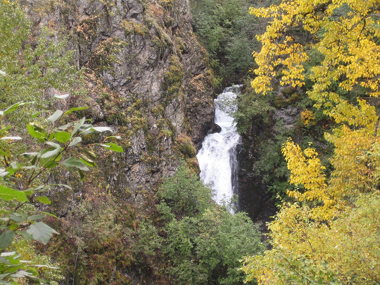
Also near Juneau, Salmon Creek Falls offers a quieter, more local experience: a roughly 100-foot plunge into a forest pool, reached on a moderate trail of about three miles that passes the historic Wagner Mine workings. In season you can watch the creek's namesake salmon spawning. It's a good summer choice for travelers who want a Juneau-area hike with a bit more solitude than the Mendenhall crowds.
Up in Skagway, Lower Reid Falls pairs a waterfall with a heavy dose of Klondike Gold Rush history. The short, easy walk from town runs through the Gold Rush Cemetery — the oldest in Skagway, established in 1898 — past the graves of figures like Frank Reid and "Soapy" Smith, then up a forest path on Reid Creek to the falls tucked in the woods. The setting sits in the vicinity of Klondike Gold Rush National Historical Park, and the combination of accessible local history plus a pretty cascade makes it a natural stop for cruise-port visitors with limited time. Summer is the season, when the creek runs full and the trail is clear.
Across Southeast, the practical advantage over Southcentral is reliability: where the snowmelt falls near Valdez and Anchorage fade by late summer, the rainforest keeps these cataracts flowing. If your trip skews toward August, weight your itinerary toward the panhandle for the surest water.
Roadside stops and short walks: Liberty Falls and the easy wins
Not every memorable Alaska waterfall demands a hike, and a few of the best are deliberately easy. Liberty Falls, on Liberty Creek near Chitina in the Copper River Valley, sits right beside the road at roughly Mile 23.5 of the Edgerton Highway within the Liberty Falls State Recreation Site. It's a modest cascade of about 20 feet, but the canyon setting, the adjacent campground, and the no-effort access make it one of the most picturesque quick stops on the route toward Wrangell–St. Elias country. There's a short trail of about a mile if you want to explore upstream, but the falls are visible essentially from the pullout.
Liberty Falls, McHugh Creek Falls, and the two Keystone Canyon giants together form a useful category for trip planning: roadside or near-roadside falls that anyone can reach regardless of fitness or time. They're the entries to anchor a driving itinerary around — the Richardson Highway through Keystone Canyon, the Seward Highway along Turnagain Arm, and the Edgerton Highway toward Chitina each string one or more of these together with minimal detour.
If you'd rather earn the view, the short-to-moderate hikes here scale up gently: Nugget Falls and Thunderbird Falls are both easy round trips under two miles, Salmon Creek and Russian River sit in the moderate, few-miles range, and Juneau Creek Falls on the Resurrection Pass Trail is the most demanding of the set. None of the falls in this guide require technical skill in summer — the difficulty is distance and terrain, not exposure.
However you build the trip, plan around season and water. Snowmelt-fed falls peak in late spring and early summer and thin out by August; rainforest falls in Southeast hold up better late in the year; and several of these falls — Bridal Veil, Horsetail, and Thunderbird among them — transform into ice in winter, becoming a completely different attraction. Match your dates to the falls you most want to see, and always confirm current conditions and closures (like the 2026 Winner Creek hand-tram closure) with the managing agency before you go.