The Headline Numbers: Where Our Waterfalls Cluster
Across the 32 states represented in this guide, the distribution is far from even. California leads decisively with 11 documented waterfalls, nearly double the next tier. Behind it sits a cluster of states tied at five or six: Oregon (6), then Hawaii, North Carolina, Colorado, Washington, and Michigan all at 5 apiece, with Wyoming close behind at 4. The remaining states each contribute a handful, and many appear just once.
These counts reflect our dataset's coverage rather than a complete census of every cataract in the country — the United States contains tens of thousands of named falls in USGS's Geographic Names Information System (GNIS) alone, and no single field guide captures them all. What the per-state numbers do reveal is which regions reliably produce the kind of large, well-documented, publicly accessible waterfalls that make it into a curated guide: tall enough to matter, fed by dependable water, and sitting on land a national park, national forest, or state park keeps open to visitors.
Read the leaderboard as a geology map and it snaps into focus. California, Oregon, Washington, Colorado, and Wyoming are mountain-and-plateau states where glaciers, volcanism, and deep river incision built abrupt vertical relief. Hawaii is a volcanic archipelago whose young, steep streams plunge off basalt cliffs. North Carolina anchors the Southern Appalachians, and Michigan — the lone flatland surprise on the list — owes its falls almost entirely to the glaciated, hard-rock Upper Peninsula. Nearly every high-count state is a place where water meets a sudden change in rock hardness or elevation.
Why California Runs Away With the Count — and the Crown
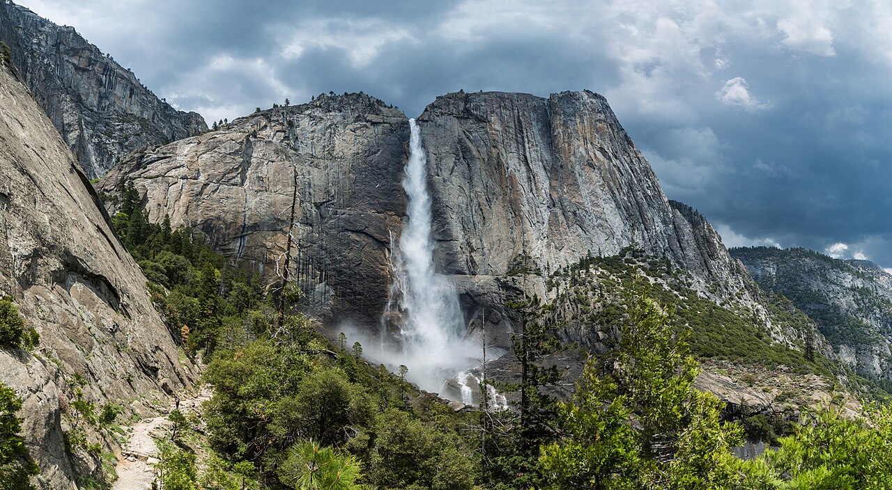
California's dominance is no accident of sampling. The Sierra Nevada is a single, immense block of granite that was uplifted along its eastern edge and then carved by Pleistocene glaciers into deep, steep-walled valleys. When those glaciers retreated, they left main valleys gouged far deeper than the side canyons that fed them — the classic 'hanging valley.' Tributary streams now reach the lip of the main valley and simply fall off the edge. Yosemite Valley is the textbook example, and it is why a single park can host multiple major falls.
It also produces the tallest waterfall in our entire dataset. Yosemite Falls, on Yosemite Creek in Yosemite National Park, drops a cumulative 2,425 feet across its upper fall, middle cascades, and lower fall combined. That figure is a tiered total rather than one continuous sheet of water, which matters: reported heights for any waterfall vary depending on whether a source measures a single vertical drop or sums an entire cascade system. Yosemite Falls is consistently ranked among the tallest in North America by those cumulative measures.
The fall is also a lesson in seasonality that applies up and down the Sierra. Yosemite Falls is fed by snowmelt, so it roars during the spring melt (roughly April through June) and can dwindle to a trickle — or stop entirely — by late summer and fall. The classic high overlook hike runs about 7.2 miles round trip and is rated a moderate to strenuous effort; visitors who only want the view can reach a lower vantage on a short, paved stroll. Plan around the calendar, not just the map: arrive in August expecting a torrent and you may find bare granite.
The Tallest in Each Corner: A Tour Down the Height Ladder
After Yosemite Falls, the tallest single waterfalls in our guide line up as a cross-section of American mountain country. Virginia's Crabtree Falls is the standout of the East at a reported 1,000 feet — a cascade, not a plunge, tumbling down Crabtree Creek in the George Washington National Forest. As a cascade its height is the cumulative drop along a series of ledges rather than one free fall, and the moderate 3.4-mile trail climbs alongside it past a sequence of overlooks. It is frequently cited as the tallest cascading waterfall east of the Mississippi.
The South contributes Amicalola Falls in Georgia at 729 feet, a tiered fall on Amicalola Creek inside its namesake state park near Dawsonville — a short hike of roughly a mile, and one of the best-known falls in the Southern Appalachians. The Pacific Northwest answers with Oregon's Multnomah Falls at 620 feet, a two-tiered drop on Multnomah Creek in the Columbia River Gorge that, unusually for a snowmelt-dominated region, flows year-round because it is fed in part by underground springs; its overlook is a 0.2-mile walk from the highway, making it one of the most accessible major falls in the country.
From there the ladder runs through the Intermountain West and beyond: Utah's Bridal Veil Falls (607 ft, a roadside tiered fall on a Provo River tributary near Provo), Montana's Bird Woman Falls (560 ft, a horsetail seen roadside from Glacier National Park's Going-to-the-Sun corridor), Hawaii's ʻAkaka Falls (442 ft, a clean plunge on Kolekole Stream reached by a short paved loop near Honomū), and North Carolina's Whitewater Falls (411 ft, a tiered fall on the Whitewater River in the Nantahala National Forest and one of the tallest in the eastern U.S.). Each represents the tallest tier of a different geologic province — and each carries the same caveat that its published height depends on how the measurement was taken.
Three Engines of Vertical Drop: Mountains, Plateaus, and Ice
Almost every waterfall in this guide owes its existence to one of three landscape-shaping processes, and the per-state pattern follows directly from which process dominates where. The first is mountain uplift paired with river incision. When a region rises and rivers cut downward through it, they expose layers of differing hardness; where a stream crosses from soft rock onto a resistant ledge, the soft rock erodes faster and a step forms. Telluride's Bridal Veil Falls in Colorado (365 ft, a plunge on Bridal Veil Creek in the rugged San Juan Mountains) is a Rocky Mountain expression of this, fed by a late-spring to early-summer snowmelt that peaks May through June.
The second engine is glaciation. Pleistocene ice sheets and alpine glaciers gouged U-shaped valleys far deeper than the tributary valleys that joined them, leaving those tributaries 'hanging' high on the wall — exactly the mechanism behind Yosemite. The Pacific Northwest's Cascade volcanoes show it too: Washington's Comet Falls (320 ft, a tiered fall on Van Trump Creek in Mount Rainier National Park) sits in glacier country, which is why its access trail only goes snow-free in summer and the fall runs hardest on summer melt, July through September. Montana's Bird Woman Falls hangs off a glacially carved cirque wall in Glacier National Park, alive on June-to-July snowmelt.
The third is volcanic and plateau terrain, where flat-lying lava flows or sedimentary beds create sharp, durable cliff edges for water to leap from. Hawaii's ʻAkaka Falls plunges off a basalt headwall, the signature of a young volcanic island whose steep streams haven't yet worn their channels smooth. Wyoming's Lower Yellowstone Falls (308 ft, a plunge where the Yellowstone River pours into the Grand Canyon of the Yellowstone) drops over a band of hard rhyolite that resists erosion while softer, hydrothermally altered rock downstream washes away — a volcanic-plateau waterfall in the truest sense, peaking on late-spring runoff in May and June.
The Outliers: Glaciated Flatlands and the Eastern Highlands
Two states on the high-count list don't fit the towering-mountain stereotype, and they're the most instructive. Michigan, tied at five waterfalls, has almost no mountains at all — its falls are concentrated in the Upper Peninsula, where ancient, hard Precambrian bedrock meets the legacy of continental glaciation. Retreating ice sheets scrambled the drainage, exposed resistant rock ledges, and left streams to find new paths over them. The lesson: you don't need altitude to make waterfalls, you need a hard rock ledge, reliable water, and a recent geologic disturbance to set up the drop. Glaciated flatlands deliver all three.
The Eastern Highlands are the other quiet powerhouse. North Carolina's five falls and Virginia's towering Crabtree Falls come from the Blue Ridge and the broader Appalachian uplift — old mountains, deeply weathered, but still steep enough where streams cross from the highlands toward the Piedmont to produce dramatic drops like Whitewater Falls. These eastern falls behave differently from western ones: rather than depending on a single deep snowpack, they peak with spring snowmelt and after heavy rain (roughly March through May) and can surge again following any major storm, since the Southeast's rainfall is spread across the year.
New York rounds out the picture as a bridge between the glaciated and the highland worlds. Kaaterskill Falls (260 ft, a two-tiered fall on Spruce Creek in the Catskill Park, managed by New York's DEC) drops over the edge of the Catskill escarpment — a sandstone-and-shale plateau cut by glaciers and streams — on a moderate 1.4-mile trail. It's a reminder that the Northeast's waterfalls come from plateau edges and glacial reworking rather than alpine height, and that a 260-foot eastern fall can be every bit as scenic as a far taller western one. Read together, the outliers prove the rule: waterfall geography is rock-and-water geography first, and elevation only second.
How to Read the Numbers (and Plan Around Them)
Two cautions should travel with every figure in this guide. First, heights are not as precise as they look. A waterfall's published height depends entirely on method — a 'single drop' measurement of the tallest continuous sheet of water will be far smaller than a 'cumulative' figure that sums every tier and cascade in a system. Yosemite Falls' 2,425 feet and Crabtree Falls' 1,000 feet are cumulative totals; ʻAkaka Falls' 442 feet is closer to a single clean plunge. When you compare two falls, make sure you're comparing the same kind of number, and treat any height as approximate.
Second, the per-state count reflects this dataset's coverage, not a definitive ranking of every state's waterfall wealth. States with vast, lightly catalogued backcountry almost certainly hold many more falls than appear here, and a state's position on our leaderboard says as much about access and documentation — which falls sit on NPS, USFS, or state-park land with maintained trails and published records — as it does about raw geology. Use the counts to understand patterns, not to settle bar bets.
For trip planning, let season drive the calendar as much as height drives the destination. Snowmelt-fed western falls — Yosemite, Telluride's Bridal Veil, Bird Woman, Comet, Lower Yellowstone — run hardest in late spring and early summer and fade by late summer, with high-country trails like Comet Falls only clearing of snow in midsummer. Spring-fed Multnomah Falls flows all year. Eastern and Southern falls like Amicalola, Whitewater, Crabtree, and Kaaterskill peak with spring melt and after heavy rain. Match your visit to the water, confirm current conditions with the managing agency before you go, and you'll see these falls the way the numbers promise.