What We Measured — and Why Height Is Slippery
The ChasingFalls dataset tracks 115 U.S. waterfalls drawn from public records: the USGS Geographic Names Information System (GNIS), the National Park Service, the U.S. Forest Service, and state park agencies. Of those 115, 105 carry a documented height. Ten do not — these are falls that appear in the gazetteer or on a managing agency's map but for which no agency or reference source publishes a vertical figure we're willing to repeat. That's an important honesty marker up front: roughly 91 percent of our entries have a height, and the analysis below ranks only those.
Height is the single most-cited and most-abused number in waterfall writing. The reason is that there is no single agreed-upon way to measure a waterfall. A 'plunge' that free-falls from one lip to one pool has an obvious vertical drop. But a 'tiered' or 'cascade' waterfall — water stepping down a long, broken pitch — can be reported as a single tallest drop, as the sum of all its tiers, or as the total elevation lost from top to bottom over a slope. Those three methods can produce wildly different numbers for the same feature, which is why you'll see the same waterfall listed at, say, 600 feet in one source and 900 in another.
Because of that, we treat every height in this dataset as a documented figure with a margin of uncertainty rather than a surveyed fact. Where a waterfall is a cascade or tiered type, the published height almost always reflects cumulative drop over a slope, not a single sheer face. We note the type for each featured fall below so you can read its number in context. The ranking is real and useful for orientation; the precision is not as fine as a clean integer implies.
The Range: From a 2,425-Foot Giant Down a Long Tail
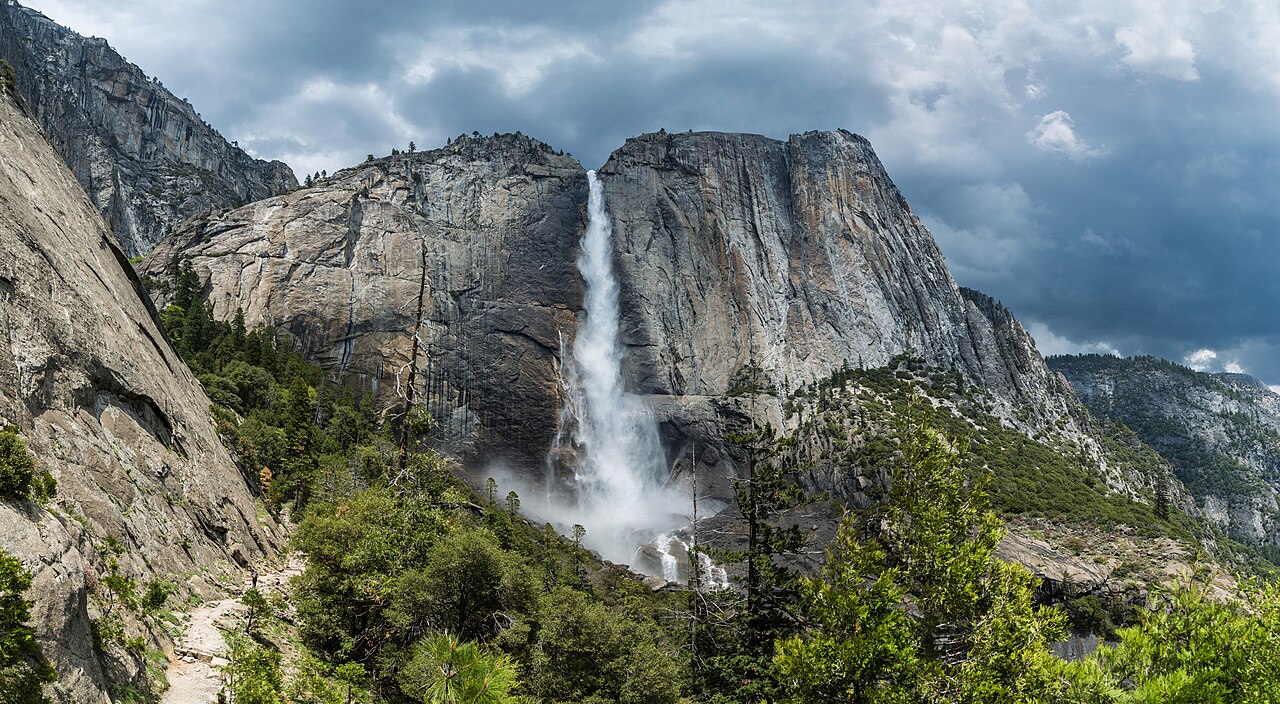
Sorted by documented height, the dataset spans a huge range. At the top sits Yosemite Falls in California at 2,425 feet — by a wide margin the tallest waterfall in the set and one of the tallest in North America. It's a tiered fall on Yosemite Creek, fed by Sierra Nevada snowmelt, which is why its documented height reflects the full upper-fall, middle-cascade, and lower-fall sequence rather than one drop. You reach the top via a strenuous 7.2-mile trail, but the base and valley views require no real hike at all.
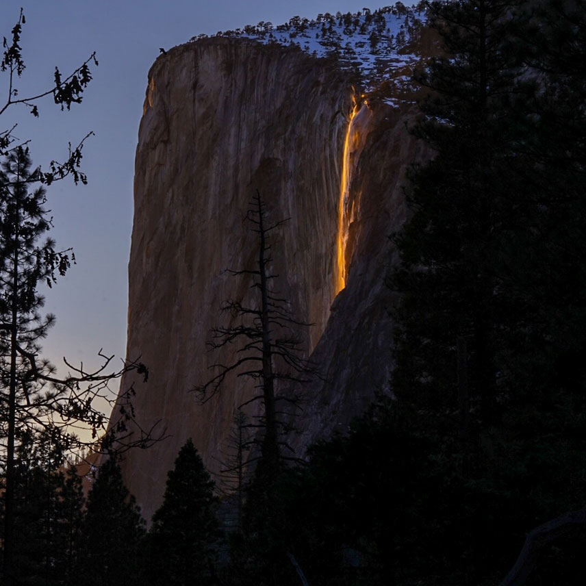
Below Yosemite, the descent is steep. Horsetail Fall, also in Yosemite, is documented at 1,570 feet — famous less for its size than for the mid-to-late-February 'firefall' effect, when the setting sun lights its thin ribbon of water orange against El Capitan, provided there's snowmelt and clear skies. Virginia's Crabtree Falls rounds out the thousand-footers at 1,000 feet, a long cascade on Crabtree Creek in the George Washington National Forest and frequently cited as the tallest waterfall east of the Mississippi. Only three of our featured falls clear 1,000 feet, and after Crabtree the numbers drop off quickly.
From there the dataset thickens into its meaty middle: Georgia's Amicalola Falls at 729 feet, Oregon's Multnomah Falls and California's Bridalveil Fall both at 620 feet, Utah's Bridal Veil Falls at 607 feet, and Yosemite's Nevada Fall at 594 feet. These are the kind of falls most people picture when they imagine a 'big' waterfall — tall enough to dominate a valley, accessible enough to visit on a day trip. The pattern is classic long-tail: a few outliers at the top, then a dense band of impressive-but-reachable falls, then a wide base of modest drops trailing down toward the bottom of the 105 ranked entries.
How Many Are Truly Tall vs. Merely Impressive
The distribution matters more than any single record. Among the falls we feature in detail here, all twelve clear 400 feet — but that's because they were selected as the headliners, not because 400 feet is typical across the full 115. The honest takeaway from the shape of the data is that genuine giants are rare. A waterfall over 1,000 feet is exceptional; a waterfall over 2,000 feet, in our set, means exactly one place: Yosemite Falls. Most documented falls in the broader dataset live well below the headline numbers, which is exactly what you'd expect from any natural-feature distribution where a few extremes pull the top of the chart far above the median.
It's also worth separating 'tall' from 'famous,' because they aren't the same thing. Multnomah Falls (620 ft) is one of the most-photographed waterfalls in the country and sits a 0.2-mile walk from a parking lot in the Columbia River Gorge — its fame comes from accessibility and a postcard footbridge, not from topping the height chart. Bridalveil Fall in Yosemite (620 ft) shares the same height and similar fame for the same reason. Meanwhile Bird Woman Falls in Montana's Glacier National Park, documented at 560 feet, hangs in a high cirque visible from the Going-to-the-Sun Road, yet draws a fraction of the foot traffic because there's no maintained trail to its base at all.
Hawaii contributes two of the most striking entries in the tropical-plunge category: ʻAkaka Falls (442 ft), a single sheer plunge of Kolekole Stream reached by a short 0.4-mile paved loop in ʻAkaka Falls State Park, and Waimoku Falls (400 ft) in Haleakalā National Park, the turnaround payoff of the roughly 4-mile Pīpīwai Trail through bamboo forest. Both are 'plunge' types, meaning their documented heights describe something much closer to a true single vertical drop than the cumulative cascade figures up the chart — a useful reminder that two falls with similar numbers can be very different experiences depending on type.
Where the Tall Ones Are: A Geography of Giants
The dataset covers waterfalls across 32 states, but the top of the height chart is not evenly spread. California dominates the upper ranks, and within California, Yosemite National Park alone supplies a remarkable cluster: Yosemite Falls (2,425 ft), Horsetail Fall (1,570 ft), Bridalveil Fall (620 ft), and Nevada Fall (594 ft) are all NPS-managed features inside a single glacially carved valley. That concentration isn't an accident of our sampling — it reflects the real geology of the Sierra Nevada, where hanging valleys left by Ice Age glaciers create exactly the high, sheer lips that produce great waterfalls.
Outside California, the giants scatter by terrain rather than by region. The Pacific Northwest's Columbia River Gorge gives us Multnomah Falls (620 ft). The southern Appalachians, which dominate the eastern half of the country's waterfall map, supply Virginia's Crabtree Falls (1,000 ft), Georgia's Amicalola Falls (729 ft), and North Carolina's Whitewater Falls (411 ft) on the Whitewater River in the Nantahala National Forest. The Rockies contribute Utah's Bridal Veil Falls (607 ft) near Provo and Montana's Bird Woman Falls (560 ft) in Glacier. And the volcanic islands of Hawaii add their own category entirely with ʻAkaka and Waimoku.
The managing-agency mix tells the same story from another angle. The tall falls are split across the National Park Service (Yosemite, Glacier, Haleakalā), the U.S. Forest Service (George Washington, Columbia River Gorge NSA, Nantahala), and state park systems (Amicalola Falls State Park in Georgia, ʻAkaka Falls State Park in Hawaii). For trip planning, that agency label is the most actionable single fact on a waterfall's record: it tells you who sets the hours, whether there's an entrance fee, and which website carries the current trail and road status.
Most Big Waterfalls Are Easier to Reach Than You'd Think
Height and difficulty are only loosely related, and the access data makes that concrete. Across all 115 waterfalls, the breakdown is 25 roadside, 53 short-hike, 33 moderate-hike, and 4 backcountry — with zero entries left unclassified. Add the first two categories together and 78 of 115 falls, about 68 percent, are reachable with a roadside view or a short hike. Only 32 percent require a moderate hike or true backcountry travel. The portfolio of American waterfalls, at least the documented ones, skews heavily toward the casual visitor.
That holds even among the tall headliners. Bridal Veil Falls in Utah (607 ft) is flat-out roadside off Provo Canyon, and Bird Woman Falls (560 ft) is viewed roadside from the Going-to-the-Sun Road, no trail required. Multnomah Falls (620 ft) is a 0.2-mile walk; Bridalveil Fall in Yosemite (620 ft) is half a mile; Whitewater Falls (411 ft) is 0.6 miles; ʻAkaka Falls (442 ft) is a 0.4-mile loop; Amicalola Falls (729 ft) and Horsetail Fall (1,570 ft) sit at roughly a mile or less. Several of the country's most spectacular drops ask almost nothing of your legs.
The exceptions are the ones worth respecting. The four backcountry falls in the set demand real effort, and even some famous names sit behind serious climbs: reaching the brink of Yosemite Falls is a 7.2-mile haul, Nevada Fall is a 5.4-mile round trip on the Mist Trail, and Waimoku Falls is the 4-mile end of the Pīpīwai Trail. The practical lesson from the access data is to read the trail figure, not the height figure, when you plan: a 620-foot fall can be a stroller-friendly stop, while a 594-foot fall up the same drainage can be a half-day commitment.
Timing closes the loop. Most of these falls peak with spring snowmelt — roughly April through June for the Sierra and the Appalachians, a bit later (June–July) for high-elevation Glacier. The two famous exceptions prove how specific waterfall season can be: Horsetail Fall's firefall glows only in mid-to-late February under the right snow and sky conditions, and Multnomah Falls flows year-round, peaking instead in winter and spring rains rather than snowmelt. Hawaii's stream-fed plunges run on rainfall rather than a snow calendar, so their best timing tracks recent storms more than any fixed month.