The access breakdown: what 115 waterfalls tell us
Of the 115 waterfalls in this analysis, the access levels break down as follows: 25 are roadside (you can see them from or near a parking area with little or no walking), 53 require a short hike (roughly a mile or less of trail), 33 require a moderate hike (longer or steeper trail walks), and just 4 are true backcountry destinations that demand serious effort, special permits, or both. None were left unclassified — every waterfall in the set has a documented access level. That is a tidy, useful distribution, and it overturns a common assumption: most famous waterfalls are not impossibly remote. The large majority — 78 of 115, or roughly two-thirds — are either roadside or reachable on a short hike of about a mile or less.
That matters because the popular image of waterfall chasing is a sweaty, all-day slog. The data says otherwise. The single biggest category is the short hike at 53 waterfalls, which is exactly the kind of trip a reasonably fit visitor can do in a morning and still be back for lunch. Roadside falls add another 25 that are open to nearly everyone, including families with strollers and visitors with mobility limitations. Add the 33 moderate hikes and you have a long tail of more ambitious day trips. The backcountry tier is genuinely rare — only about 3.5 percent of the set — which tells you that the waterfalls requiring a permit lottery or a 20-mile round trip are the exception, not the rule.
A caveat before we go further: access categories describe the trail, not the experience. A 'roadside' classification means the viewing is easy, but parking, crowds, seasonal road closures, and shuttle systems can still complicate a visit. And reported heights in any waterfall dataset vary by source and measurement method — a single sheer drop versus the cumulative height of a multi-tier cascade can produce very different numbers. We flag specific figures below, but treat them as documented estimates rather than surveyed certainties.
Roadside falls: the 25 anyone can reach
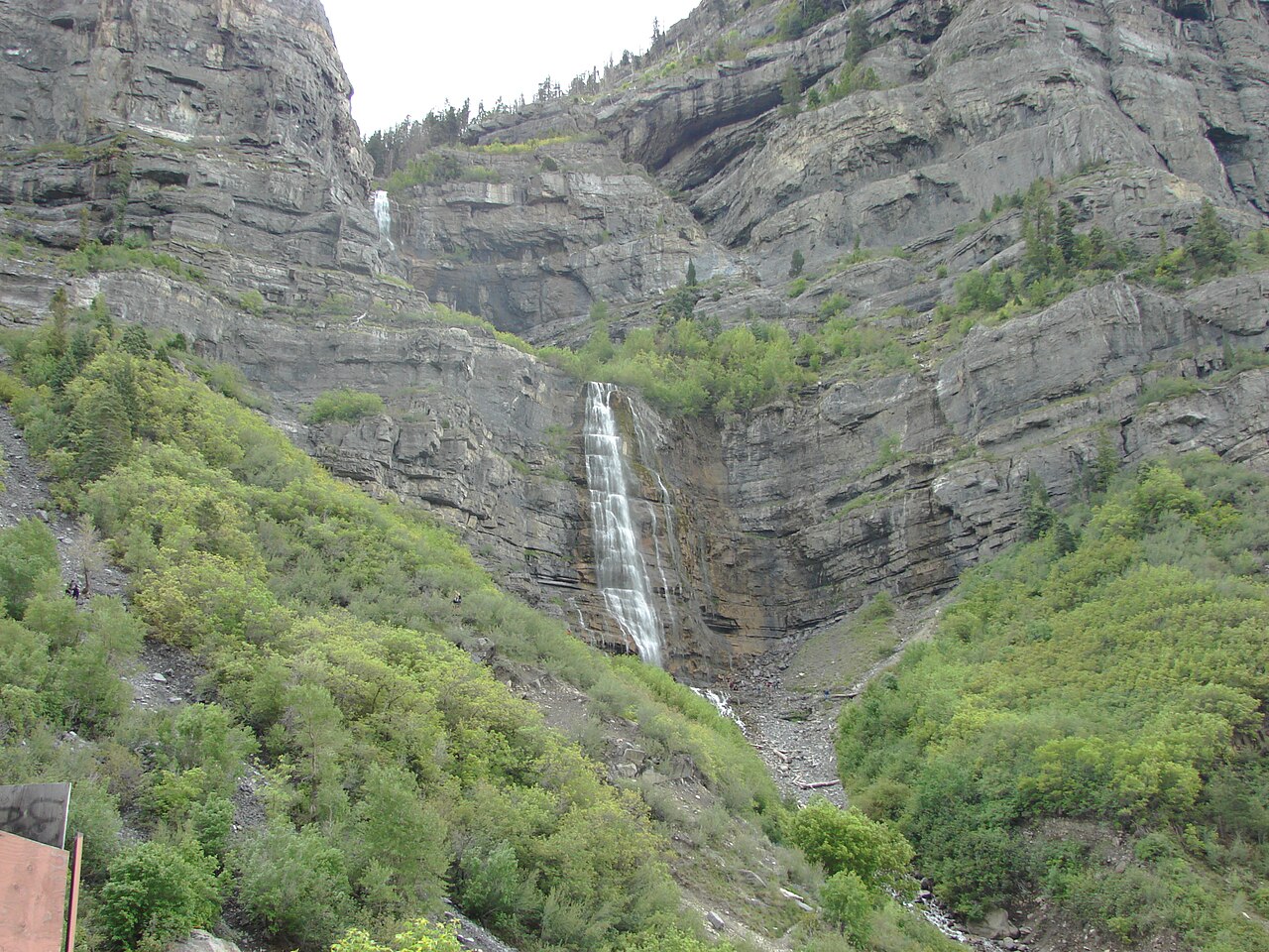
The roadside tier is where accessibility and grandeur most often overlap. Utah's Bridal Veil Falls, a tiered cascade reported at roughly 607 feet on a Provo River tributary near Provo, sits essentially at the road in Provo Canyon, with a paved path of only about 0.3 miles to the base. It is one of the most photographed waterfalls in the state precisely because it asks so little of the visitor. Spring snowmelt from roughly April through June is when it runs hardest.
Two of the most dramatic roadside falls in this set are seasonal snowmelt features in national parks. Bird Woman Falls in Glacier National Park, Montana — a horsetail-type fall reported around 560 feet on a tributary of Logan Creek — is best seen from pullouts along the Going-to-the-Sun Road during the late-spring melt in June and July; there is no trail to it, you simply view it across the valley. Salt Creek Falls in Oregon's Willamette National Forest is a 286-foot plunge on Salt Creek, reached by a paved overlook just 0.2 miles from the parking area, with peak flow during the May-June melt. Both prove that 'roadside' and 'spectacular' are not opposites.
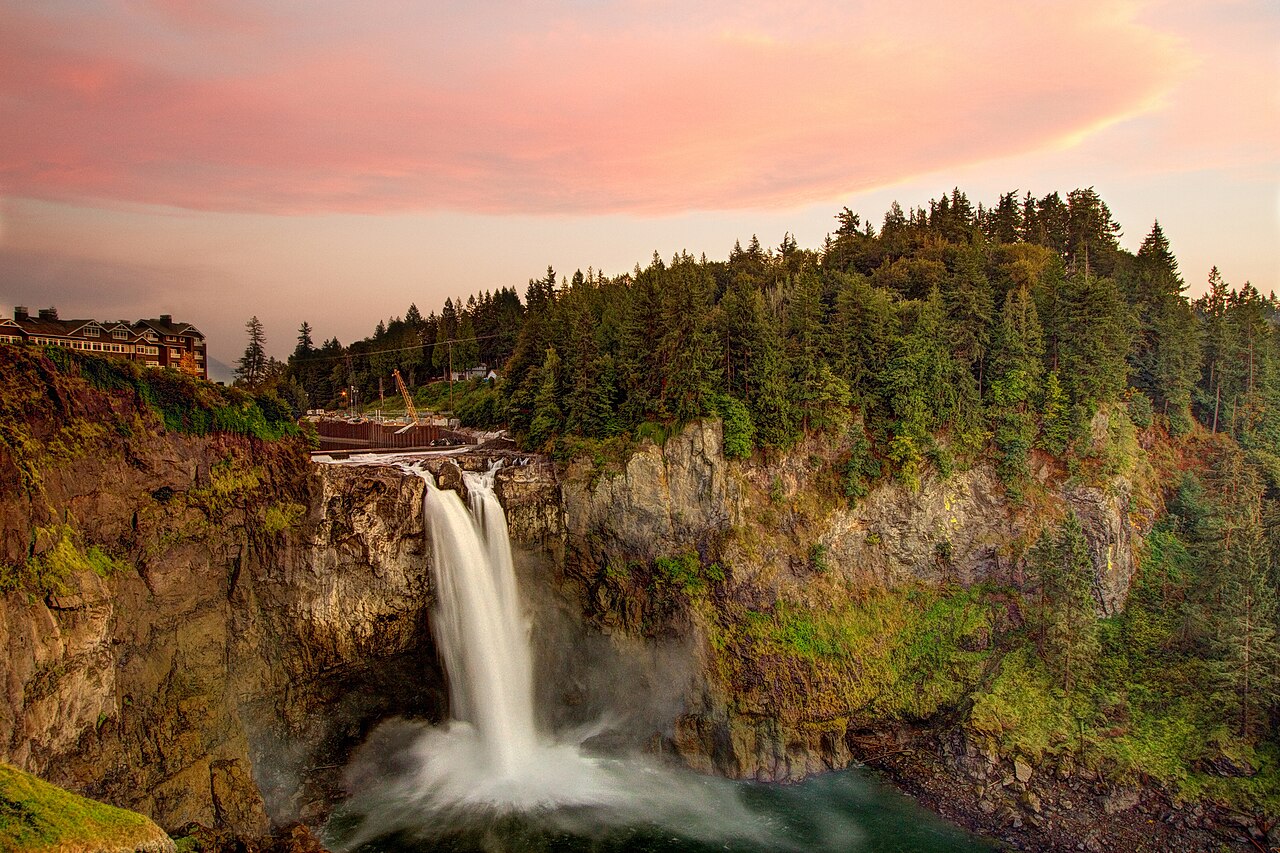
Snoqualmie Falls in Washington is the model for accessible waterfall infrastructure. The 268-foot plunge on the Snoqualmie River is owned and operated as a free public viewing park by Puget Sound Energy in cooperation with the City of Snoqualmie. The upper park is paved and ADA-accessible, with cliffside vistas roughly 100 feet from the lot — by some counts the second-most-visited natural landmark in Washington after Mount Rainier. It flows year-round, with the heaviest volume in winter and spring. For trip planners, the roadside tier is the answer to 'I want a real waterfall but I'm traveling with grandparents, a toddler, or a wheelchair.' These are the falls that deliver without negotiation.

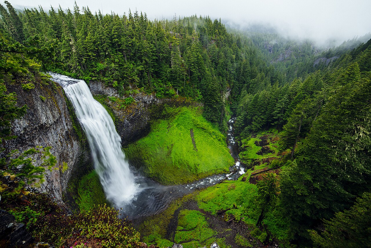
Short and moderate hikes: the 86 waterfalls that reward a little effort
The combined short-hike (53) and moderate-hike (33) tiers are the heart of the dataset — 86 of 115 waterfalls, or about three-quarters of the set. This is the sweet spot for most travelers: enough of a walk to thin the crowds and earn the view, but not so much that it requires backcountry gear or a permit. Multnomah Falls in Oregon's Columbia River Gorge is the archetype. The 620-foot tiered fall — measured as 542 feet for the upper drop, 9 feet between tiers, and 69 feet for the lower — is fed by springs from Larch Mountain and flows year-round. A paved path of roughly 0.2 miles takes you to the Benson Footbridge, which crosses about 105 feet above the lower cascade. It is technically a short hike, yet it draws more than two million visitors a year.
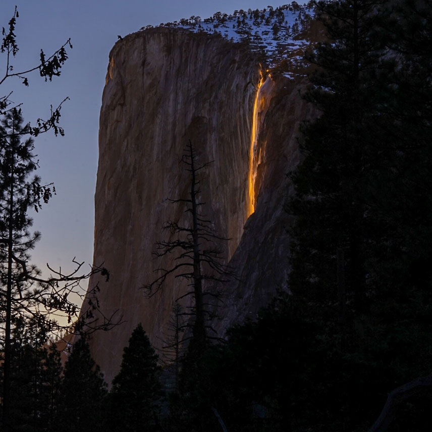
Yosemite National Park supplies two instructive short-hike examples that share a confusingly similar name. Bridalveil Fall (one word, on Bridalveil Creek) is a 620-foot plunge reached by a roughly half-mile trail, best during the April-June snowmelt. Horsetail Fall (two words, on Horsetail Creek) is the famous 'firefall' — a horsetail-type fall reported at about 1,570 feet down the east face of El Capitan, reached by a walk of roughly 1.5 miles. For about two weeks in mid-to-late February, if the fall is flowing and the western sky is clear at sunset, the setting sun lights it orange for roughly ten minutes. It is a short hike with an extraordinarily narrow window — proof that 'easy to reach' does not always mean 'easy to time.'
Amicalola Falls in Georgia rounds out the picture from the Southeast. The 729-foot tiered cascade on Amicalola Creek, managed by Amicalola Falls State Park, sits within a state-park system that has built stairs, trails, and overlooks at multiple effort levels — a roughly one-mile trail option gets you the full experience, and it runs best in spring and after heavy rain. The lesson of this tier is planning leverage: a modest investment in walking dramatically expands the menu of waterfalls available to you, and state-park and national-forest infrastructure usually means clear signage, real trails, and restrooms at the trailhead.
Backcountry: the 4 that demand a real commitment
Only 4 of the 115 waterfalls fall into the backcountry tier, and they are backcountry for different reasons — a useful distinction when you are deciding how to spend limited vacation days. Three of the four are gated by distance and permits; one is gated by access rights. Together they represent the small slice of American waterfalls that genuinely require advance logistics, not just good hiking boots.
Arizona's Havasu Falls and Mooney Falls, both plunge waterfalls on Havasu Creek managed by the Havasupai Tribe, are the classic permit-and-mileage backcountry trip. Reaching them means roughly 20 miles round trip to Havasu Falls and about 22 to Mooney, descending into the Grand Canyon past the village of Supai. Permits are released annually, are typically sold as multi-night reservations, and routinely sell out within hours or even minutes. Mooney, at about 200 feet, is the taller of the two; Havasu, at about 100 feet, is the more photographed turquoise icon. These are not day hikes — they are planned trips, and the permit is harder to get than the trail is to walk.
Alamere Falls in California is a different flavor of backcountry. The roughly 40-foot tiered fall on Alamere Creek is a 'tidefall' that drops onto the beach at Point Reyes National Seashore, reached by an unmaintained spur off roughly a 13-mile round-trip route, best in the wetter Dec-April months. Mānāwaiopuna Falls in Hawaii — the 400-foot plunge made famous as 'Jurassic Falls' — represents the access-rights category: it sits on private land on Kauai near ʻEleʻele with no public trail, so the documented way to see it is by helicopter rather than on foot. For trip planners, the backcountry tier is where you stop asking 'how long is the trail?' and start asking 'can I even get permission, and when does the booking window open?'
What the access data means for trip planning
Translate the distribution into a planning rule and it becomes practical. If you are traveling with anyone who cannot or does not want to hike — young kids, older relatives, visitors with mobility needs — the 25 roadside falls (about 22 percent of the set) are your whole world, and they are not consolation prizes. Bridal Veil Falls in Utah, Salt Creek Falls in Oregon, and Snoqualmie Falls in Washington are large, dramatic, and reachable on paved paths measured in tenths of a mile. Build a roadside-only itinerary and you sacrifice solitude, not spectacle.
If you are a typical day-hiking visitor, the math is generous. The 53 short hikes plus 33 moderate hikes give you 86 waterfalls — the overwhelming majority of the set — reachable on foot in a single day with standard gear. The strategic move here is timing, not distance. Many of these falls are snowmelt-fed and peak in a narrow spring window (Multnomah is a year-round exception; Yosemite's Bridalveil Fall and Horsetail Fall are not), so the binding constraint is usually season, not trail length. Check expected flow before you check trail mileage.
Only when you reach the 4 backcountry falls does the planning calculus invert. Here the trail is almost an afterthought next to the gatekeeping: Havasupai permits sell out in minutes, helicopter access is required for Mānāwaiopuna, and even 'free' backcountry like Alamere depends on tides, weather, and an unmaintained route. The honest takeaway from 115 waterfalls is reassuring: the famous ones are mostly attainable. Roughly 96 percent of this set asks for nothing more than a willingness to walk, and a clear majority asks for barely a walk at all. Reserve your permit-lottery energy for the rare 4 that truly require it, and treat the rest as a matter of picking the right season and lacing up.