Why "tallest" means something different in the East
Out West, the famous waterfalls fall. Yosemite Falls, Multnomah, Bridalveil — these are long, clean drops where water leaves a cliff and reappears in a pool far below, and the height is easy to picture. The eastern United States almost never works that way. The Appalachians are old, rounded mountains drained by streams that lost their straight cliffs to a few hundred million years of erosion. What remains are cascades: water sliding, bouncing, and stair-stepping down a long bedrock slope rather than free-falling through open air. So when an eastern site advertises itself as the "tallest" waterfall, the first question is always the same one — tallest measured how?
There are really two competing definitions in play, and almost every regional bragging right hinges on which one a source chose. The first is total or cumulative height: you stand at the top of the highest cascade and the bottom of the lowest and measure the vertical distance between them, counting every drop and every sliding section in between. By that definition the winners are sprawling mountainside cascades like Crabtree Falls in Virginia, whose combined drops are often cited near 1,000 feet. The second definition is the single tallest drop — one continuous fall, top to bottom, with no ledge interrupting it. By that measure the eastern champion is something far more modest in total footprint, like Taughannock Falls in New York at 215 feet, which beats Niagara's height in one unbroken sheet.
This guide ranks by documented height as reported by the managing agency or standard references, but it flags the definition behind every number. A 729-foot cascade and a 215-foot plunge are not really competing in the same event, and treating them as if they were is how the internet ends up with five different waterfalls all called "the tallest in the East." Heights below come from the U.S. Forest Service, the National Park system, state parks, and standard references; where a figure is disputed, the dispute is noted rather than smoothed over.
The Southern Appalachian giants: Crabtree, Amicalola, Whitewater
The three biggest height claims in the East all cluster in the southern Appalachians, where the Blue Ridge Escarpment — a steep elevation break between the high mountains and the Piedmont below — gives streams the vertical relief to drop hundreds of feet. Crabtree Falls in Virginia tops the list on the cumulative measure. Sitting in the George Washington National Forest above the town of Montebello, it is a chain of five major cascades and several smaller ones strung over roughly half a mile of mountainside, with combined drops commonly reported around 1,000 feet (some sources say closer to 1,200). The Crabtree Falls Trail climbs about 3.4 miles to the upper viewpoints and is rated strenuous; spring snowmelt from April into June is when the creek runs hardest. Note that there is a more famous Crabtree Falls in North Carolina off the Blue Ridge Parkway — this is the larger Virginia one.
Amicalola Falls in Georgia is the height champion of the Deep South and arguably the most accessible giant on this list. At 729 feet on Little Amicalola Creek, it is the tallest cascading waterfall in Georgia and is frequently billed as the tallest cascade east of the Mississippi — a claim it shares, and sometimes loses, to Crabtree depending on the source and the math. Inside Amicalola Falls State Park near Dawsonville, a roughly 1-mile network of trails and a famous 600-plus-step staircase carry you alongside the full height of the falls, with the best flow in spring (March through May) and after heavy rain. The park also anchors the approach trail to Springer Mountain, the southern terminus of the Appalachian Trail.
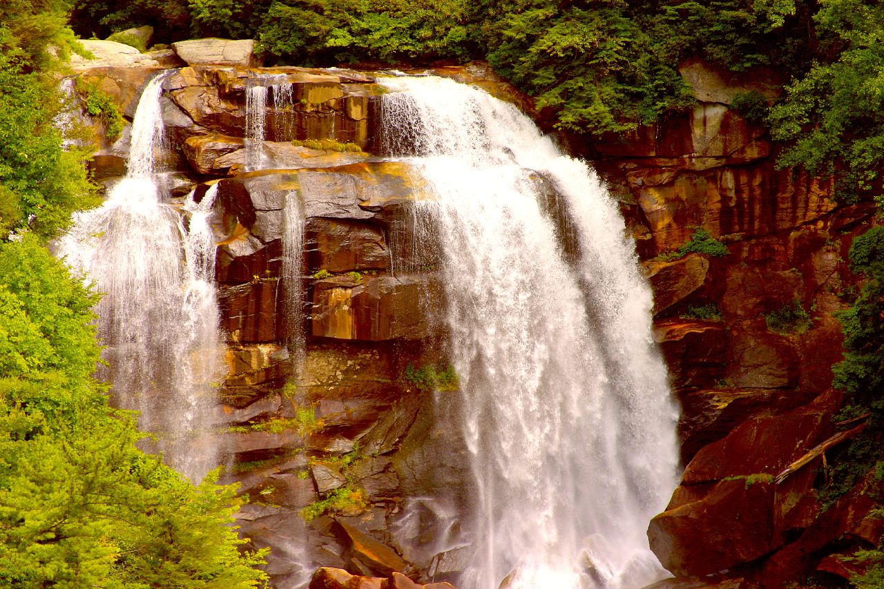
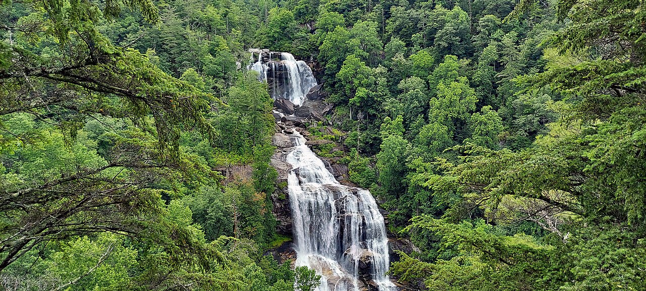
Whitewater Falls, straddling the North Carolina–South Carolina line on the Whitewater River, is the one most often crowned "the highest waterfall east of the Rockies." The Upper Whitewater Falls on the North Carolina side, in the Nantahala National Forest, is reported by the Forest Service at 411 feet, reached by a short paved path of about half a mile from the parking area near Sapphire and Cashiers. Spring snowmelt and post-rain flow are the showstoppers. The honest caveat: the 411-foot figure is the Forest Service's, and waterfall researchers generally believe the true drop is somewhat less, perhaps in the 350–400-foot range — which is exactly the kind of measurement gap that makes "highest in the East" a contested title rather than a settled fact.
The single-drop record and the free-fall record
If you set aside cumulative cascades and ask which eastern waterfall has the tallest single, unbroken vertical drop, the answer leaves the mountains entirely and lands in the Finger Lakes of New York. Taughannock Falls, in Taughannock Falls State Park near Trumansburg, drops 215 feet in one continuous plunge — about 50 feet taller than Niagara — making it the tallest single-drop waterfall east of the Rocky Mountains. The gorge that frames it is nearly 400 feet deep, carved through soft shale and limestone, and the flat, accessible Gorge Trail (about 1.5 miles round trip, easy) walks you straight to the base. Flow is strongest with spring snowmelt from April into June; by late summer the plunge can thin to a ribbon.
A close relative of the single-drop claim is the free-fall record, and here Tennessee enters. Fall Creek Falls, in Fall Creek Falls State Park near Spencer on the Cumberland Plateau, is widely cited at 256 feet of sheer free fall into the Cane Creek Gorge — long advertised as the tallest free-falling waterfall east of the Mississippi. Unlike most eastern falls it runs year-round, partly fed by an upstream impoundment, with winter and spring after rain (December through April) the most dramatic. The overlook is a short walk, but the trail to the base is steep and rated strenuous. The asterisk is a big one: the 256-foot figure is the traditional measurement, and a climber's tape-drop plus LiDAR-derived terrain models have put the actual drop substantially lower — on the order of 178 to 203 feet — so the "256" you see on signs is best read as a historical figure, not a surveyed one.
These two — Taughannock's plunge and Fall Creek's free fall — are the East's answer to the western postcard waterfall. They are shorter than the southern cascades but more visually startling, because all the height happens at once. They also illustrate why the regional records contradict each other: Whitewater can be "highest east of the Rockies" on cumulative height while Taughannock is "tallest single drop east of the Rockies" at less than half the number, and both statements are true under their own definitions.
The Northeast's tall cascades: Catskills, Adirondacks, and New England
New York's mountains hold more of the East's tall waterfalls than any other state, and not just at Taughannock. In the Catskills, Kaaterskill Falls drops a combined 260 feet in two tiers on Spruce Creek between Haines Falls and Palenville — an upper fall of about 175 feet into a stone bowl, then a second ledge of roughly 85 feet. It is one of the oldest tourist attractions in America, painted by Thomas Cole and the Hudson River School in the 1820s, and is reached by a moderate trail of about 1.4 miles; spring snowmelt is the high-water season. In the Adirondacks, OK Slip Falls is one of the range's tallest at roughly 250 feet, hidden in the Hudson Gorge Wilderness and inaccessible to the public until the state acquired the land in 2013; the trail runs about 6.4 miles round trip with modest elevation change, best in spring and early summer at high flow.
Two more Adirondack-region falls round out New York's tall list. Roaring Brook Falls, on the flank of Giant Mountain near Keene Valley in the Giant Mountain Wilderness, tiers down roughly 270 feet and is unusually easy to reach — a short walk delivers the base view, with spring and early summer the strongest flow. The contrast across these New York falls is instructive: a 270-foot tiered cascade you can almost drive to, a 250-foot plunge that took a state land deal to open, and a 215-foot single drop in a developed state park all sit within a few counties of one another.
New England's tallest falls are nearly all long, narrow cascades on steep mountain brooks. In New Hampshire's White Mountains, Nancy Cascades tiers down about 300 feet on Nancy Brook, reached by a moderate 5-mile trail and at its best from late spring through fall. Just off the road in Crawford Notch State Park, Silver Cascade slides roughly 250 feet down Silver Cascade Brook in full view of the highway — a rare roadside giant, best in spring snowmelt. Massachusetts contributes Race Brook Falls, a tiered cascade of about 300 feet near Sheffield in the Mount Everett State Reservation, on a strenuous 3.9-mile trail that connects to the Appalachian Trail. Maine's Step Falls, a 250-foot cascade on Wight Brook protected by the Mahoosuc Land Trust near Newry, and Connecticut's Kent Falls, a 250-foot series of cascades in Kent Falls State Park, both prove the pattern holds north and south: the Northeast's "tall" waterfalls are measured down the length of a tumbling slope, not across an open cliff.
The Carolinas escarpment and how to read any height claim
Back along the Blue Ridge Escarpment, South Carolina's tallest is Raven Cliff Falls, an estimated 400 feet (some sources say closer to 420) on Matthews Creek inside Caesars Head State Park and the Mountain Bridge Wilderness near Cleveland. It is distinctive for plunging through a narrow rock cleft rather than spilling over an open ledge, and reaching the overlook is a moderate 4.4-mile round-trip hike; a swinging suspension bridge above the falls rewards those willing to add miles. Like its escarpment neighbor Whitewater, its exact height is an estimate, not a survey — which is the rule, not the exception, for eastern falls.
That is the real takeaway for anyone comparing these numbers. Almost every eastern height you will read is one of three things: a cumulative cascade measurement (Crabtree, Amicalola, Raven Cliff, most of New England), a single-drop or free-fall figure (Taughannock, Fall Creek Falls), or an agency estimate that predates modern surveying (Whitewater's 411 feet, Fall Creek's 256). When two sources disagree, they are usually not in conflict so much as answering different questions or relying on different vintages of measurement. The World Waterfall Database and similar references increasingly publish LiDAR-checked drops that run lower than the traditional signage, which is why "the tallest waterfall in the East" has no single, undisputed answer.
Practically, that means you can pick your champion by what you actually want to see. For sheer scale on a mountainside, head to Crabtree Falls or Amicalola Falls. For a single curtain of water taller than Niagara, go to Taughannock Falls. For the classic free-fall plunge, Fall Creek Falls (with the caveat that the famous 256-foot number is generous). For the highest-flagged drop in the region, Whitewater Falls. And whichever you chase, go in spring: nearly every waterfall on this list peaks with April-into-June snowmelt or right after heavy rain, and the same falls that overwhelm you in May can shrink to a trickle by August.
