Why the Interior Highlands Are a Wet-Weather Waterfall Region
The Ozark Plateau and the Ouachita Mountains form the Interior Highlands, the only major mountainous uplift between the southern Appalachians and the Rockies. They are not high — the tallest summits barely clear 2,700 feet — but they are deeply dissected, with sandstone and dolomite bluffs that streams have carved into hollows, box canyons, and pour-offs. Wherever water finds an edge of resistant rock above a softer layer, it makes a waterfall. Arkansas alone has hundreds of documented falls, and Missouri and Oklahoma add their own clusters along the Ozark rim.
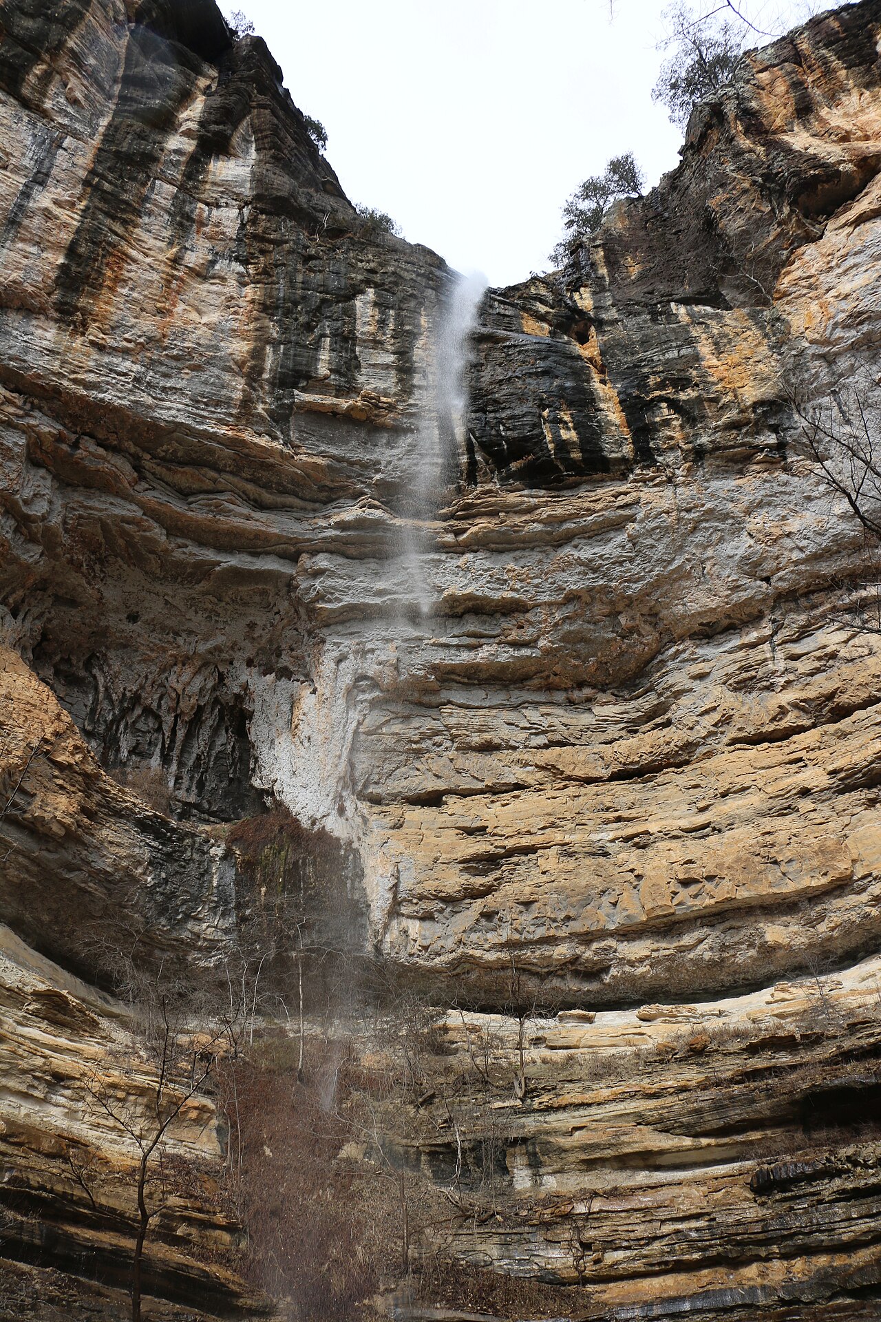
The catch is hydrology. Most of these falls are not spring-fed, perennial cataracts. They depend on surface runoff from intermittent and ephemeral streams, which means their flow tracks recent rainfall almost in real time. Hemmed-In Hollow Falls in Arkansas drops 209 feet — taller than any waterfall in the lower Midwest — yet it pours from an intermittent stream in the Buffalo River drainage and can be a faint stain on the cliff in a dry August. Mina Sauk Falls in Missouri, the state's highest at roughly 132 feet, is explicitly a wet-weather falls fed by Taum Sauk Creek; the Missouri State Parks describe it as best after heavy rain.
That is why timing matters more here than almost anywhere else in the country. The reliable window runs from late winter through spring — broadly December through April in the southern Ozarks, peaking March through May with snowmelt and frontal rains. Plan a trip around a recent storm and you may see a 200-foot ribbon at full volume. Show up on a sunny week in July and the same overlook can deliver bare rock. A few exceptions — Turner Falls and Natural Falls in Oklahoma, both partly or wholly spring-fed — hold water far better, which is exactly why they anchor the dry-season list.
The Tall Ones: Hemmed-In Hollow and Mina Sauk
Hemmed-In Hollow Falls (slug hemmed-in-hollow-falls-ar) is the headline act of the entire region. At 209 feet it is a single plunge off a sandstone amphitheater in the Buffalo National River backcountry, managed by the National Park Service near Ponca, Arkansas. Reported heights are consistent around 209 feet, but as with all tall plunges the figure reflects the full free-fall of the lip rather than any cumulative measurement, so treat it as approximate. There is no easy way in: the common routes are strenuous backcountry hikes of roughly 5 to 5.7 miles round trip, some involving steep descents into the hollow or longer approaches from the Compton trailhead. Go after rain, and go prepared — there is no shortcut to a falls this remote.
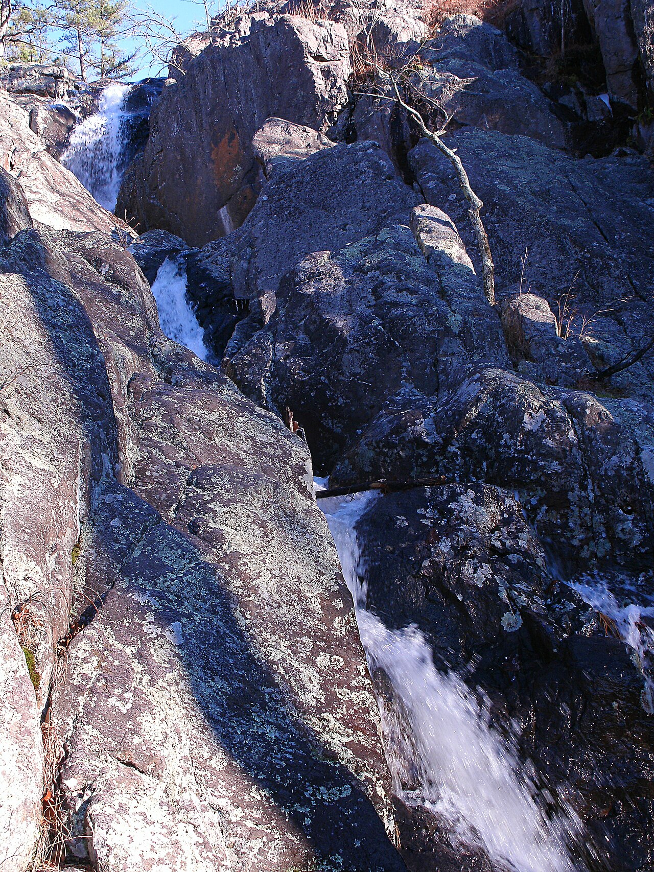
Mina Sauk Falls (slug mina-sauk-falls-mo) is Missouri's tallest, a tiered drop of about 132 feet on Taum Sauk Creek inside Taum Sauk Mountain State Park near Ironton. Because it tumbles in steps down the flank of the state's highest mountain rather than free-falling, its height is a cumulative figure across multiple ledges, and individual sources may count the cascade differently. The reward is a roughly 3-mile loop on the rugged Mina Sauk Falls Trail, rated strenuous over the park's igneous shut-ins terrain. State Parks are blunt that this is a wet-weather feature — visit in spring or within a day or two of heavy rain for the full tiered show, or you may find the ledges nearly dry.
Both falls illustrate the regional pattern: the tallest drops are the most rain-dependent, because the streams feeding them drain small upland catchments with little baseflow. A 200-foot cliff concentrates whatever water is available into a dramatic line, but it cannot manufacture water that the watershed has not received. The height that makes them spectacular is the same height that makes them ephemeral.
The Arkansas Ozark Classics: Kings Bluff, Cedar Falls, Eden Falls, and More
Arkansas's Ozark-St. Francis National Forest and state parks hold a dense cluster of mid-sized falls that reward a spring weekend. Kings Bluff Falls (slug kings-bluff-falls-ar) near Pelsor is a roughly 114-foot plunge in the national forest, reached by an approachable 1.7-mile moderate loop — a lot of vertical drop for relatively little effort, best in winter and spring after rain. Cedar Falls (slug cedar-falls-ar) in Petit Jean State Park near Morrilton is one of the most photographed waterfalls in the state, a 95-foot plunge on Cedar Creek reached by a 2.2-mile moderate hike into the canyon, at its strongest with spring snowmelt and rains from March through May.
Closer to the Buffalo River, Lower Eden Falls (slug eden-falls-lower-ar) is an accessible 53-foot tiered falls on Clark Creek near Ponca, on the Lost Valley Trail — an easy 2.4-mile out-and-back that is one of the best family-friendly hikes in the region, with strongest flow in spring. Pam's Grotto Falls (slug pam-s-grotto-falls-ar) near Hagarville is a 37-foot plunge on a Haw Creek tributary in the national forest, a 1-mile moderate hike that drops into a mossy grotto and shines in the March-to-May rains. For something gentler, Bridal Veil Falls (slug bridal-veil-falls-ar) at Heber Springs is a 50-foot cascade reached by a short but steep 0.3-mile scramble, best in spring after rain.
Two more Arkansas entries round out the spread. Triple Falls — also called Twin Falls at Camp Orr (slug triple-falls-twin-falls-at-camp-orr-ar) — near Jasper is a 48-foot segmented falls on Rock Bridge Creek in the Buffalo National River vicinity, an easy 0.4-mile approach that, being partly spring-fed, holds at least some flow beyond the strict wet-weather window. And in the Ouachitas, Cossatot Falls (slug cossatot-falls-ar) near Wickes is a 33-foot series of drops on the Cossatot River inside Cossatot River State Park-Natural Area; a 0.9-mile moderate walk reaches it, and at high water it becomes a serious Class IV-V whitewater run rather than a quiet photo stop.
A note on the names and numbers: several of these falls carry alternate names (Triple Falls vs. Twin Falls, Natural Falls vs. Dripping Springs Falls) and slightly different reported heights and trail distances depending on the source. Where a cascade descends in steps, a height may represent the total drop rather than a single plunge, so the figures here are best read as documented approximations, not surveyed measurements.
Oklahoma and Missouri: Spring-Fed Reliability and Roadside Ease
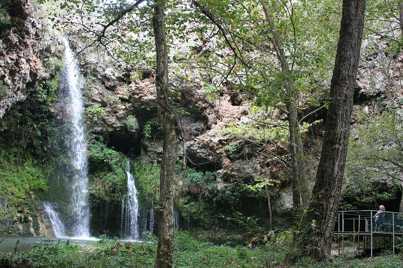
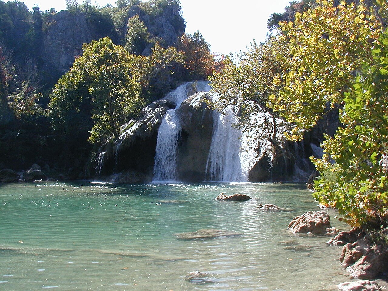
Oklahoma's two marquee falls sit on the western edge of the highlands and break the wet-weather rule, which makes them the safest dry-season bets in the region. Turner Falls (slug turner-falls-ok) in the Arbuckle Mountains near Davis is a 77-foot fan-shaped falls on Honey Creek inside Turner Falls Park, operated by the City of Davis; a short 0.5-mile easy walk reaches the base, and because Honey Creek carries reliable flow it runs well from spring straight through summer, when swimming in the plunge pool is the main draw. Natural Falls (slug natural-falls-ok) near West Siloam Springs is a 77-foot plunge in Natural Falls State Park, reached by a short 0.9- to 1.1-mile loop; it is spring-fed (its older name, Dripping Springs Falls, slug natural-falls-dripping-springs-falls-ok, reflects this), so it holds a year-round presence and simply runs strongest in spring.
Missouri's southern Ozarks contribute two falls along the spring-rich riverways country. Rocky Falls (slug rocky-falls-mo) near Eminence is a 40-foot cascade over pink rhyolite shut-ins on Rocky Creek, within the Ozark National Scenic Riverways managed by the National Park Service. It is essentially roadside — a 0.2-mile easy walk — making it one of the most accessible scenic falls in the region, and like the rest it is at its loudest after heavy spring rain. Mina Sauk, covered above, is the state's tall counterpoint.
The lesson for trip planning is to mix the two categories. Pair an ephemeral showstopper like Hemmed-In Hollow or Mina Sauk, which demands a recent storm, with a dependable anchor like Turner Falls or Natural Falls that will deliver regardless. That way a dry spell does not ruin the trip — and a wet one turns it into something extraordinary.
Reading the Weather and Hiking Smart
Because flow tracks rainfall, the single most useful planning tool is recent precipitation data. Check the USGS streamgages and the local forecast in the days before a trip; a soaking front in the 24 to 72 hours prior is what separates a thundering 200-foot plunge from a dry cliff. The same storms that make the falls also raise river levels fast, so flash-flood awareness is essential — Cossatot Falls in particular sits on a river that can rise dramatically, and crossings elsewhere can become impassable.
Match the hike to your party honestly. The easy roadside and short-trail options — Rocky Falls (0.2 mi), Triple Falls (0.4 mi), Turner Falls (0.5 mi), Natural Falls (0.9 mi) — suit families and casual visitors. The moderate hikes — Pam's Grotto (1 mi), Kings Bluff (1.7 mi), Cedar Falls (2.2 mi) — ask for sturdy footwear and some elevation tolerance. The strenuous backcountry routes — Mina Sauk's ~3-mile loop and Hemmed-In Hollow's 5-to-5.7-mile trek — are full-day undertakings with steep, rocky terrain and should not be attempted casually, especially in wet conditions when rock is slick.
Respect the land managers and their rules. These falls span the National Park Service (Buffalo National River, Ozark National Scenic Riverways), the U.S. Forest Service (Ozark-St. Francis National Forest), three state park systems, and a city-run park. Stay on established trails, keep off undercut bluff edges that are most dangerous when wet, and follow the seasonal and access guidance each manager posts. The whole appeal of the Interior Highlands is that these are wild, weather-driven places — plan around the rain, give the tall ones a real day, and you will catch the Ozarks and Ouachitas at their best.