Why the Olympic Peninsula is its own kind of waterfall country
Most waterfall guides for a single park describe one watershed and one season. Olympic National Park does not work that way. It is a roughly million-acre park managed by the National Park Service that stretches from a coastline of sea stacks and tidepools, up through temperate rainforest valleys, to glaciated peaks that hold snow well into summer. That vertical and ecological range means the falls here are fed by very different plumbing: some by coastal rain, some by river current, some by high snowmelt. The practical upshot for a visitor is that there is almost always a good waterfall running somewhere in the park, but rarely are all of them at their best at once.
A second thing to understand before you start chasing them is that reported heights here, as everywhere, should be read as estimates rather than surveyed measurements. The figures in this guide come from the data record the park and waterfall databases publish, and they are useful for picturing the scale of a fall — a 90-foot plunge versus a 48-foot segmented drop reads very differently in person — but the exact number depends on where someone decided the fall starts and stops. Treat a height as a description, not a survey benchmark.
Olympic also rewards a particular travel pattern. The park has no single road that loops through it; instead, spur roads reach in from the U.S. 101 ring that circles the peninsula. That geography is why the falls in this guide cluster around different gateway towns — Port Angeles on the north shore, Forks and La Push on the west — rather than a single trailhead hub. Plan your day around one or two access roads rather than trying to string the whole park together, and check current road and trail status with the park before you go, since winter storms regularly close the access roads that lead to these falls.
Sol Duc Falls: the rainforest centerpiece
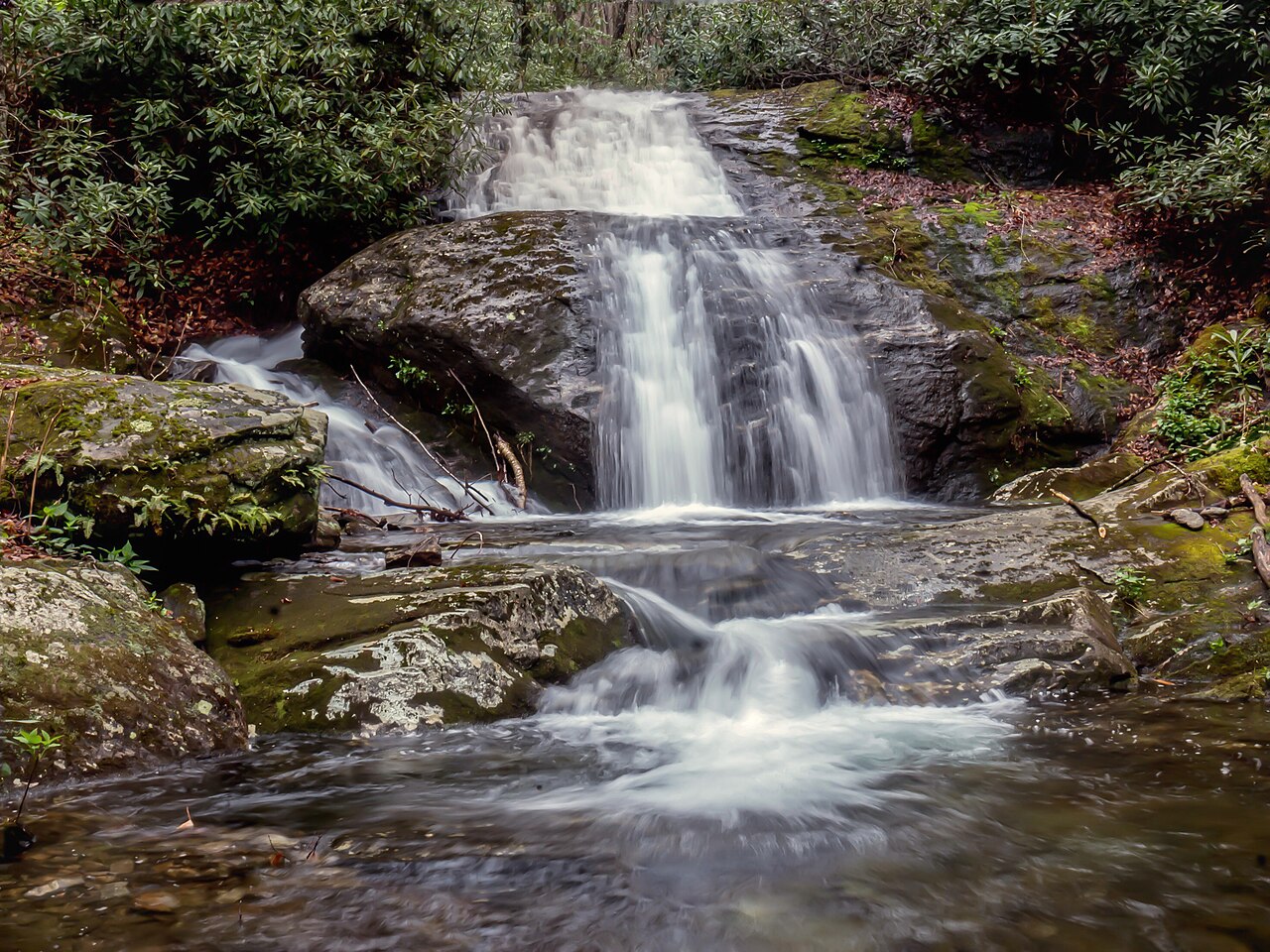
If Olympic has a signature waterfall, it is Sol Duc Falls. The Sol Duc River, swollen with rainforest runoff, splits and pours through a narrow rock cleft as a segmented fall of roughly 48 feet. Segmented means the water divides into separate channels as it goes over the lip — at high flow Sol Duc can run as three or four distinct ribbons side by side, which is what makes it so photogenic and what sets it apart from a single-curtain plunge. A footbridge crosses the gorge just downstream, giving you a head-on view into the chasm.
The hike is short and family-friendly: about 1.6 miles round trip on an easy, well-graded trail through old-growth forest from the Sol Duc trailhead at the end of the Sol Duc Hot Springs Road, which spurs south off U.S. 101 west of Lake Crescent. The trail is one of the most popular in the park, so the parking area fills early in summer; arriving in the morning or late afternoon is the difference between a quiet forest walk and a crowded one.
For flow, Sol Duc is best during spring snowmelt and the rainy season — roughly April through June and again November through January — when the river carries the most water and the segmented channels run full. In the driest stretch of late summer the fall narrows but rarely disappears, because the Sol Duc drains a large, wet basin. The Sol Duc Hot Springs Road can close for the winter season, so if you are aiming for the high-flow shoulder months, confirm the road is open before you commit the drive.
Marymere and Madison: the easy north-shore pair near Port Angeles
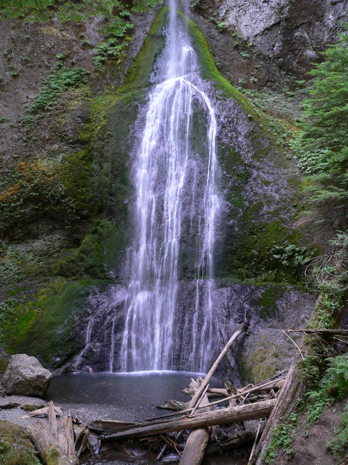
On the north side of the park, two falls make an efficient pairing for a half day out of Port Angeles, and they sit at opposite ends of the effort scale. Marymere Falls is the classic: a slender plunge of about 90 feet where Falls Creek drops over a mossy rock face deep in the forest near Lake Crescent. It is reached by an easy, roughly 1.8-mile round-trip walk from the Storm King area on the south shore of Lake Crescent, with a short, steeper set of switchbacks and viewing loops near the base. The forest is dense and the creek runs year-round, which makes Marymere one of the more dependable falls in the park to put on a list — it is worth a look in any season, though it carries the most water in spring and after rain.
Madison Falls is the opposite proposition: a horsetail of around 60 feet on Madison Creek that you reach by a paved, wheelchair-accessible path of roughly 0.2 miles from the parking area near the Elwha entrance. Horsetail means the water keeps contact with the rock as it descends, fanning out rather than free-falling. Because it is essentially roadside, Madison is the rare Olympic fall that asks almost nothing of you physically, which makes it a good stop for travelers with limited mobility, small children, or simply a tight schedule. It shows best in spring, when snowmelt and rain push the most water down Madison Creek; by late summer it can thin considerably.
Pairing these two works well because they bracket the experience: Madison for a quick, accessible look on your way in or out, Marymere for a short but genuinely scenic forest hike. Both depend on the Elwha and Lake Crescent access corridors, and the Elwha area in particular has seen recurring road washouts over the years, so it is worth checking current access to Madison Falls specifically before planning around it.
The quieter ones: Mineral Creek Falls in the Hoh and Strawberry Bay Falls on the coast
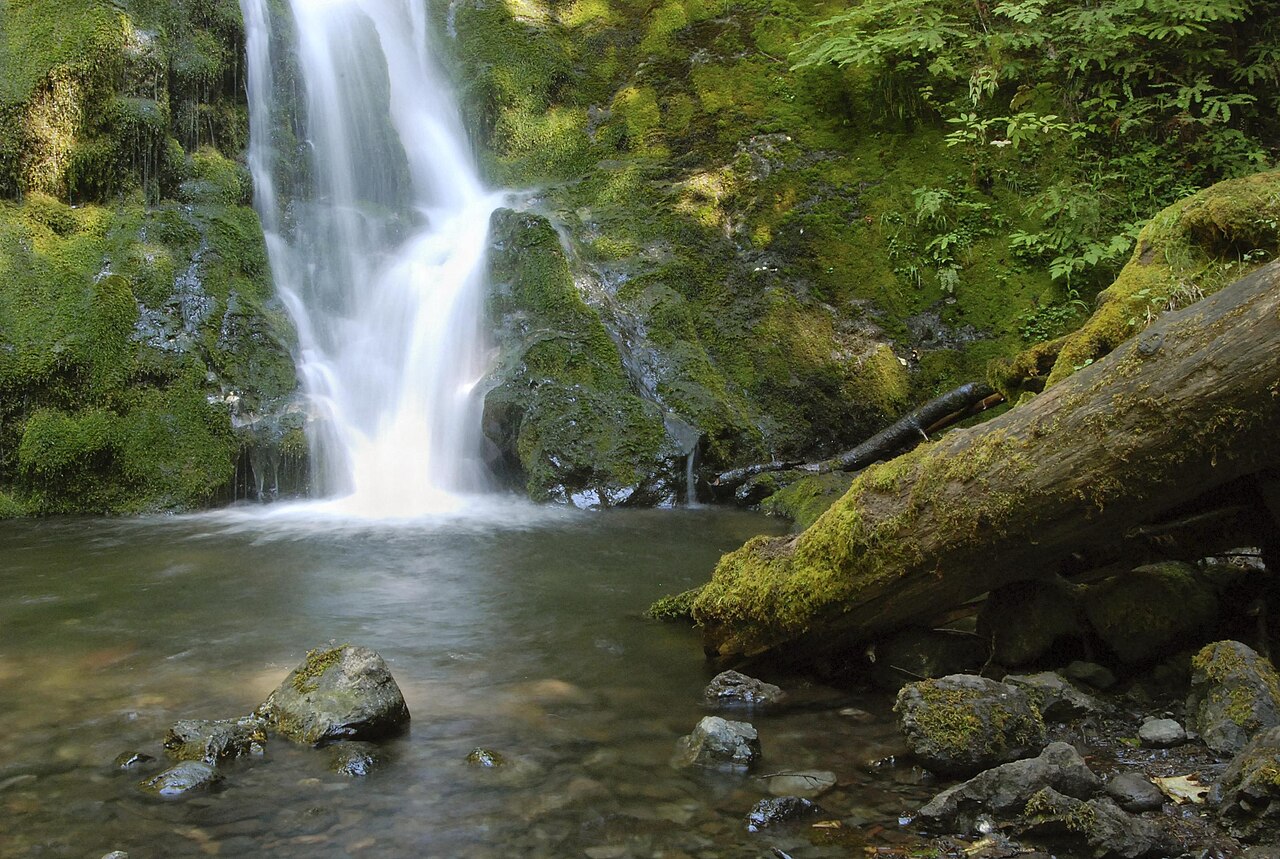
Beyond the marquee falls, Olympic hides two that reward people willing to walk a little farther — and they could not be more different from each other. Mineral Creek Falls is a cascade of about 60 feet tucked along the Hoh River Trail, the celebrated path into the Hoh Rain Forest near Forks. The walk in is roughly 5.6 miles round trip, but the trail itself is easy and nearly flat, following the river through some of the most famous temperate rainforest in the country. That combination — a long but gentle approach through moss-draped old growth — makes Mineral Creek Falls less a destination in itself than a fine turnaround point or rest stop on a Hoh River day hike. It runs fullest with spring snowmelt and holds water through fall.
Strawberry Bay Falls, also known as Third Beach Falls, is the wild card of this guide: a horsetail of roughly 100 feet that pours down a coastal bluff and is visible from the wilderness beach below, near La Push. Reaching it means a moderate hike of about 3.6 miles round trip that drops through forest to Third Beach, after which you walk the sand toward the headland to see the fall coming off the cliff. Because it is fed by a small unnamed coastal tributary rather than a major river, its flow is tied directly to coastal rain — it is at its fullest from roughly November through May, the wet season, and can shrink to a trickle in a dry summer. This is the most weather-dependent fall in the guide, and the one most worth timing to a rainy stretch.
A practical caution for Strawberry Bay Falls: it lives in Olympic's coastal wilderness, where the rules of the beach matter. Tide timing affects how easily you can move along the sand below the headland, and coastal hazards like surge and slick rock are real. Check a tide table and current conditions before you go, give the surf a wide margin, and treat the beach approach as the genuinely backcountry outing it is rather than a casual stroll.
Planning the trip: seasons, access, and a realistic order of operations
Because the park is a ring with spurs rather than a loop, the smartest way to see several of these falls is to group them by gateway. From Port Angeles on the north shore you can string together Madison Falls near the Elwha and Marymere Falls at Lake Crescent in a single relaxed half day, since both are short and lie along or just off the U.S. 101 corridor. From the west side, based out of Forks or La Push, you can pair the Hoh River Trail walk to Mineral Creek Falls with a separate outing to Strawberry Bay Falls at Third Beach, though those two are different enough in character — deep rainforest versus open coast — that many visitors give each its own half day. Sol Duc Falls sits between the two clusters, off the road west of Lake Crescent, and slots naturally into either day.
Season is the lever that changes everything. The rain- and snow-fed falls — Sol Duc, Mineral Creek, Madison — peak in spring as the high country melts out, roughly April through June, with a second strong window during the late-fall and early-winter rains for the lower-elevation falls. The coastal Strawberry Bay Falls inverts that logic somewhat: its best flow runs from the rainy months of November through May, and it can disappoint in a dry late summer. Marymere, fed by a year-round creek, is the safest pick if your dates are fixed and you simply want a reliable fall regardless of timing.
Two operational notes worth taking seriously. First, the spur roads that reach these falls — the Sol Duc Hot Springs Road, the Hoh Rain Forest Road, the Elwha access — are the park's weak points; winter storms and washouts close them with some regularity, and a closure can turn a planned waterfall into a long detour. Always confirm current road and trail status with Olympic National Park before you drive. Second, an entrance fee or pass applies to the park, and the popular trailheads (Sol Duc especially, and the Hoh) fill early in the warm season, so an early start buys you both parking and solitude.