Why the North Cascades Are Waterfall Country
The North Cascades earn their nickname — the "American Alps" — honestly. Steep, glacier-carved valleys, hundreds of inches of annual snowfall on the high peaks, and dozens of small glaciers feeding the river systems combine to produce waterfalls that are tall, loud, and almost entirely dependent on the season. Unlike the steady year-round flows of a spring-fed cascade, most North Cascades falls are snowmelt machines: they roar in late spring and early summer as the snowpack lets go, then thin out as the high country dries through August and September.
That snowmelt rhythm shapes everything about visiting them. The waterfalls featured here cluster into three distinct sub-regions: the remote Stehekin and Ross Lake country deep inside the North Cascades National Park Complex, served by Highway 20 and the Lake Chelan ferry; the Mount Baker corridor along State Route 542 in the far northwest; and the heavily visited Snoqualmie Pass area along Interstate 90, which sits at the southern doorstep of the range. Each has its own access logic, its own season, and its own kind of waterfall.
It is worth flagging up front that reported heights in this region vary widely by source and by measurement method. Mapping a tiered or segmented waterfall is genuinely hard — surveyors disagree about where one drop ends and the next begins, and whether to count the steep cascading runout below the main plunge. The numbers in this guide come from the data we track and from public sources, but treat them as good estimates rather than surveyed certainties. Where two credible figures exist, we say so.
Stehekin and Ross Lake: The Wild, Remote Tier
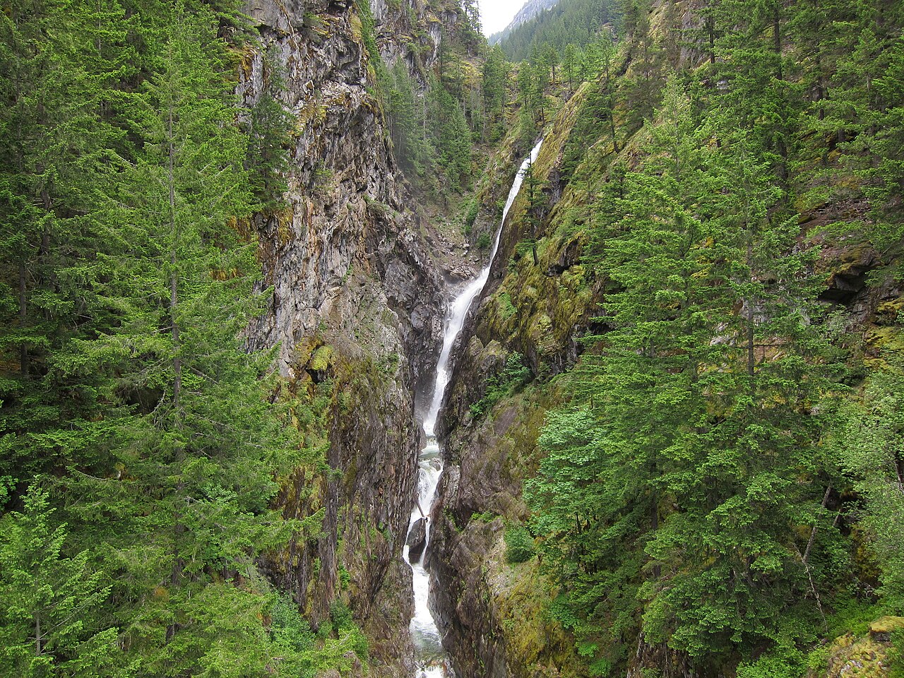
If you want the single most dramatic waterfall in this guide, you have to work for it. Rainbow Falls drops roughly 392 feet in two tiers on Rainbow Creek near Stehekin, inside the Lake Chelan National Recreation Area unit of the North Cascades complex. The catch is that Stehekin has no road to the outside world. You reach it only by boat, floatplane, or a multi-day backpacking trip over Cascade Pass — the Lady of the Lake ferry from Chelan takes roughly four hours up the lake. Once you're there, the falls are nearly effortless: a 0.1-mile walk from the Stehekin Valley Road, with a National Park Service shuttle that runs from the Stehekin dock to the falls during the summer season. The plume is at its best in May and June during peak runoff. The National Park Service lists the two-tier drop, with the upper tier accounting for the bulk of the height — about 312 feet of the total.
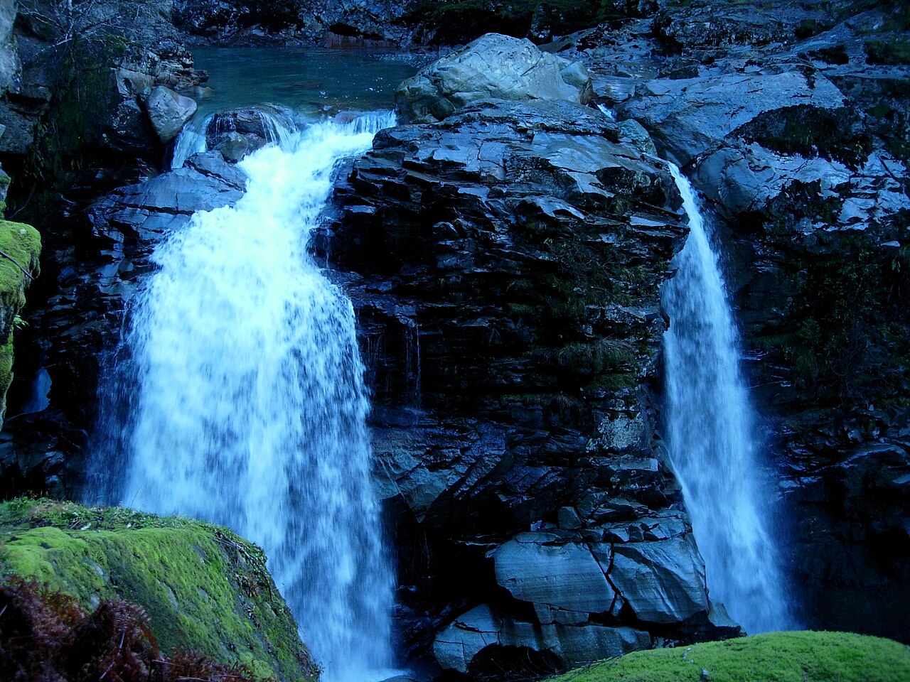
Closer to Highway 20, Gorge Creek Falls is the accessible counterpart — the wild tier without the boat ride. It sits on Gorge Creek within the Ross Lake National Recreation Area, a couple of miles east of the old company town of Newhalem, where a highway bridge spans the gorge directly above the falls. We track its height at 242 feet, though you'll see figures as high as roughly 390 feet quoted elsewhere because the creek tumbles through a series of major drops and different sources measure different sections. The parking area has accessible restrooms and a short interpretive path; the first 0.3 mile is paved and accessible, looping out to expansive views of Gorge Lake and Gorge Dam before an unpaved stretch winds back through the forest. As with everything here, flow is heaviest in spring and early summer.
One major planning note for this tier: Highway 20 (the North Cascades Highway) closes every winter, typically from late fall through mid-spring, because of avalanche danger and snow, and reopening dates shift year to year with conditions and plowing progress. If you're targeting Gorge Creek Falls or driving toward the Stehekin gateway, confirm the highway is open before you commit — the Washington State Department of Transportation and the park's road-conditions page are the authorities. The closure is also exactly why peak waterfall season and road access don't always overlap neatly: the snowpack that fuels the falls is the same snowpack that keeps the road shut.
The Mount Baker Corridor: Nooksack Falls
Drive State Route 542, the Mount Baker Highway, past the hamlet of Glacier and you reach one of the most powerful roadside waterfalls in the state. Nooksack Falls drops freely about 88 feet where the North Fork of the Nooksack River plunges into a deep, rocky canyon. The North Fork gathers its water from East Nooksack Glacier on the flanks of Mount Baker, so this is glacier-and-snowmelt flow at its rawest — the falls run hardest during spring melt, roughly April through June. It sits within the Mount Baker-Snoqualmie National Forest, and reaching the viewpoint is trivial: a short drive off the highway (a fraction of a mile down a forest road) and a brief walk of about 0.1 mile to a fenced overlook above the brink.
That fence matters, and it is the most important thing to know about Nooksack Falls. The rock around the gorge is slick, the drop is sheer, and the falls have a grim history — by some accounts at least 11 people, most of them teenagers and young adults, have died here since the 1940s, nearly all while trying to scramble out for a better view. A chain-link fence, prominent warning signs, and a memorial near the parking lot exist precisely because of that record. There is no safe way to reach the base from the road above. The view from behind the fence is genuinely spectacular; treat it as the only view worth taking.
Nooksack Falls also carries a thread of local history that's worth knowing. The falls appear in the hunting sequence of the 1978 film The Deer Hunter, and the surrounding area saw a gold-mining boom in the late 19th century — the Lone Jack Claim of 1897 was the richest strike in the district. None of that changes the safety calculus, but it gives the overlook more texture than a typical roadside stop.
Snoqualmie Pass: Franklin Falls and Keekwulee Falls
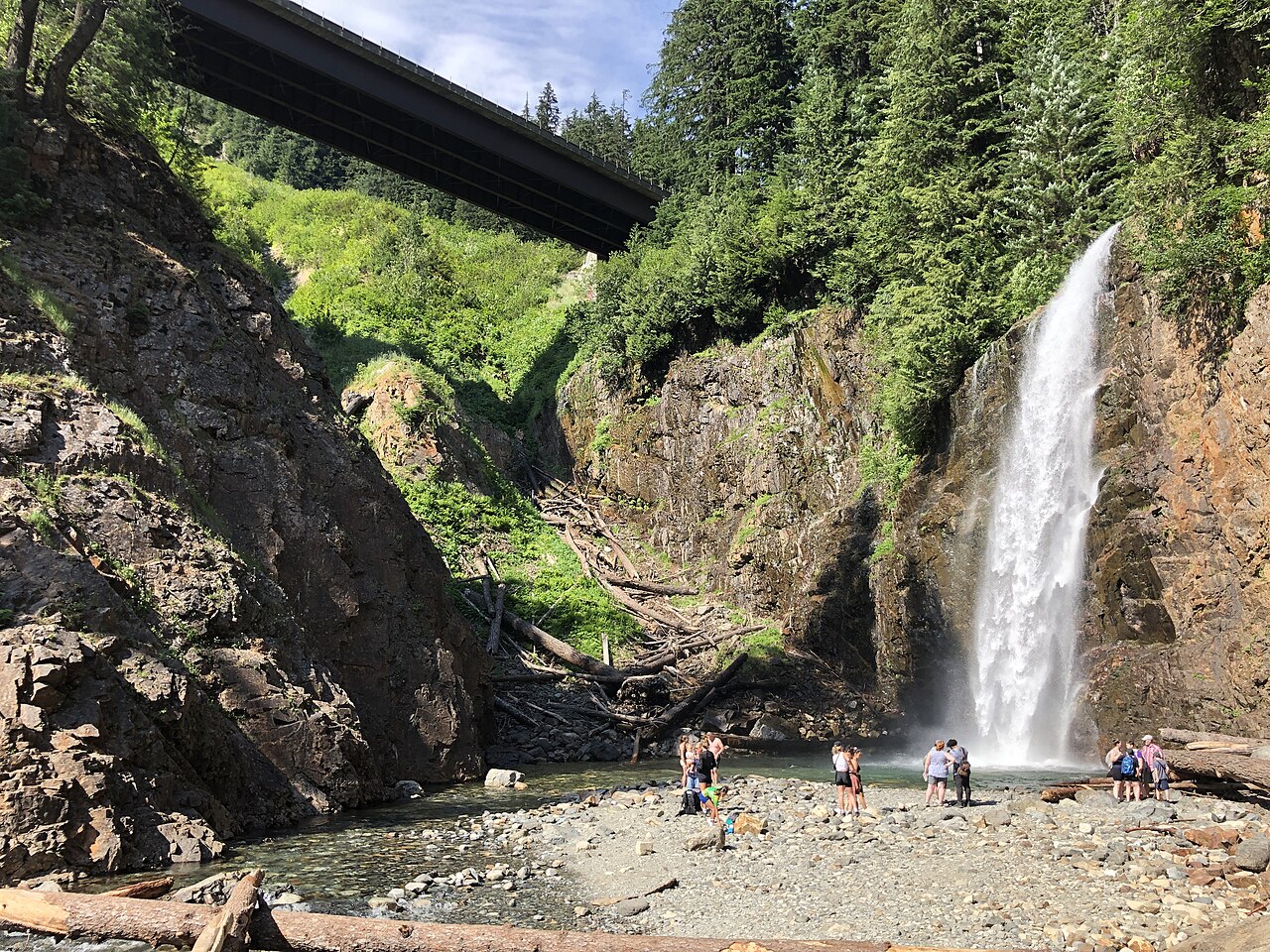
The southern gateway to the range, along Interstate 90 at Snoqualmie Pass, holds the two most hikeable waterfalls in this guide — and two of the busiest trails on the entire I-90 corridor. Franklin Falls is the family favorite. We list it at 135 feet on the South Fork Snoqualmie River within the Mount Baker-Snoqualmie National Forest; the Northwest Waterfall Survey describes a taller multi-tier formation of roughly 151 feet across three tiers, only part of which is visible from the base. The hike is the easy kind: about 2 miles round trip on Trail 1036 with roughly 400 feet of elevation gain, following the river up through dense conifer canopy to the splash zone at the base. It's reachable late spring through fall, and snowshoers visit it in winter when the road in is gated by snow. Note that the falls sit in an oddly modern spot — tucked between the eastbound and westbound lanes of I-90.
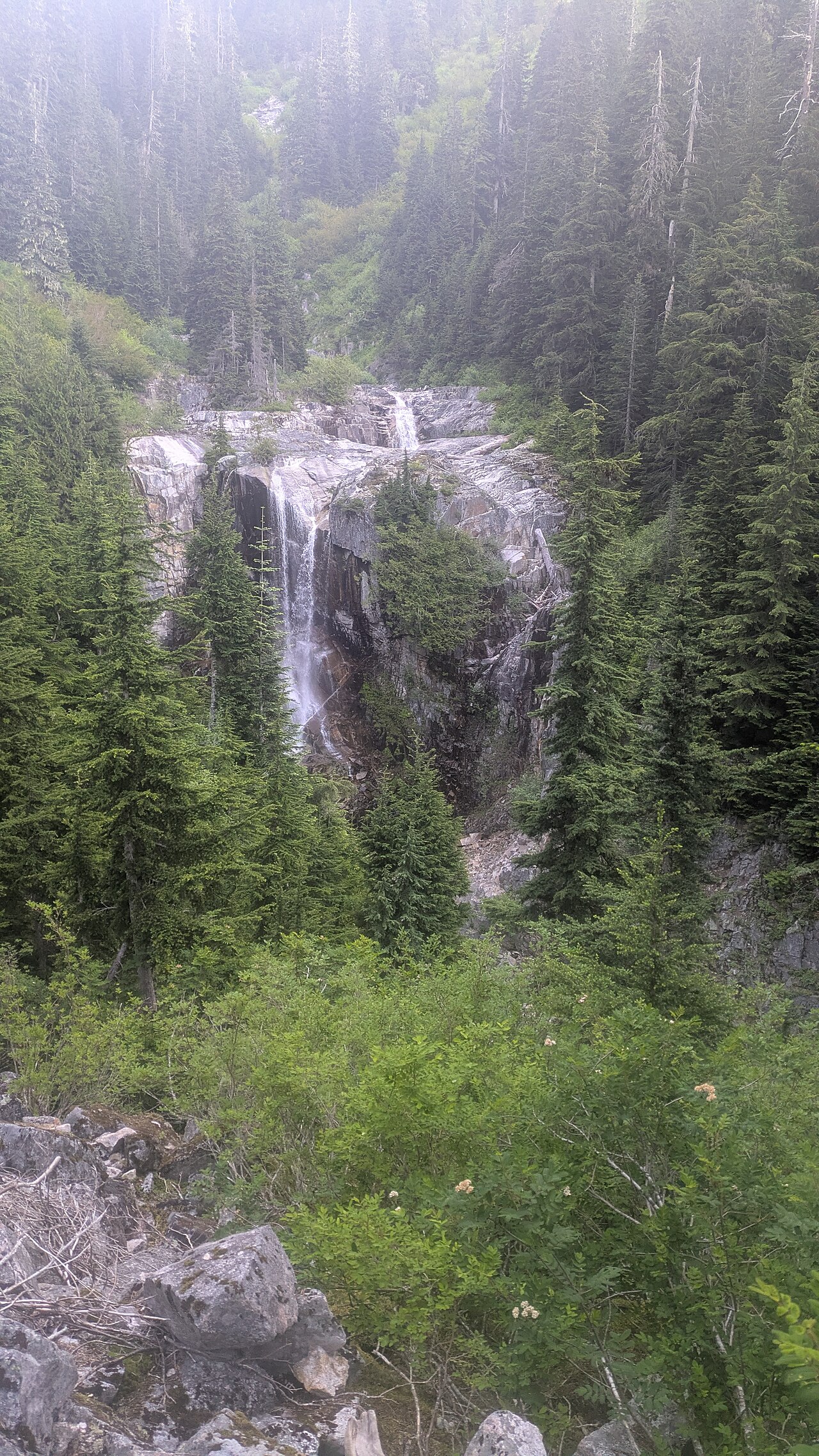
For a little more effort and a wilder feel, continue from the nearby Denny Creek trailhead to Keekwulee Falls. This one is on Denny Creek inside the Alpine Lakes Wilderness, and we track it at 125 feet — a two-drop falls of roughly 90 feet and 35 feet, which matches the combined figure cited by the Northwest Waterfall Survey and Wikipedia. The Denny Creek (Melakwa Lakes) Trail climbs at a moderate grade for roughly 1.8 miles to a boulder-field viewpoint looking down at the falls; round-trip distances are commonly quoted around 4 to 5 miles depending on where you turn around. Summer, after the snowmelt has receded, is the practical season. One real hazard: the trail fords Denny Creek without a bridge about a mile in, and when the creek runs high the crossing is genuinely dangerous — the rocks are slick and there's another waterfall just downstream of the ford. Don't force it in high water.
The name Keekwulee is worth a moment too. It was coined in 1916 by hikers from The Mountaineers, drawn from the Chinook Jargon word keekwulee — roughly, "to fall down" — which is about as fitting a name as a waterfall can get.
How to Rank and Plan a North Cascades Waterfall Trip
If you're ranking these five by sheer spectacle, Rainbow Falls wins on height and remoteness, Gorge Creek Falls wins on accessibility-to-drama ratio, and Nooksack Falls wins on raw power per foot of drop. For hiking, Franklin Falls is the easy crowd-pleaser and Keekwulee Falls is the one that makes you feel like you've earned the view. But the more useful way to plan is by region and season, because the North Cascades rarely let you string all of these together in a single loop.
Season is the master variable. Almost everything here peaks during the late-spring and early-summer snowmelt — think May into June for the lower-elevation falls, with the highest creeks running strong a little later. That's the trade-off at the heart of North Cascades waterfall touring: the falls are biggest exactly when high passes and roads may still be closed. Highway 20 governs access to the Gorge Creek and Stehekin tier and can open as late as June in heavy or repair-affected years; the Snoqualmie Pass falls along I-90 are reachable far earlier and more reliably; and the Mount Baker corridor sits in between.
A realistic itinerary treats these as separate trips rather than one circuit. A Snoqualmie Pass day handles Franklin Falls and Keekwulee Falls together off I-90. A Mount Baker day built around SR 542 makes Nooksack Falls its anchor. And the national-park core — Gorge Creek Falls from Highway 20, with Rainbow Falls as a committed boat-in add-on via the Lake Chelan ferry to Stehekin — is its own multi-day undertaking. Before any of it, check current road and trail conditions with the National Park Service, the Forest Service, and WSDOT, and check recent reports on Washington Trails Association or AllTrails for fords, washouts, and snow. In this range, last week's conditions are worth more than any guidebook — including this one.