Start by Clustering Falls, Not Chasing Them
The single biggest mistake on a waterfall trip is treating each fall as a standalone destination and driving hours between them. The falls that reward a road trip are the ones that come in clusters, where a single base town puts several within an easy radius. Hawaii's Kauai is the clearest example: Wailua Falls, a 173-foot segmented drop on the South Fork of the Wailua River, and ʻŌpaekaʻa Falls, a 151-foot plunge on ʻŌpaekaʻa Stream, both sit a short drive inland from the east-shore towns of Līhuʻe and Kapaʻa. Both are roadside overlooks with no real hike required, which means you can see two named falls in a single morning and still have the afternoon for the beach.
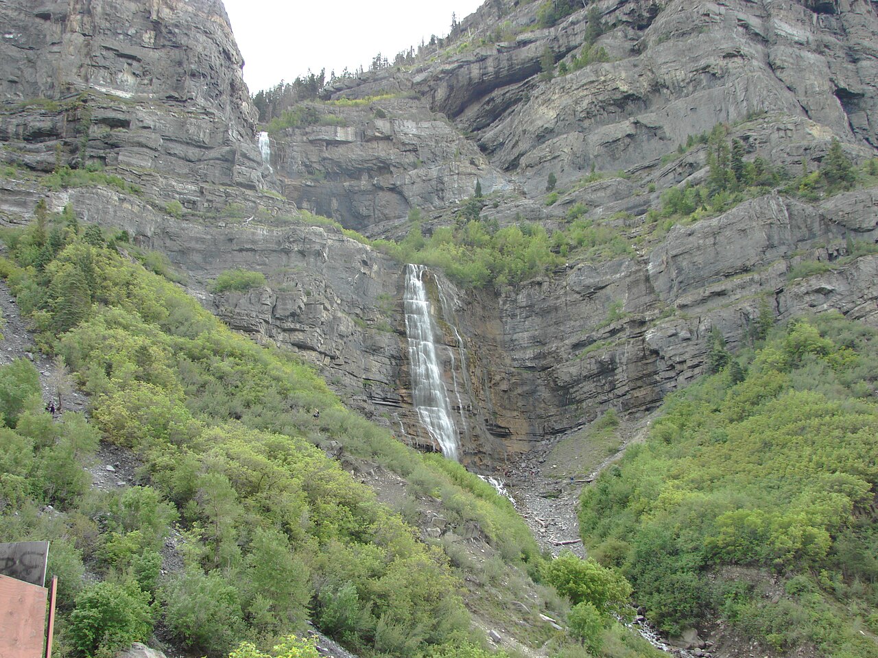
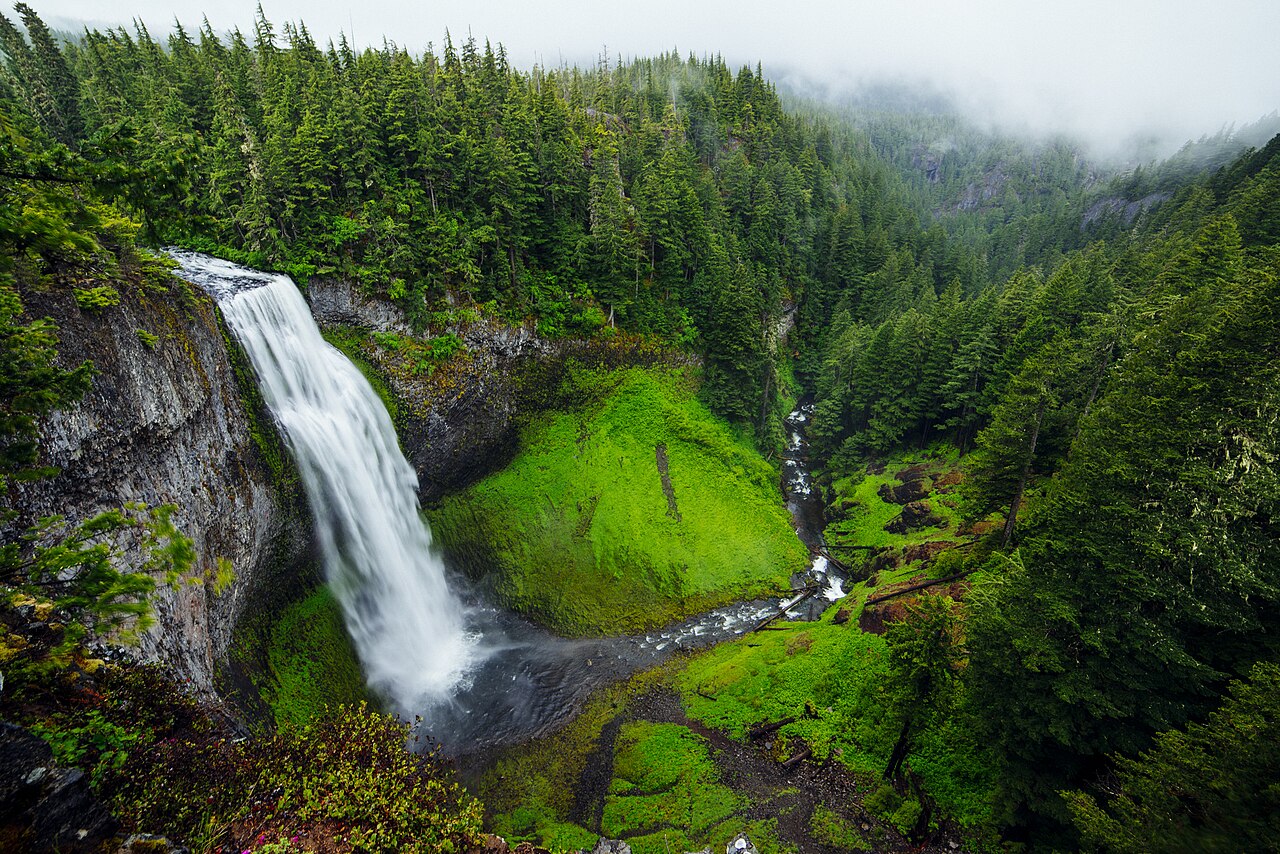
Build your route around a hub-and-spoke pattern. Pick a town with lodging and food, then list every named fall within roughly an hour's drive. The example stops in this guide each anchor a usable hub: Provo, Utah for Bridal Veil Falls; Oakridge, Oregon for Salt Creek Falls; Twin Falls, Idaho for Shoshone Falls; and West Glacier, Montana for Bird Woman Falls. Sketch the spokes, then sequence them so you're not backtracking across the same mountain pass twice.
Reported heights are a useful clustering signal but a treacherous bragging point. The figures you see vary by source and by what they measure: a single sheer drop versus the cumulative height of a multi-tier cascade. Bridal Veil Falls in Utah is commonly listed around 607 feet as a tiered fall, but that number reflects the full staircase, not one continuous plunge. Use heights to decide what's worth the detour, not to rank winners, and when in doubt, cross-check against the USGS Geographic Names Information System (GNIS) and the World Waterfall Database, which track the discrepancies rather than papering over them.
Check Seasonal Flow Before You Commit a Day
A waterfall is only as good as its water, and flow is overwhelmingly seasonal. Most of the West runs on snowmelt, which means the falls peak in a fairly narrow spring window and can dwindle to a trickle by late summer. Bridal Veil Falls (UT) peaks during spring snowmelt from roughly April through June. Salt Creek Falls (OR), a 286-foot plunge in the Willamette National Forest, hits its stride during late-spring melt in May and June. Grand Falls (AZ) on the Little Colorado River is a special case: this 185-foot tiered fall is muddy, dramatic, and entirely dependent on March-April snowmelt and runoff, so it can be bone-dry most of the year and roaring for only a few weeks.
Higher-elevation alpine falls melt out later and on the mountain's schedule, not the calendar's. Bird Woman Falls (MT), a 560-foot horsetail fall in Glacier National Park, is fed by a hanging valley that holds snow well into summer; its best viewing runs June through July, and it is only visible once Going-to-the-Sun Road has fully plowed and opened to its high point. In a cold, deep-snow year that opening slips later, so confirm road status before you build a day around it.
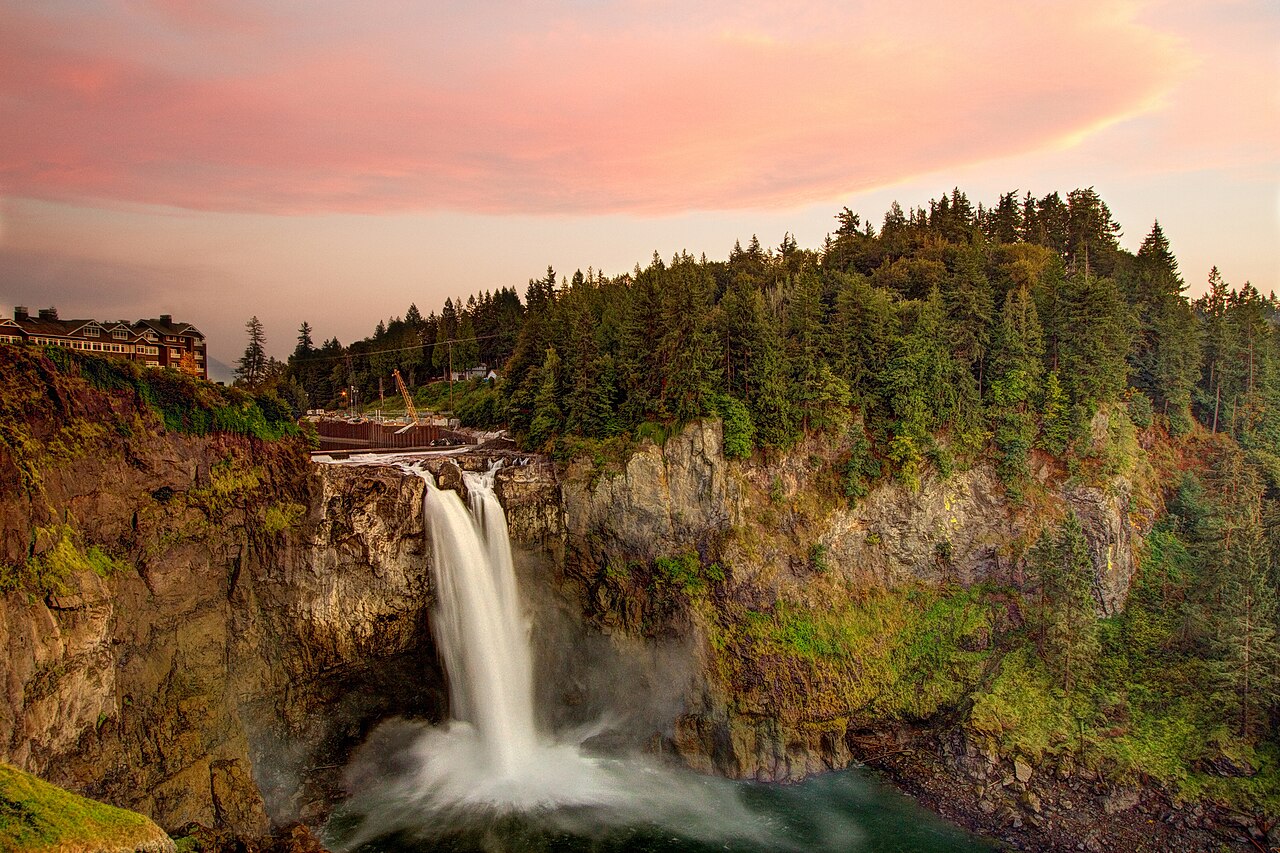
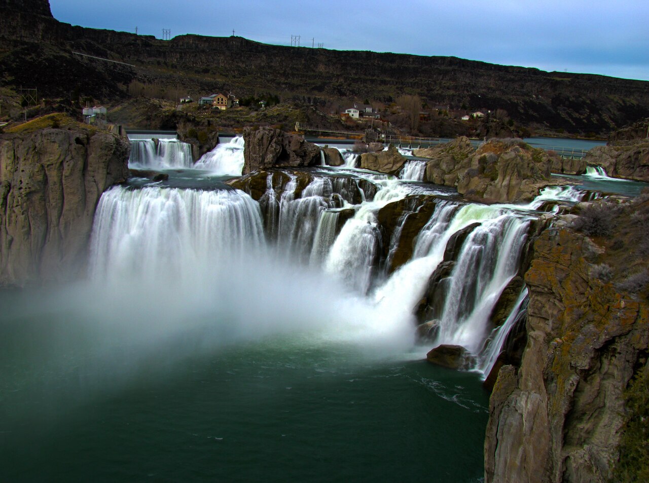
A handful of falls escape the snowmelt boom-and-bust. Snoqualmie Falls (WA), a 268-foot plunge on the Snoqualmie River, flows year-round and is at its most thunderous in the wet winter and spring months from November through May. Niagara Falls (NY) flows year-round with peak volume from late spring through summer; its flow is also actively managed, with more water diverted to hydropower at night and in the off-season under a long-standing treaty. Shoshone Falls (ID), the 212-foot 'Niagara of the West' on the Snake River, depends on both snowmelt and upstream reservoir and irrigation releases, which means flow can drop sharply by mid-to-late summer in a dry year. The lesson: for any Western river fall, check a current gauge or the managing agency's conditions page within a week of your trip rather than trusting a generic 'best season' label.

Sort Out Access, Permits, and Fees in Advance
Every fall sits on someone's land, and the rules follow the landowner. The featured stops here span national parks, national forests, a state park, tribal land, a city park, a private college campus, and a utility-run viewing park, and each has its own access regime. Sorting this out before you drive saves a wasted trip to a closed gate.
Federal land falls under agency rules. Bird Woman Falls is in Glacier National Park (NPS), which charges a park entrance fee; for 2026 the park is not requiring timed-entry vehicle reservations, a change from its 2025 pilot, but it manages crowds with temporary closures when lots fill and is piloting a ticketed shuttle to Logan Pass, so arriving early still matters. Salt Creek Falls in the Willamette National Forest (USFS) requires a day-use fee or interagency pass at the observation site in season; in winter the observation site closes and the access road requires an Oregon Sno-Park permit (November 1 to April 30), with a roughly 0.4-mile walk in from the Salt Creek Sno-Park to reach the view.
State, city, private, and tribal stops each have their own twist. Niagara Falls State Park (NY) is free to walk into, but charges seasonal parking, free midweek much of the year and rising on peak summer weekends. Shoshone Falls Park (ID), run by the City of Twin Falls, charges a per-vehicle fee in season (roughly March through September) and waives it in winter. Toccoa Falls (GA), a 186-foot plunge, sits on the private campus of Toccoa Falls College; you pay a small admission inside the Gate Cottage gift shop, and access tracks the shop's hours rather than dawn-to-dusk. The most important access note in this guide concerns Grand Falls (AZ): it lies on Navajo Nation land, requires a Navajo Nation backcountry permit when open, and has been subject to closures over trash, livestock harm, and disrespect of sacred ground. Treat it as closed until you confirm otherwise with the Navajo Nation Parks & Recreation office or the local Leupp Chapter, and never trespass on tribal land to reach a fall.
Time It for Light and Crowds
Once you know a fall has water and is open, timing within the day decides whether you get a photograph and a moment of quiet or a parking-lot scrum and a blown-out picture. The two levers are light and crowds, and they usually point the same direction: early.
Light depends on which way the fall faces and how deep its canyon is. Deep, narrow gorges like Shoshone Falls on the Snake River and the basalt amphitheater at Salt Creek Falls fall into shadow for much of the day and light up only when the sun clears the rim, so midmorning often beats both harsh noon and early dawn. Broad, open falls like Niagara photograph well in the soft light of early morning and the hour before sunset, and Niagara's daytime mist frequently throws rainbows when the sun is behind you. On a sunny day, the spray at Snoqualmie and Shoshone can produce its own rainbow if you position the sun at your back. For the silky, long-exposure look, you want overcast skies or shade, not direct sun, which is one more reason the shoulders of the day outperform noon.
Crowds are most beatable by hour. Roadside and short-hike falls are exactly the falls that fill with casual visitors, so the same accessibility that makes Wailua Falls, ʻŌpaekaʻa Falls, Snoqualmie Falls, and Bridal Veil Falls easy makes their small lots fill fast on weekends and holidays. Arrive within the first hour after opening or in the last hour of light, and favor weekdays. At fee parks that charge only on certain days, the pricing itself signals the crowd calendar: Niagara's free midweek parking and Shoshone's winter fee waiver both flag the quieter windows. In Glacier, where lots can close when full, an early start is the difference between driving the road and being turned back at the entrance.
What to Pack for a Falls-Focused Trip
Standing next to falling water is a wetter, slipperier business than the roadside overlook photos suggest, and the gear that matters is unglamorous. Even at a 0.1-mile paved viewpoint like Snoqualmie Falls or the Niagara overlooks, drifting mist soaks clothing and fogs lenses, and the railings and rock near any high-volume fall stay perpetually wet and slick. Footwear with real grip beats fashion every time; closed-toe shoes with a lugged sole handle wet stone and the short, often muddy approach paths at falls like Grand Falls (about a half mile over open ground) and the brief trail spurs at Salt Creek and Bridal Veil.
Bring a layer for spray and a layer for elevation. A light rain shell doubles as mist protection at the close-up viewpoints and as wind protection at alpine overlooks like Bird Woman Falls, where Going-to-the-Sun Road tops out cold and breezy even in July. Pack a microfiber cloth or two for wiping lenses and phone screens between the spray and the shot, and a dry bag or zip bag for electronics if you plan to get close. A refillable water bottle, sun protection, and a paper or offline map round out the kit, because cell coverage drops out fast on forest roads, on tribal land near Grand Falls, and along stretches of Going-to-the-Sun Road.
Finally, pack the things that keep these places open. Carry out every scrap of trash, stay on the established viewing areas and trails, and skip the climb over the railing for a better angle, the rocks above a waterfall lip are where serious accidents happen. The Grand Falls closures are a direct consequence of visitors who didn't, and the difference between a fall that stays accessible and one that gets gated is largely the behavior of the people standing at the overlook.