Why the Blue Ridge Is Waterfall Country
The Blue Ridge Parkway runs along the spine of the southern Appalachians from Shenandoah National Park in Virginia to Great Smoky Mountains National Park in North Carolina. The mountains here are old, steep, and exceptionally wet: orographic lifting wrings heavy rainfall and seasonal snowmelt out of moisture moving up from the Gulf and the Atlantic, and that water has to get back down. It does so over hard, resistant rock that erodes slowly, leaving the steep drops and ledges where waterfalls form. The result is one of the densest concentrations of falls anywhere east of the Rockies, and the Parkway is the convenient ribbon that ties them together.
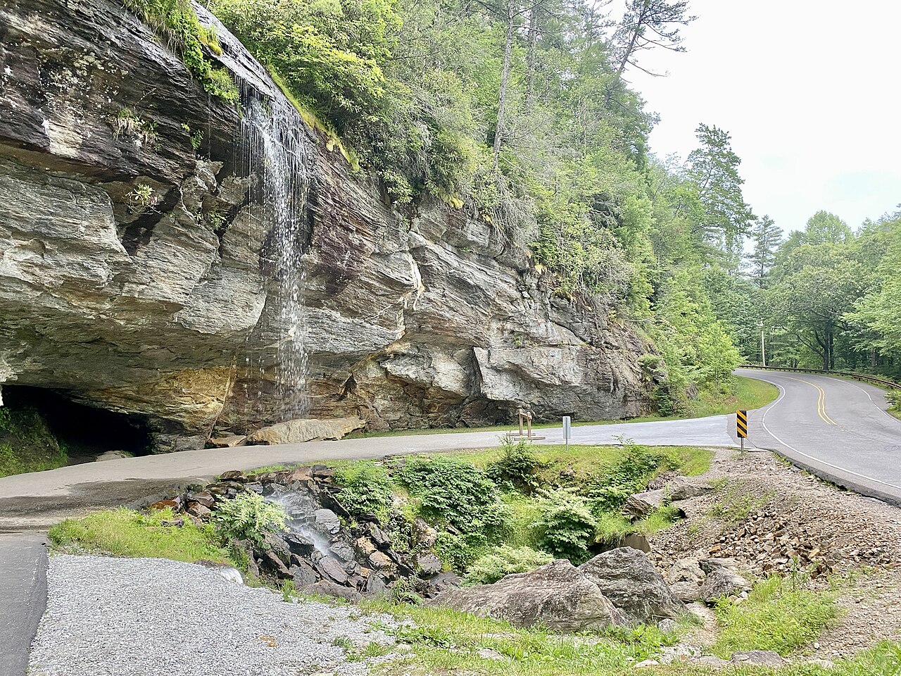
Crucially, almost none of these waterfalls actually fall onto the Parkway road itself. The Parkway is a scenic motor route, and its land managers (the National Park Service) administer only a narrow corridor and a handful of falls directly, most notably Linville Falls. The rest of the falls in this guide sit on adjacent public land: the George Washington and Jefferson National Forests in Virginia, the Nantahala and Pisgah National Forests in North Carolina, DuPont State Recreational Forest, North Carolina's Gorges State Park, and the Qualla Boundary of the Eastern Band of Cherokee Indians. The Parkway functions as the trunk; you exit at a milepost and drive a short connector to reach the trailhead.
Because this is a corridor rather than a single park, distances matter. Some falls in this guide, like Crabtree Falls and Apple Orchard Falls, are in the Virginia highlands a few miles off the northern Parkway. Others, like Whitewater Falls, Rainbow Falls, and the DuPont State Forest falls, are clustered in the southwestern North Carolina mountains near Cashiers, Sapphire, and Brevard, reachable from the Parkway's southern reaches. Plan by region, not by trying to see them all in a single day.
The Tallest Drops: Crabtree, Whitewater, and Cullasaja
If you rank these falls by reported height, the Virginia entry leads. Crabtree Falls on Crabtree Creek, in the George Washington National Forest near Montebello, Virginia, is frequently cited at around 1,000 feet of cumulative drop across a series of cascades and is often described as the highest vertical-drop cascade in the eastern United States. That figure is a cumulative number for a multi-step cascade rather than a single sheer plunge, which is the right way to read most Appalachian height claims. The trail to the upper viewpoint runs roughly 3.4 miles and is rated strenuous, climbing steadily alongside the creek; the lower falls are reachable far more easily. Spring snowmelt from April through June puts the most water over the rock.
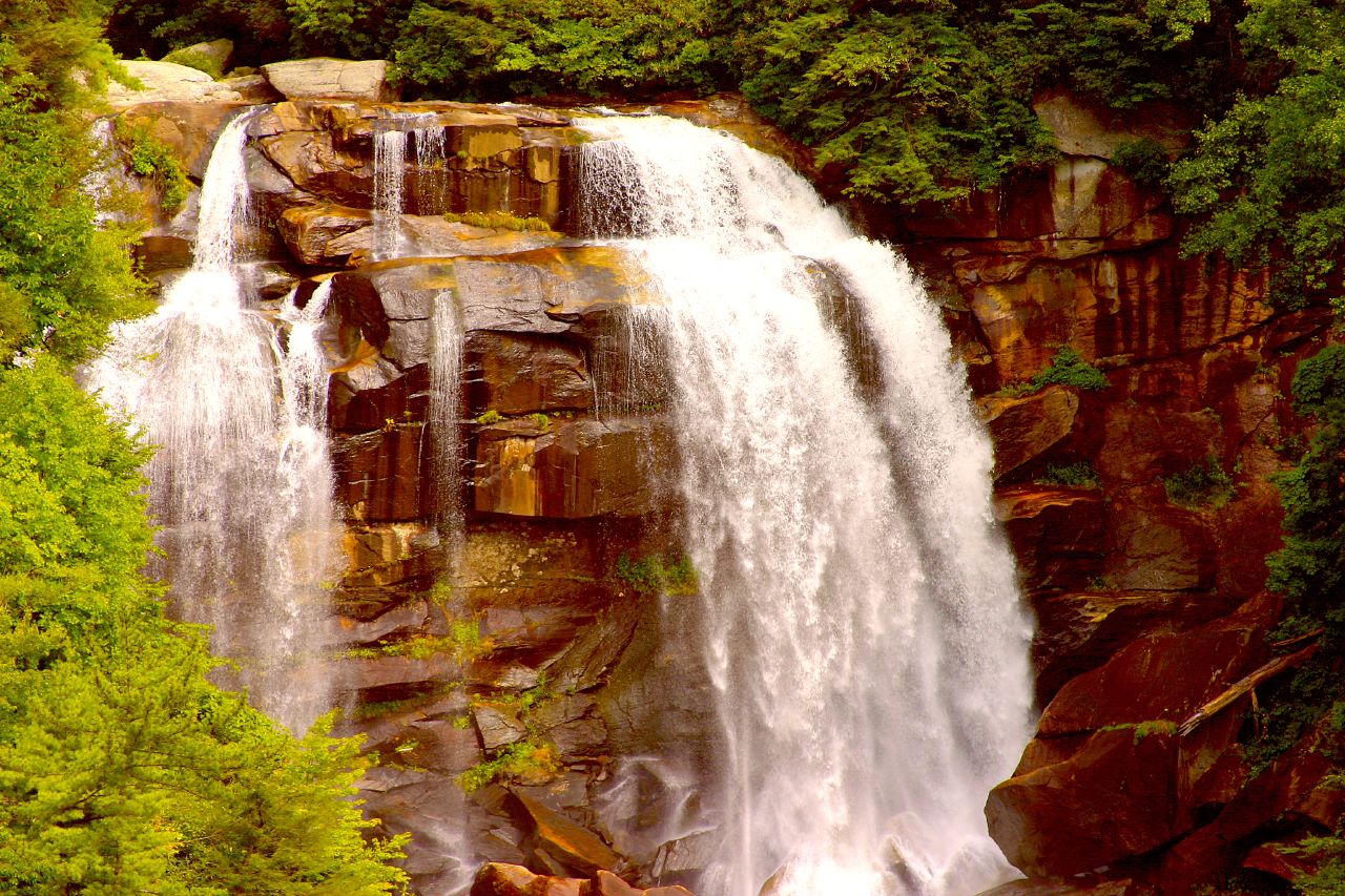
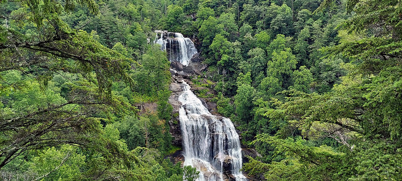
In North Carolina, Whitewater Falls on the Whitewater River near Sapphire is the marquee tall fall, reported at about 411 feet. It is described as one of the highest falls in the eastern United States, and unlike Crabtree it rewards almost no effort: a paved path of roughly 0.6 miles from the parking area leads to an upper overlook, making it an easy walk for most visitors. The river drops in tiers here, and the volume peaks with spring snowmelt and after heavy rain, generally March through May. Note that this guide's data also lists the upper portion of the system separately (under the slugs upper-whitewater-falls-nc and whitewater-falls-upper-nc), reflecting how different databases catalog the same complex of drops; treat the 411-foot figure as the headline number for the whole system rather than for any single ledge.
Cullasaja Falls rounds out the tall trio, reported around 200 feet on the Cullasaja River near Highlands, North Carolina, in the Nantahala National Forest. Cullasaja is the rare roadside giant: it tumbles in a long cascade right alongside US 64 through the Cullasaja Gorge, so there is effectively no hike, only a small and notoriously tight pull-off. The trade-off is that the viewing is from the road shoulder of a narrow, winding highway, so caution is essential. Because it is roadside, Cullasaja is one of the few falls here you can appreciate without committing to a trail.
The Parkway's Own Showpiece: Linville Falls
Of all the falls in this guide, Linville Falls is the one the Blue Ridge Parkway actually owns and operates. Administered by the National Park Service as part of the Parkway, it sits on the Linville River near the community of Linville Falls, North Carolina, and is reported at roughly 150 feet across its tiered drops. It is the most developed waterfall experience in the corridor, with a Parkway visitor center, well-maintained trails, and multiple overlooks that show the falls from different angles as the river pours into the rugged Linville Gorge below.
The trail network gives you options. A round trip of roughly 1.6 miles at moderate difficulty reaches the principal overlooks; shorter spurs reach the upper falls and the Chimney View, while a longer, steeper route descends toward the gorge and the plunge basin. Because the falls are fed by the Linville River draining a large highland watershed, they hold water better through dry spells than smaller creeks, but they are still at their most dramatic in spring and after heavy rain, roughly April through June.
Linville Falls is the logical anchor for a Parkway waterfall trip because you never leave the Parkway to reach it and the infrastructure is built for visitors. It pairs naturally with the surrounding Linville Gorge Wilderness for those who want to extend a day hike, and it is a sensible first stop before venturing onto the rougher, less-developed falls on adjacent national-forest and state-park land.
The DuPont Cluster: Triple, High, and Bridal Veil Falls
Near Brevard, North Carolina, DuPont State Recreational Forest holds a remarkable concentration of waterfalls on the Little River, three of which appear in this guide. They are close enough together that a single loop can string them up, and the forest's gravel roads and old carriage trails make the walking straightforward. This cluster is reachable from the Parkway's southern North Carolina section and is one of the highest-value stops for a half-day on foot.
Triple Falls, reported around 125 feet, is the namesake three-step tiered fall and the most efficient payoff: a trail of roughly 1.2 miles at moderate difficulty reaches viewpoints of all three drops, and a broad rock shelf between tiers is a popular spot to pause. High Falls, also on the Little River and reported around 150 feet, is the tallest of the DuPont three, a wide cascade reached by a trail of about 2 miles at moderate difficulty. Both are signature DuPont scenery and are often hiked together as part of one loop.
Bridal Veil Falls completes the set at about 120 feet, a sliding cascade over a long, gently angled rock face that the Little River fans out across. It sits farther into the forest, with the listed route running roughly 4.4 miles at moderate difficulty, so it asks more of your legs than its neighbors. Note that Bridal Veil is a common waterfall name in the region, and this DuPont fall on the Little River is distinct from same-named falls elsewhere in the southern Appalachians; the watercourse and forest are the way to keep them straight.

Gorges, Cherokee Country, and the Virginia Highlands
Southwest of the DuPont cluster, North Carolina's Gorges State Park near Sapphire protects the wild Horsepasture River, home to Rainbow Falls, reported around 150 feet. The trail runs roughly 3.1 miles at moderate difficulty and the falls earn their name: on sunny afternoons the spray throws rainbows across the gorge. The wet rock and cliff edges here are genuinely hazardous, and the river drainage is steep and remote, so it is a fall to respect rather than scramble around. Spring is the listed best season, when flow is highest.
On the Eastern Band of Cherokee Indians' Qualla Boundary near Cherokee, Mingo Falls is one of the most striking of the shorter hikes. Reported around 120 feet on Mingo Creek, it is reached by a trail of only about 0.4 miles, but that short distance climbs a steep staircase, which is why it rates as moderate rather than easy despite the distance. Nearby, Soco Falls is a roughly 120-foot segmented fall on Soco Creek near Maggie Valley, viewable from a short trail of about 0.6 miles off US 19; two streams drop side by side here, which is what gives it the segmented form. Both sit on or beside tribal land, so visitors should follow posted rules and treat the area with appropriate respect.
Back north in Virginia, the highlands near the Parkway hold two more worth the detour. Apple Orchard Falls, reported around 200 feet on Apple Orchard Falls Branch in the Jefferson National Forest near Buchanan, is reached by a trail of roughly 2.7 miles rated strenuous, with spring the best season. Statons Creek Falls, a roughly 140-foot cascade on Statons Creek near Vesuvius in the George Washington National Forest's Pedlar Ranger District, is essentially roadside with no maintained trail, making it an easy stop best caught in spring. Together with Crabtree Falls, these give the Virginia end of the Parkway its own compact waterfall circuit.
Reading Heights, Seasons, and Difficulty Honestly
A recurring theme in this guide is that reported waterfall heights vary by source and by method. A 1,000-foot figure for Crabtree Falls or a 411-foot figure for Whitewater describes the cumulative drop of a multi-step cascade, not a single sheer plunge, and different databases measure the start and end points of a fall differently. Some catalogs even split one waterfall complex into separately listed upper and lower sections, which is why the Whitewater system appears more than once in our data. Use these numbers to compare relative scale, not as surveyed precision, and expect the figure on a trail sign to differ from the one in a database.
Season is the single biggest factor in whether a fall impresses or disappoints. The strongest flows across the region come from spring snowmelt and rain, broadly March through June, with several of these falls explicitly listing spring as their best season. Creek-fed falls like Crabtree, Apple Orchard, and the DuPont and Gorges falls drop noticeably in late-summer dry spells, while larger-river falls like Linville and Whitewater hold up better. After a heavy rain is reliably the most dramatic time to visit almost any of them, and winter can add ice formations at the cost of snow-closed Parkway sections.
Difficulty in this guide blends trail distance with terrain, and the two do not always track. Mingo Falls is only about 0.4 miles yet rates moderate because of a steep staircase, while Whitewater Falls is an easy 0.6-mile paved walk to a far taller fall. Crabtree and Apple Orchard are strenuous because of sustained climbing, and Bridal Veil at DuPont is the longest listed route here at about 4.4 miles. Roadside falls like Cullasaja and Statons Creek demand the least walking but the most caution, since you are viewing from narrow highway shoulders. Match the hike to your group, carry water, and remember that wet rock at the brink of any of these falls is where the real danger lies.