Why Washington Is Waterfall Country
Washington's geography is a waterfall factory. Wet Pacific air slams into the Cascades and the Olympics, drops enormous amounts of rain and snow, and that water has to get back to Puget Sound and the Columbia somehow. The result is thousands of documented drops cataloged across USGS GNIS, the National Park Service, the U.S. Forest Service, and the Washington State Parks system — plus volunteer-driven inventories like the World Waterfall Database and the Northwest Waterfall Survey. No single guide can cover all of them, and this one does not try to. What follows is a curated set of five waterfalls chosen because they are well documented, reachable by ordinary visitors, and genuinely representative of the different kinds of waterfall the state produces.
A quick, honest note on numbers. Reported waterfall heights vary depending on who measured them and what they were measuring — the single tallest free-falling drop, the cumulative height of a multi-tier cascade, or a rough visual estimate from an overlook. You will see the same waterfall listed at different heights in different sources, and that is normal rather than an error. Where the figures we use diverge from other published numbers, we flag it. We have stuck to the documented values from land managers and waterfall databases rather than rounding up for effect.
The five waterfalls below span the state's geography on purpose: an alpine snowmelt giant on Mount Rainier, an urban-adjacent powerhouse half an hour from Seattle, a desert plunge in the Ice Age scablands of the southeast, a roadside drop on the way to Mount Baker, and an old-growth gem deep in the Olympic rainforest. Between them they cover the full range of Washington access — roadside, short stroll, and real hike — and the full range of seasonal timing.
Comet Falls — Mount Rainier's Tallest Roadside-Accessible Giant
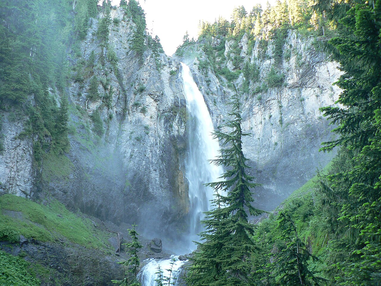
Comet Falls drops off Van Trump Creek in Mount Rainier National Park and is, by most published measures, the tallest waterfall reachable on a day hike at Rainier. The figure we use is a roughly 320-foot main plunge, which lands in the same neighborhood as the commonly cited cumulative heights — you will see numbers from about 300 feet for the principal free fall up to 400-plus feet when the smaller drops above and below are counted. The honest takeaway is that this is a several-hundred-foot ribbon of glacial meltwater, and the exact figure depends on where you start and stop the tape.
This is the most demanding waterfall on the list to reach. The trail runs roughly 3.6 to 3.8 miles round trip from the Comet Falls trailhead on the Nisqually-to-Paradise road, climbing steadily — on the order of 1,200 to 1,300 feet of gain — through forest and across Van Trump Creek. As a bonus, the route passes Christine Falls near the start, a tidy little drop framed by a stone highway bridge that is itself one of the most photographed spots in the park. Because the trailhead sits at elevation, the path holds snow well into the season; the practical window is summer, roughly July through September, once the snow has cleared and the meltwater is still running hard.
Plan it as a half-day outing rather than a quick stop. Mount Rainier National Park is managed by the National Park Service, which means an entrance fee and, in peak summer, a timed-entry reservation system you should check before you drive up. The payoff is an alpine waterfall fed directly by Rainier's snowfields, at its most dramatic exactly when the rest of the state's snowmelt-driven falls have already dwindled for the summer.
Snoqualmie Falls — The Big One You Can Drive To
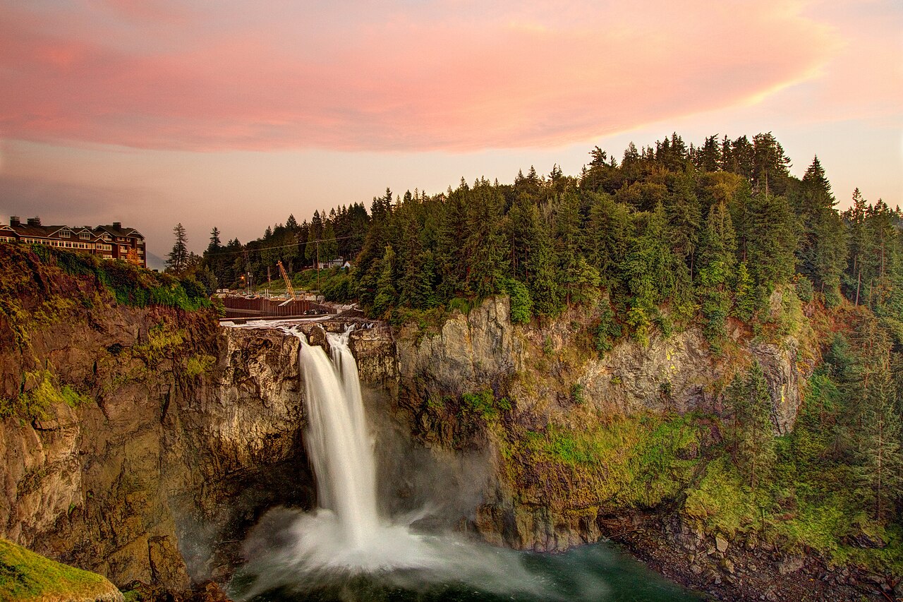
If you only see one waterfall in Washington, statistically it will be this one. Snoqualmie Falls plunges 268 feet on the Snoqualmie River about 30 miles east of Seattle, making it taller than Niagara and far more accessible than anything else on this list. The viewing area sits beside the town of Snoqualmie in a free, roughly 12-acre park, with the main overlook a flat hundred yards or so from the parking lot — genuinely roadside in the sense that matters. A half-mile trail connects the upper park to a lower, riverside boardwalk for an eye-level look, but you do not have to take it to see the falls.
The site is unusual in that it is privately owned and operated by Puget Sound Energy rather than a park agency. The falls feed PSE's oldest power-generating operation, the Snoqualmie Falls Hydroelectric Project, which dates to 1899 and was an early — and partly underground — hydropower plant. That heritage is part of why the overlook park exists at all and why it is free to visit; the interpretive kiosks on site lean into the engineering story alongside the scenery.
Snoqualmie runs year-round because the river behind it is large and rain-fed rather than dependent on a single season's snowmelt. The best viewing is generally the wetter months — roughly November through May — when high flow turns the plunge into a roaring, mist-throwing wall of water. In late summer the flow drops and a portion can be diverted for power generation, so the falls are at their leanest. Go on a gray, rainy winter weekday and you will both beat the crowds and catch it at full force.
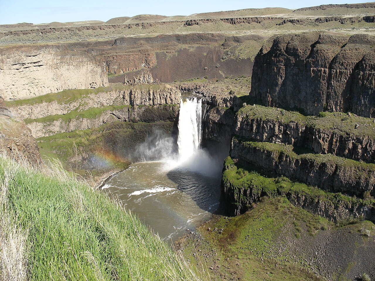
Palouse Falls — A Desert Plunge in the Ice Age Scablands
Palouse Falls is the outlier on this list and arguably the most spectacular setting. Out in the dry southeast corner of the state near Washtucna, the Palouse River drops about 198 feet in a single plunge into a vast bowl of columnar basalt — a sheer, amphitheater canyon that runs hundreds of feet deep. It is so distinctive that in 2014 it was designated Washington's official state waterfall, the result of a campaign led by schoolchildren from nearby Washtucna. You will occasionally see it rounded to 200 feet; we use the more commonly cited 198-foot figure, but as always the precise number depends on the measurement.
The geology is the real story here. Palouse Falls sits within the channeled scablands, the dramatic landscape gouged out by the Missoula floods — a series of cataclysmic Ice Age outbursts that repeatedly tore across eastern Washington more than 13,000 years ago. The falls are one of the last active remnants of that flood path, a few miles upstream of where the Palouse River meets the Snake. Standing at the overlook, you are looking at a single surviving waterfall on a channel that once carried a wall of water unimaginably larger than today's modest desert river.
Access is easy: Palouse Falls State Park is run by Washington State Parks, and the main overlook is a short walk — on the order of a few hundred feet — from the parking area, with additional viewpoints along the rim. A Discover Pass is required to park. Because this is a high-desert river rather than a snowmelt or rainforest stream, timing matters more than at the wetter sites. The falls are at their thunderous best during spring snowmelt, roughly April through June; by late summer the Palouse River can slow to a comparative trickle, and the canyon — not the water — becomes the main attraction. Note that scrambling down toward the base is dangerous and discouraged; the rim viewpoints are the safe and intended way to see it.
Nooksack and Sol Duc — Two Easy Falls Worth the Detour
Not every great waterfall is a giant. Nooksack Falls, on the North Fork Nooksack River near Glacier, drops about 88 feet — a height that has been confirmed by both field surveys and high-resolution lidar, so it is one of the more precisely documented numbers on this list. The river splits into segments and plunges into a narrow rock gorge, and it sits in the Mount Baker-Snoqualmie National Forest just a short distance off the Mount Baker Highway (State Route 542). The viewpoint is effectively roadside, reached by a short spur, which makes it an easy add-on for anyone heading up toward the Mount Baker area. Like Palouse, it peaks with spring snowmelt, roughly April through June. The gorge railings exist for a reason — the rock is slick and the drop is sheer, so this is a look-don't-climb stop.
Sol Duc Falls is the quietest pick here and, for many visitors, the most charming. Tucked into the Sol Duc Valley of Olympic National Park near Forks, it is a modest segmented drop of roughly 48 to 50 feet, but its character comes from its shape: the Sol Duc River makes a sharp bend and splits into several adjacent prongs that pour into a slot canyon, with a wooden footbridge crossing right at the brink for a dramatic overhead view. The setting is classic Olympic rainforest — moss, ferns, and old-growth conifers the whole way.
Reaching it is an easy 1.6-mile round-trip walk through the forest from the trailhead at the end of the Sol Duc Road, making it one of the most rewarding short hikes in the park. As an Olympic National Park site managed by the National Park Service, it carries an entrance fee, and the access road typically closes seasonally with snow. Because the Olympics get both heavy snowmelt and a long rainy season, Sol Duc runs well across two windows — spring melt from about April through June, and the wet late-fall-into-winter stretch from roughly November through January. Pair it with the nearby Sol Duc Hot Springs and it is an easy half day.
How to Use This Guide and Where to Go Deeper
Treat these five as anchors, not a complete list. They were chosen to be reliable, well documented, and spread across the state's regions and access levels, but Washington has thousands more drops — many on Forest Service land in the Cascades, others on the Olympic Peninsula, and a scattering in the scablands. If you want to go deeper, the volunteer-maintained Northwest Waterfall Survey and the broader World Waterfall Database are the most thorough inventories, while USGS GNIS is the authoritative source for official names and coordinates.
Two practical rules cover almost every Washington waterfall trip. First, match the waterfall to the season: snowmelt-driven falls like Palouse, Nooksack, and Comet are loudest in spring and early summer, the big rain-fed Snoqualmie peaks in the wet winter months, and Sol Duc straddles both. Second, check the land manager before you go, because the rules differ — National Park Service sites (Comet, Sol Duc) charge entrance fees and may require reservations, Washington State Parks (Palouse) needs a Discover Pass, Forest Service sites (Nooksack) often need a recreation pass, and Snoqualmie's privately operated park is free.
Finally, a safety note that applies everywhere here: waterfall viewpoints are railed and signed for a reason. The wet rock above and below a falls is far more slippery than it looks, and every year people get hurt leaving the marked overlooks at exactly these kinds of sites. The documented viewpoints give you the best photographs anyway. Stay on them, and you will see Washington's waterfalls the way the people who mapped them intended.