Mississippi waterfall country, honestly explained
Mississippi is a low, flat, sediment-built state, and that geology mostly works against waterfalls. There are no granite gorges and no mountain snowmelt to feed reliable year-round torrents. What the state does have are a handful of places where a creek meets a harder rock ledge — sandstone in the northeast, loess bluffs and limestone formations near the Mississippi River — and drops far enough to count. Add a few engineered or spring-fed exceptions, and you get a genuinely interesting, if modest, set of falls.
This is a curated selection, not a census. Some sources catalog dozens of named and unnamed cascades in Mississippi, and Clark Creek Natural Area alone is reported to hold roughly 50 of them. What follows are nine documented waterfalls that are worth planning a trip around, ordered roughly from the easiest and most rewarding to the most obscure and demanding. We've leaned on the World Waterfall Database, the National Park Service, the U.S. Forest Service, the Mississippi Department of Wildlife, Fisheries, and Parks (MDWFP), and trail records from AllTrails to keep the facts honest.
One caveat worth stating up front: reported heights for Mississippi waterfalls vary a lot by source and by how they're measured. A single clean drop and a long stair-step cascade get described very differently, and the same fall can appear as 25 feet in one record and 40 in another. Where we cite a height, treat it as an approximation rather than a surveyed figure, and don't be surprised if the number on a trailhead sign disagrees with the one in a guidebook.
The other thing to internalize is seasonality. Most of these falls are rain-fed and run hardest in late winter and spring. Visit in August after a dry spell and several of them will be a trickle, a damp ledge, or nothing at all. The major exceptions — the spring-fed and engineered falls — are flagged below.
The easy wins: Dunn's Falls and Owens Creek
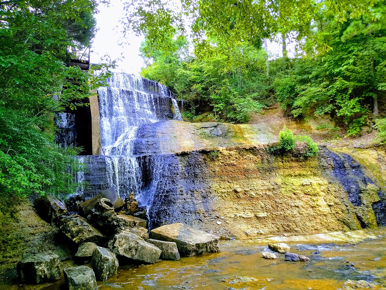
If you want the most waterfall for the least effort, start with Dunn's Falls, outside Enterprise near Meridian, inside a small park run by the Pat Harrison Waterway District. At roughly 65 feet it is one of the tallest falls you can stand in front of in Mississippi, and the setting is unusual: the water spills past a reconstructed 19th-century grist mill, originally part of the operation Irish immigrant John Dunn built here in the mid-1800s. The walk down to the falls is short — on the order of 0.4 miles and rated easy — and because the flow is spring-fed rather than purely rain-dependent, this is one of the few falls on the list that holds up reasonably well year-round.
Dunn's Falls is the rare Mississippi waterfall that's worth the trip regardless of season, and the gristmill, picnic area, and access to the Chunky River make it a half-day destination rather than a quick photo stop. There's a small admission fee, and it's managed as a day-use water park, so check current hours before you go.
For a near-zero-effort stop with a big asterisk, point your car at Owens Creek Waterfall on the Natchez Trace Parkway. It sits at milepost 52.4 in the Rocky Springs area near Hermanville, a short, easy walk from the parking pullout, and doubles as the southern terminus of the Rocky Springs section of the Natchez Trace National Scenic Trail. The asterisk is significant: the spring that once fed Owens Creek has largely dried up as the local water table dropped, so the fall now flows only after heavy rain. Time it right — winter or spring, ideally within a day or two of a good storm — and you'll get water over the stone ledge. Time it wrong and you'll get a dry rock shelf and a nice walk in the woods.
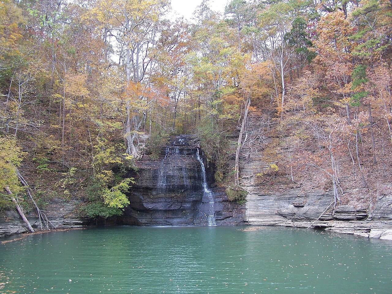
The big payoff: Clark Creek's ravine of waterfalls
If you only make one dedicated waterfall trip in Mississippi, make it Clark Creek Natural Area, roughly 13 miles west of Woodville in the far southwest corner of the state, almost on the Louisiana line. Managed by MDWFP, this 700-acre preserve sits in steep loess and gravel bluffs and is reported to contain on the order of 50 waterfalls, several with drops of about 30 feet — extraordinary density for a state this flat. The marquee cascade we feature here, Clark Creek Falls, is the kind of payoff that makes the whole region's reputation.
Reaching the best falls is real work, and the data backs that up. The primitive trail runs about 2.6 miles and is rated strenuous, typically taking three to five hours, with hilly terrain, washouts, slick clay inclines, fallen trees, and repeated creek crossings. There's also a shorter, easier improved trail of roughly 1.75 miles that gives a gentler sample, but the primitive loop is where the waterfalls cluster. Wear shoes you don't mind soaking, expect to use your hands on the steeper pitches, and carry far more water than feels necessary.
Season matters here as much as anywhere. Clark Creek runs best in winter and spring, especially after rain — which is also when the trail is muddiest and the crossings deepest, so there's an inherent trade-off between flow and footing. Summer visits can be hot, buggy, and underwhelming on water. Go in the cooler, wetter months, start early, and budget the better part of a day.
Northeast Mississippi: Bear Creek and Cooper Falls
The northeastern corner of the state, in the Appalachian foothills, has the rockiest terrain in Mississippi, and it shows. Tishomingo State Park, near the town of Tishomingo, is built around Bear Creek Canyon and its sandstone outcroppings, and the Bear Creek waterfall is a friendly, beginner-appropriate target. The popular Bear Creek Outcroppings route runs about 1.9 miles and is rated easy, winding past sandstone bluffs, spring-fed streams, and a swinging pedestrian bridge before reaching a modest fall (commonly described as roughly 8 feet) on Bear Creek. It's short in stature but high in atmosphere, and it runs best from late winter into spring after rain.
A short drive north, near Iuka and Pickwick Lake, is Cooper Falls — and this one comes with an access twist. The fall sits on Cooper Creek where it meets Pickwick Lake, on land associated with the Tennessee Valley Authority and MDWFP near J.P. Coleman State Park, and it is most easily reached by boat from the lake rather than by a maintained trail. That puts it in the backcountry category for anyone without a watercraft. Heights for Cooper Falls are reported inconsistently — our data lists about 40 feet while some tourism sources call it closer to 50 — another reminder to treat the number loosely.
Cooper Falls runs best in winter and spring, and because the base sits right at lake level, the pool below it doubles as a swimming and exploring spot for boaters in warmer months. Just be realistic about logistics: without a boat, this is a look-but-hard-to-touch destination, and conditions on Pickwick Lake should factor into your plans.
For the completist: Mint Spring Bayou, Rawson Gully, Brushy Creek, and Rocky Falls
A few Mississippi falls are more interesting as documented features than as easy outings, and these round out the guide for the genuinely curious. Mint Spring Bayou Falls sits inside Vicksburg National Military Park, a roughly 30-foot cascade (some records put the formation drop closer to 33 feet) on a bayou that supplied water to both armies during the 1863 Siege of Vicksburg and is wrapped up in local mint-julep lore. It's historically remarkable, but treat access with caution: the route is steep, unstable, and overgrown, it's been effectively closed to casual visitors for years, and it's best appreciated as a piece of park history rather than a hike you should improvise.
Rawson Gully Falls, just outside Meridian in Lauderdale County, is the opposite kind of place — almost roadside. Our data lists it around 25 feet, though some sources call it taller, and the catch is the setting: it's reached by a very short scramble from a dirt pullout off Russell Mountain–Gilead Road, but the ravine is steep and the approach has reportedly been used as an informal dump. It runs after winter and spring rain, makes for a quick stop if you're already near Meridian, and rewards low expectations more than a special pilgrimage.
On the demanding end is Brushy Creek Waterfall, deep in the Homochitto National Forest near Crosby, on U.S. Forest Service land. The route is long — roughly 10.7 miles out-and-back — and although it's often rated 'moderate' on grade, in practice it's considered one of the harder hikes in the state because the trail is essentially unmaintained, with downed trees, creek crossings, and easy-to-lose tread. It flows best in spring. Go prepared for navigation and self-rescue, ideally with a partner, GPS, and no expectation of cell service.
Finally, Rocky Falls near Hermanville is the kind of small, lightly documented cascade — listed around 5 feet — that exists more in databases and local memory than in trail guides. We include it for completeness and to be honest about the long tail of Mississippi waterfalls: many are tiny, seasonal, and obscure, with sparse public information on access and land ownership. If you chase the small ones, verify access and ownership locally before you go, and respect private property.
How to plan a Mississippi waterfall trip
Timing is the single biggest lever. With the exception of spring-fed Dunn's Falls, plan around late winter and spring, and ideally within a day or two of meaningful rain. The same storms that bring the falls to life also make trails slick and creek crossings deeper, so there's a built-in trade-off between dramatic flow and easy footing. Summer is the weakest window: low water, high heat, and biting insects.
Match the destination to your appetite for effort. For roadside and short, easy walks, choose Dunn's Falls, Owens Creek (after rain), Rawson Gully, and the Bear Creek loop. For a strenuous but high-reward day, choose Clark Creek's primitive trail. For genuine backcountry or boat-access objectives, look to Cooper Falls and Brushy Creek — and treat Mint Spring Bayou as a historical curiosity to view responsibly rather than scramble into.
Whatever you pick, verify current conditions and access before you drive. Land management here spans MDWFP state parks, the National Park Service (Natchez Trace Parkway and Vicksburg), the U.S. Forest Service (Homochitto), TVA-associated lands, and a local waterway district, each with its own rules, fees, hours, and seasonal closures. Carry more water than you think you need, wear shoes you're willing to soak, tell someone your plan on the longer routes, and remember that reported heights and trail numbers are approximations — let the actual creek, weather, and trailhead signage have the final word.