How to use this guide
Colorado has hundreds of named waterfalls scattered across its national forests, state parks, and high-country wilderness, and far more that never made it onto a map. This is not a complete inventory. It is a curated set of five well-documented falls drawn from public records — USGS GNIS place data, U.S. Forest Service and BLM recreation pages, state-park information, and waterfall databases — chosen because they are notable in height or character, reasonable to reach, and reliably worth visiting. Think of it as a starting itinerary rather than an encyclopedia.
The five are spread across the state, so you are unlikely to see all of them in one trip without serious driving. Bridal Veil Falls sits above Telluride in the southwest San Juans. Fish Creek Falls is just outside Steamboat Springs in the northwest. Seven Falls and Zapata Falls anchor the south and south-central regions near Colorado Springs and the Great Sand Dunes. Rifle Falls is a short detour off Interstate 70 in the northwest. Pick by region and pair each with the towns and parks nearby.
One honest caveat about the numbers you will see below. Reported waterfall heights vary by source and by how the measurement is taken — a single clean plunge versus the cumulative drop of a multi-tiered cascade. The figures here come from the documented data we work from, but treat them as solid approximations rather than surveyed precision. Where a fall is a series of drops, the height is the sum, not any one ledge.
Timing matters more in Colorado than in almost any other state, because most of these falls are snowmelt-driven. The same waterfall that thunders in late May can slow to a trickle by August. Each entry notes the best documented season, and the general rule holds across the board: late spring into early summer, roughly May through June, is peak flow.
Bridal Veil Falls — Colorado's tallest free-falling waterfall, near Telluride
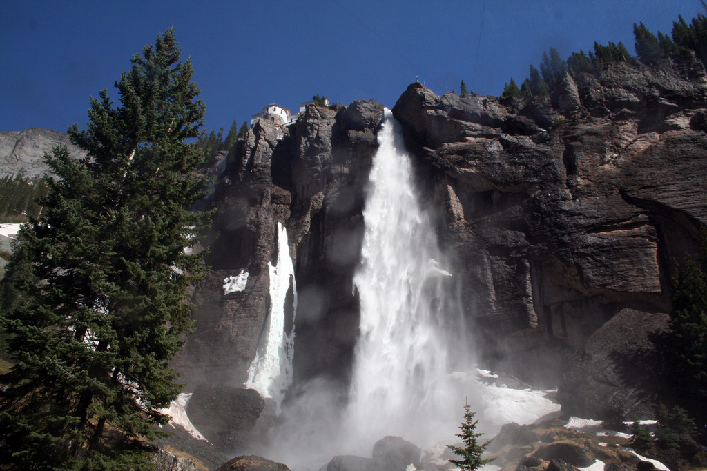
At a documented 365 feet, Bridal Veil Falls above Telluride is the tallest free-falling waterfall in Colorado. It is a single dramatic plunge of Bridal Veil Creek off the headwall at the end of a box canyon, and it is unmistakable: a historic hydroelectric power plant — the Smuggler-Union plant, built in 1907 — perches at the very lip of the falls, one of the most recognizable images in the state. The plant still generates power, which is part of why the structure remains.
The setting is the Uncompahgre National Forest area, though the falls and the powerhouse sit on private land held by the Idarado Mining Company, a legacy of the region's mining history. That mixed land status is worth knowing because access and the road above are managed accordingly. The hike to the falls runs roughly 3.6 miles round trip along a steep four-wheel-drive road that switchbacks up the canyon wall — a moderate effort with significant elevation gain, rewarded by views back down the canyon to Telluride.
Plan for late spring to early summer snowmelt, roughly May into June, when the San Juan snowpack is feeding the creek and the plunge is at full volume. Telluride sits at high elevation, so the road and upper trail hold snow later than lower-elevation falls; check conditions before committing. In deep winter the falls freeze solid and become one of the region's premier ice climbs, but that is a different and far more technical outing than the summer hike.
Fish Creek Falls — a short walk to a 283-foot plunge near Steamboat
Fish Creek Falls, about five miles east of Steamboat Springs in the Routt National Forest, is the easiest big waterfall on this list to reach and one of the tallest. The documented height is 283 feet — figures published elsewhere range from roughly 280 to 284 depending on the source and method, the kind of variation common to tall plunges — making it second in height on this guide only to Bridal Veil. It is a genuine plunge dropping into a glacier-carved canyon, managed by the U.S. Forest Service.
The payoff-to-effort ratio is what makes Fish Creek special. A short gravel path of roughly half a mile leads to a viewing area with a clean look at the falls and a footbridge near the base, so families and casual visitors get a dramatic waterfall without a strenuous climb. More ambitious hikers can continue on the longer trail that climbs the canyon toward Upper Fish Creek Falls and Long Lake, deeper into the national forest, but the lower viewpoint is the main event for most people.
Spring snowmelt, May into June, is when Fish Creek roars — the canyon fills with the sound of it and spray drifts across the lower trail. Because the trailhead is so close to Steamboat Springs and the walk is short, this is the most accessible introduction to a major Colorado waterfall, well suited to a half-day outing combined with the town.
Seven Falls and Rifle Falls — character over height
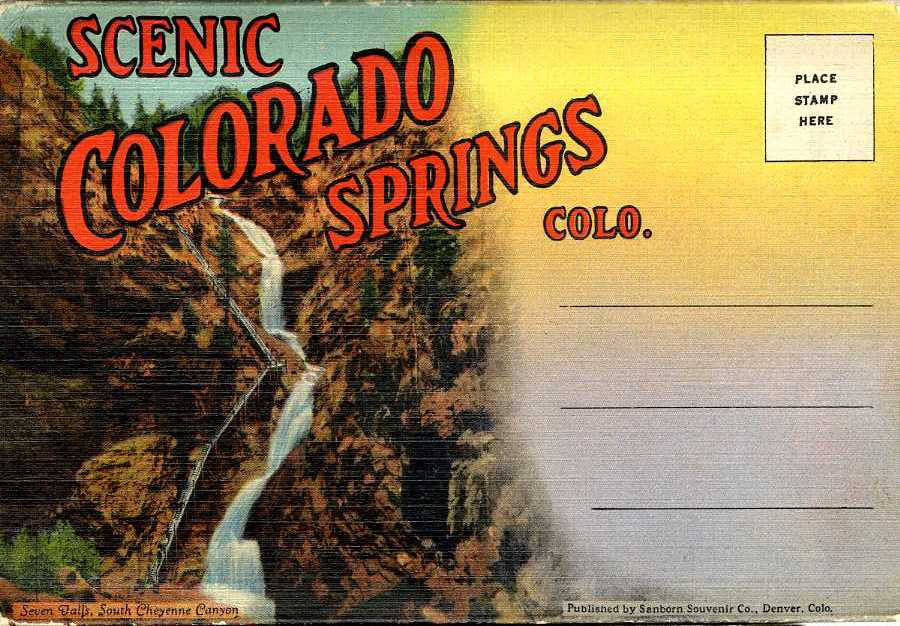
Not every memorable waterfall is the tallest one, and these two earn their place on character. Seven Falls, in South Cheyenne Cañon near Colorado Springs, is a tiered cascade of South Cheyenne Creek — seven distinct drops whose heights sum to about 181 feet, threading down a steep granite canyon roughly a thousand feet deep. The falls are a commercial attraction operated by The Broadmoor on private land, reached by a short approach of about 1.2 miles, with a long staircase climbing alongside the cascade and an elevator to an observation platform for those who would rather not take the stairs. Because it is privately managed, expect an admission fee and set hours rather than open national-forest access.
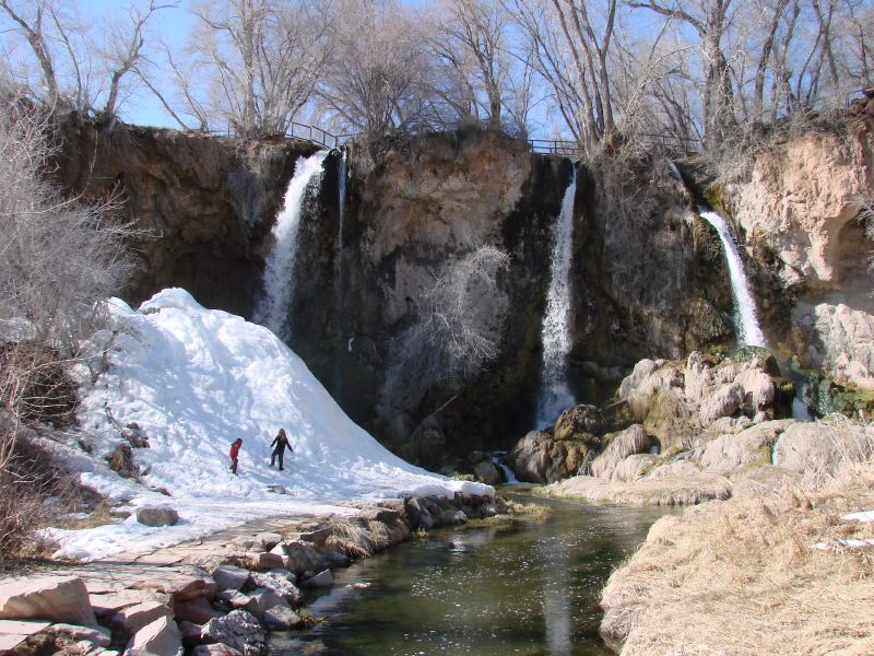
Rifle Falls, by contrast, is a state park you can walk into. The centerpiece of Rifle Falls State Park, run by Colorado Parks and Wildlife, is a segmented triple waterfall dropping about 70 feet over a travertine dam on East Rifle Creek. It is unusual in form: the three side-by-side curtains exist because a hydroelectric plant — one of Colorado's first, operating from 1908 to 1959 — altered the creek's flow and split what was once a single fall into three. Limestone caves tucked beneath and beside the falls add to the appeal and are accessible to visitors with a flashlight.
Both reward a short walk of roughly half a mile or so and both peak in spring to early summer, May into June, with the snowmelt. They make the case that height is only one measure of a waterfall worth visiting — a lush travertine triple-fall with cave passages and a tightly tiered granite-canyon cascade each offer something the tall single plunges do not.
Zapata Falls — a hidden punchbowl in the Sangre de Cristos
Zapata Falls is the smallest fall on this list at a documented 30 feet, but it is arguably the most distinctive. South Zapata Creek has carved a narrow slot through the crystalline rock of the Sangre de Cristo Mountains, and the waterfall — a punchbowl — tumbles inside a cave-like chasm that stays hidden from view until you are nearly on top of it. Reaching it means a short hike of about a mile and then a wade up the creek itself into the cold, slick gorge, which is part of the experience and part of the hazard.
The falls sit on Bureau of Land Management land near Mosca, just south of Great Sand Dunes National Park and Preserve, which makes Zapata a natural pairing with a dunes visit — the trailhead overlook also offers one of the best wide views of the dunes and the San Luis Valley. Late spring snowmelt, May into June, brings the strongest flow, but that is also when the creek is coldest and the current strongest. The rocks inside the slot are genuinely slippery; sturdy footwear and caution are not optional.
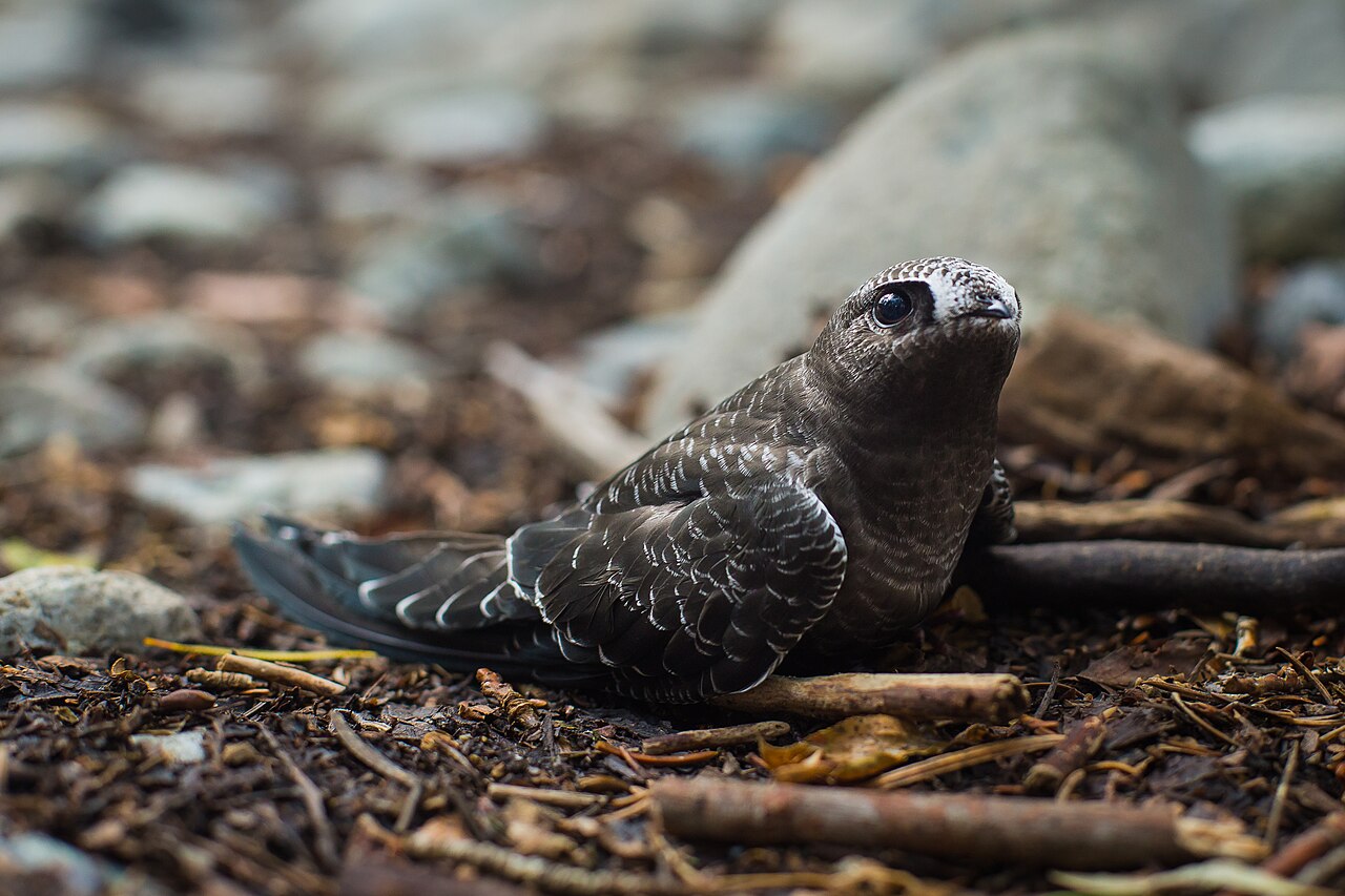
Because it freezes into a column of ice in winter, Zapata draws ice climbers in the cold months, and the area is also one of the few documented Colorado nesting sites for black swifts. For most visitors, though, it is a short, strange, memorable detour — a hidden waterfall you have to wade into a rock chasm to see — and a fine bookend to a trip built around the Great Sand Dunes.
Planning your visit: season, access, and honest expectations
The single most important planning variable is water. Every waterfall here is fed primarily by snowmelt, so the documented best season for all five is the same window — late spring into early summer, roughly May through June. Visit in that stretch and you see these falls at their loudest and fullest. Visit in late summer or fall and several will be noticeably diminished, especially the tall single plunges like Bridal Veil and Fish Creek that depend on a healthy high-country snowpack. A heavy snow year extends the show; a dry one shortens it.
Access ranges widely, so match the fall to your group and your day. Fish Creek Falls, Rifle Falls, and Zapata Falls are all short hikes of roughly half a mile to a mile, suitable for most visitors — though Zapata's creek wade adds real difficulty and cold-water risk. Seven Falls is a short approach but a commercial, ticketed Broadmoor attraction with set hours. Bridal Veil is the most demanding at about 3.6 miles round trip up a steep canyon road. Note the land managers, too: a Forest Service fall, a state park, a BLM site, and two on private land each come with different rules, fees, and access seasons.
Finally, set expectations honestly. These five are a curated selection, not the definitive ranking of every waterfall in Colorado, and the published heights are documented approximations that vary by source and measurement method. What they share is that each is well documented in public records, genuinely worth the trip, and representative of a different corner of the state — the San Juans, the northwest forests, the Front Range, the I-70 corridor, and the Sangre de Cristos. Use them as a backbone and let local Forest Service, state-park, and BLM pages fill in current conditions before you go.