Why Arkansas Punches Above Its Weight for Waterfalls
Arkansas is not the first state most people picture when they think of waterfalls, and that is exactly why its falls feel like a discovery. The Ozark Plateau in the north and the Ouachita Mountains in the west and south are cut by countless creeks and bluff lines, and after a good rain those bluffs come alive. The state is home to the tallest waterfall between the Rocky Mountains and the Appalachians — Hemmed-In Hollow Falls, documented at roughly 209 feet — along with dozens of others that range from roadside cascades to backcountry plunges deep in designated wilderness.
The catch is water. Most Arkansas waterfalls are rain-dependent rather than spring-fed, which means they are seasonal performers. The strongest flows come in late winter and spring, generally from December through April or May, when the ground is saturated and storms roll through. Visit the same spot in August and you may find a damp bluff and a trickle. A handful of falls covered here, such as Triple Falls near Camp Orr, are partly spring-fed and hold water longer, but as a rule the smart play is to chase Arkansas waterfalls within a day or two of significant rainfall.
This is a curated selection, not a complete inventory. Arkansas has hundreds of documented and undocumented falls, and waterfall hunting in the Ozark National Forest is a beloved local pursuit precisely because there is always another one over the next ridge. The fourteen falls below were chosen to span the range of what the state offers — the trophy backcountry hikes, the easy family stops, the state-park headliners, and a couple of roadside gems — while keeping every height, trail distance, and management detail grounded in public records.
The Trophy Hikes: Tallest and Most Remote
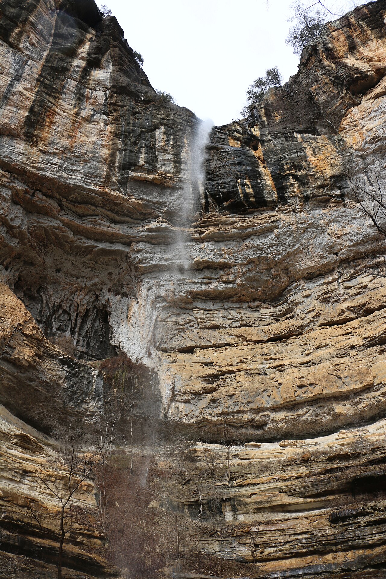
Hemmed-In Hollow Falls is the headliner of any Arkansas waterfall list. Located within Buffalo National River and managed by the National Park Service, it plunges about 209 feet down a sandstone bluff in a box-canyon hollow near Ponca. The falls are fed by an intermittent stream in the Buffalo River drainage, so timing matters enormously — plan for spring, ideally within a day or two of rain, or you risk a long hike to a faint streak on the rock. The most common approach runs roughly 5 to 5.7 miles round trip depending on the route, and it is genuinely strenuous: the trail drops steeply into the hollow and you pay for that descent on the way back out. It is worth every step when the water is running.
Twin Falls of Richland Creek offers a very different kind of remoteness. Set in the Ozark National Forest near Ben Hur and managed by the U.S. Forest Service, this is a segmented waterfall where Big Devil's Fork and Long Devil's Fork pour over a ledge side by side — a striking double-cataract scene when both forks are flowing. The hike is around 4.7 miles round trip at moderate difficulty, but the route involves creek crossings and stretches of unmarked travel, so it earns its backcountry classification. As with the rest of the Richland Creek area, spring after rain is the season to catch it at full strength.
These two falls share a lesson that applies to all of Arkansas's best backcountry waterfalls: the experience is inseparable from the water cycle. Reported heights can also vary by source, since some measurements describe a single sheer drop and others a cumulative cascade — Hemmed-In Hollow's roughly 209-foot figure is widely cited but, like all waterfall heights, should be read as an approximation rather than a surveyed exact. Treat the numbers as a guide to scale, not a guarantee of precision.
State Park Headliners: Reliable Trails, Reliable Payoff
If you want a flagship waterfall without a backcountry commitment, Arkansas's state parks deliver. Cedar Falls in Petit Jean State Park near Morrilton is the most famous of these — a roughly 95-foot plunge on Cedar Creek reached by a moderate trail of about 2.2 miles round trip. Petit Jean is the state's first state park and the trail to Cedar Falls is one of its signature hikes, descending into a canyon to a broad pool at the base. Spring snowmelt and rains, roughly March through May, bring the strongest flow.
Cossatot Falls sits in the Cossatot River State Park-Natural Area near Wickes, in the Ouachitas. This is less a single drop than a series of cascades — documented at around 33 feet — where the Cossatot River drops through a rugged ledge known to whitewater paddlers as one of the most technical runs in the region. A short trail of under a mile reaches the falls, but the real spectacle here is high water: after heavy spring rain, the Cossatot becomes a roaring whitewater staircase. The same conditions that make it beautiful make it dangerous, so respect the river when it is up.
Falls Creek Falls in Lake Catherine State Park near Hot Springs rounds out the state-park trio at the gentler end. It is a modest cascade of about 10 feet on Falls Branch, reached by an easy trail of roughly 1.7 miles round trip. It will not stop traffic on height alone, but it is a rewarding turnaround point on a pleasant loop, and like the others it shows best in spring after rain. For families and casual hikers, these park falls offer a maintained-trail, predictable-access alternative to the forest-service backcountry.
Ozark Short Hikes: Big Reward, Modest Effort
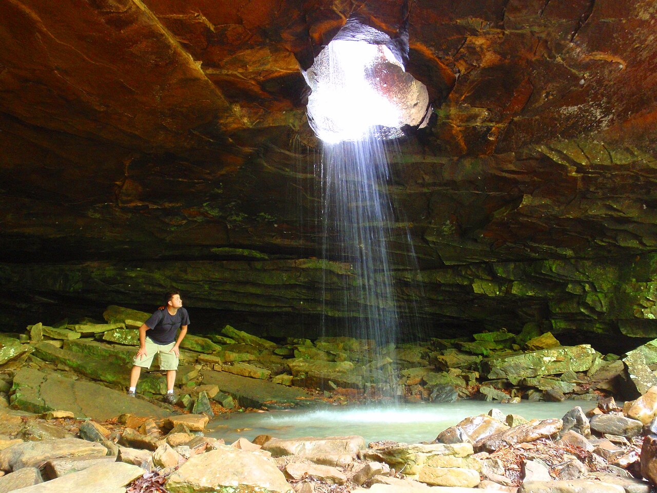
Some of Arkansas's most beloved falls require surprisingly little walking. Glory Hole Falls near Boxley, in the Ozark National Forest, is the most photographed of these: a roughly 30-foot plunge where Dry Branch has bored a hole straight through the roof of an overhanging bluff, so the water drops through the rock rather than over it. The hike runs about 2 miles round trip at moderate difficulty, descending to the bluff line. Winter and spring after rain are best — and in a hard freeze the falls can form dramatic ice formations.
Pam's Grotto Falls near Hagarville is a roughly 37-foot plunge on a tributary of Haw Creek, also in the Ozark-St. Francis National Forest. A short but moderate hike of about a mile reaches a grotto-like amphitheater where the water falls into a shaded alcove — a classic Arkansas bluff-shelter waterfall. Kings Bluff Falls near Pelsor is taller still, documented at about 114 feet, reached by a roughly 1.7-mile moderate loop in the same national forest; it is one of the tallest falls you can reach on a relatively short hike anywhere in the state. Magnolia Falls near Deer, a roughly 26-foot cascade on Cassiatt Branch in the Upper Buffalo Wilderness, asks for about 2.1 miles round trip and rewards with one of the prettiest tiered cascades in the Ozarks.
Two more short-hike falls cluster near the Buffalo River. Lower Eden Falls near Ponca is a tiered fall of about 53 feet on Clark Creek, a Buffalo National River tributary, reached by an easy trail of roughly 2.4 miles round trip that also passes the entrance to Eden Falls Cave for those carrying a flashlight. Triple Falls — also known as Twin Falls at Camp Orr — near Jasper is a segmented fall of about 48 feet on Rock Bridge Creek, reached by a short 0.4-mile walk; because it is partly spring-fed, it holds at least some flow longer into the year than purely rain-dependent falls. All of these peak in spring after rain.
Roadside and Easy Stops Worth a Detour
Not every great Arkansas waterfall demands a hike. Falling Water Falls near Ben Hur, in the Ozark National Forest, is a roughly 10-foot block waterfall on Falling Water Creek that sits essentially roadside along Falling Water Road. It is a popular swimming and photo spot in warmer months and an easy stop for travelers exploring the Richland Creek country. Spring brings the fullest flow, but because it is so accessible it is a worthwhile pause any time water is moving.
Bridal Veil Falls near Heber Springs is another low-effort stop, a roughly 50-foot cascade in the Mossy Creek and Collins Creek area managed by the City of Heber Springs. The walk in is only about 0.3 miles, though the short trail is rated moderate because of the terrain. Like most Arkansas falls it is a spring performer, running best from March through May after rain, and it can be combined with nearby Collins Creek and the Greers Ferry Lake area for a half-day outing.
These accessible falls are the right answer when you are short on time, traveling with kids or less-mobile companions, or simply scouting conditions before committing to a longer hike. If the roadside creeks are running well, that is a strong signal the backcountry falls will be worth the effort too — water levels across a region tend to rise and fall together.
Planning Your Trip: Timing, Safety, and Stewardship
Season is the single most important variable. The reliable window for Arkansas waterfalls runs from roughly December through April or May, with the sweet spot being the days immediately following a soaking rain. Late spring and summer can still produce flow after storms, but extended dry spells reduce many falls to a trickle. Winter offers a bonus: hard freezes can transform falls like Glory Hole and Hemmed-In Hollow into ice features, though that same cold makes trails slick and demands caution.
Match the hike to your party. Roadside stops like Falling Water Falls and short walks to Triple Falls and Bridal Veil suit nearly everyone. Moderate hikes to Cedar Falls, Glory Hole, Kings Bluff, Pam's Grotto, and Magnolia reward a couple of miles of effort on defined trails. The strenuous and backcountry routes — Hemmed-In Hollow and Twin Falls of Richland Creek — involve steep grades, creek crossings, and sometimes route-finding, so carry a map, check forecasts, and never cross high water on foot. Flash flooding is a real hazard in these narrow Ozark and Ouachita drainages, and the high-water conditions that make falls spectacular also make crossings deadly.
Finally, tread lightly. These falls span multiple land managers — the National Park Service at Buffalo National River, the U.S. Forest Service in the Ozark and Ozark-St. Francis National Forests, Arkansas State Parks at Petit Jean, Cossatot, and Lake Catherine, and the City of Heber Springs — each with its own rules on access, camping, and dogs. Check the managing agency before you go, pack out everything you bring, stay on established routes to protect fragile bluff-line vegetation, and leave the streambeds and rock shelters as you found them so the next waterfall hunter finds the same beauty you did.