What Makes a Waterfall a Backcountry Trek
The waterfalls in this guide are not the ones you photograph from a parking lot. They share one trait: getting to them is a project. Some require a multi-day permit reserved months ahead. Some sit at the end of a 20-plus-mile trail. One cannot be reached on foot at all. What they have in common is that the effort and logistics weed out crowds, and the falls themselves tend to be larger, wilder, and more memorable for it.
It helps to separate two tiers. The true backcountry falls — Havasu Falls and Mooney Falls on the Havasupai Reservation in Arizona, Alamere Falls in California's Point Reyes National Seashore, and Mānāwaiopuna Falls (the 'Jurassic Falls' of Kauai, Hawaii) — involve permits, private land, tide windows, or aircraft, and the planning is as much a part of the trip as the hiking. The second tier is the strenuous day hike: long, steep, or high-elevation trails like Yosemite's Mist Trail to Vernal Fall and Nevada Fall, Crabtree Falls in Virginia, Comet Falls at Mount Rainier, and Colorado's Bridal Veil Falls above Telluride. None of these need a backcountry permit, but every one of them rewards — and occasionally punishes — your level of preparation.
A note on the numbers throughout this guide: reported waterfall heights vary widely by source and method. A figure for a single vertical plunge is not comparable to a cumulative height summed over a long cascade, and topographic surveys often disagree with popular guidebooks. Where we cite a height, treat it as an approximation, not a surveyed certainty. Trail mileages are likewise round-trip estimates that shift with the trailhead you choose and the side trips you tack on.
The Permit-Gated Bucket List: Havasu and Mooney Falls, Arizona
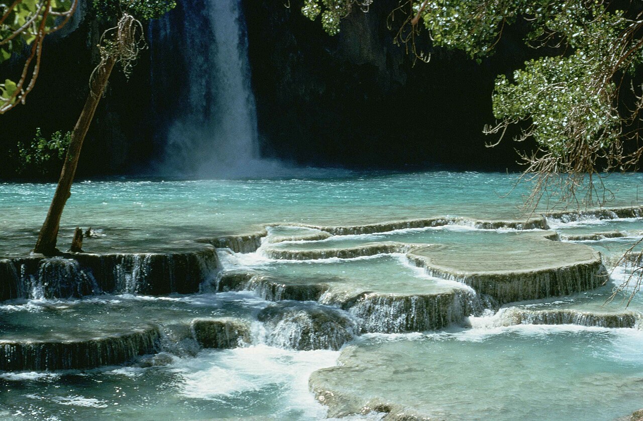
No U.S. waterfall trek is more famous, or more tightly rationed, than the hike to Havasu Falls and Mooney Falls on the Havasupai Tribe's reservation deep in a side canyon of the Grand Canyon. Both falls drop into the turquoise, mineral-rich water of Havasu Creek near the village of Supai. Havasu Falls is roughly a 100-foot plunge about 20 trail miles round trip from the rim; Mooney Falls, the taller of the pair at about 200 feet, lies another mile or so downstream, putting it near 22 round-trip miles. The blue-green color comes from dissolved travertine, and it is the single image most people picture when they think of a desert waterfall.
Access is by permit only, and the rules are strict. Day hiking is not allowed anywhere on Havasupai land — every visitor must hold a reservation, and the campground and lodge are sold exclusively as four-day, three-night permits, whether you want one night or seven. Permits are released through the tribe's official site, havasupaireservations.com, on an annual schedule; for 2026 early access opened January 21 and regular sales began February 1, with campground permits running about $455 per person for the three nights. They sell out fast. Booking through unofficial resellers, or trying to sneak in as a day hiker, is a reliable way to get turned around at Supai. The trip leader named on the reservation must be present at check-in or the permit is void.
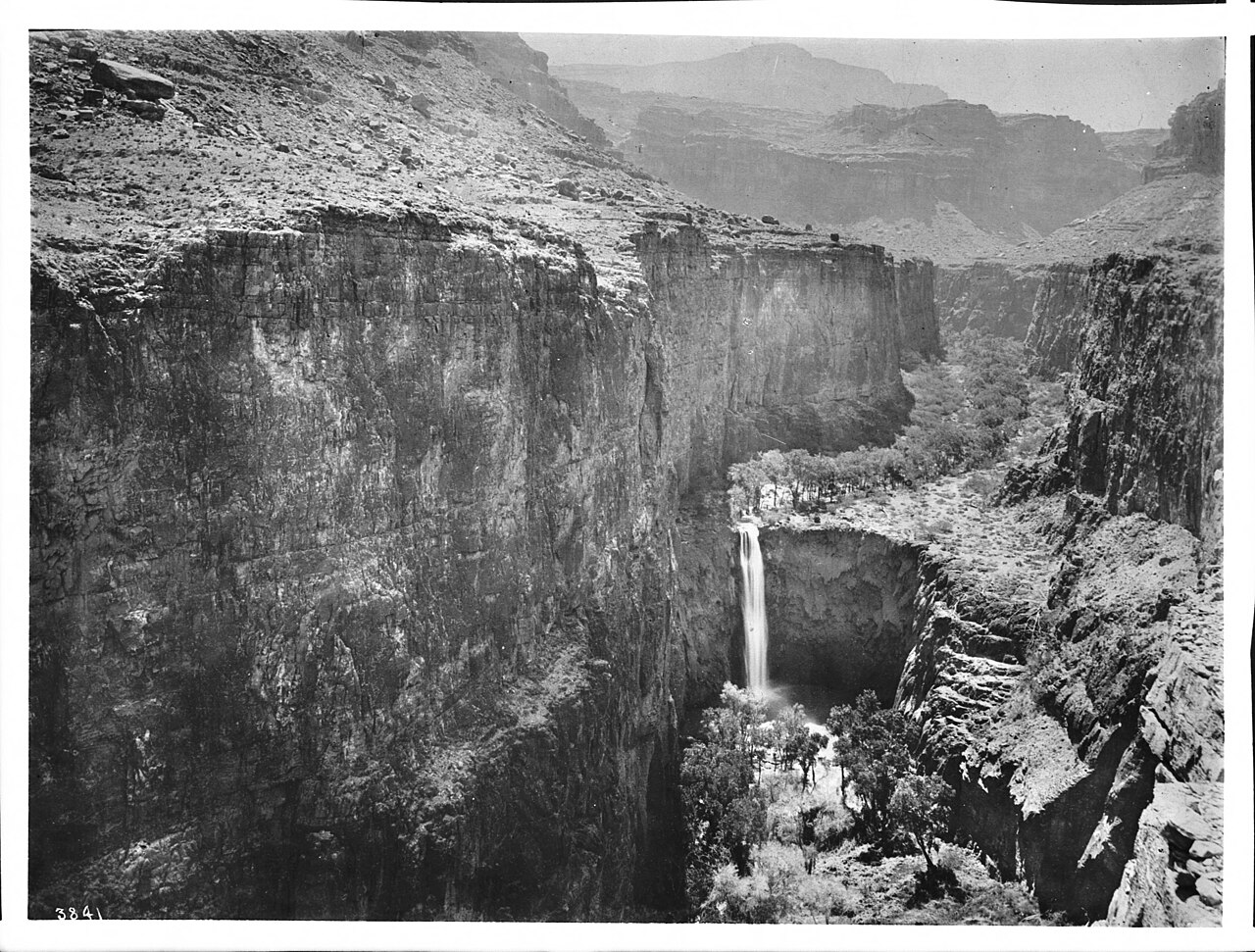
Reaching Mooney Falls is its own test even after you have camped. The base is accessed by a near-vertical 200-foot descent through two tunnels that miners blasted through the travertine in the 1880s, followed by a hand-over-hand climb down bolted chains, iron stakes, and ladders. The chains are routinely slick with spray, the route is single-file with a line at busy hours, and posted signs make clear you descend at your own risk — if you are injured and need a helicopter hoist, you pay for the rescue. The falls is named for D.W. 'James' Mooney, who fell to his death here, and there have been fatalities over the years. The other ever-present hazard is flash flooding in the narrow canyon, so check the forecast before committing to the climb down.
Plan for desert backpacking: this is a 3,000-foot descent on the way in, meaning a long climb out on the final day, usually best done before the heat. The tribe recommends spring and fall — roughly March through May and September through October — to avoid both extreme summer heat and winter cold. Carry far more water capacity than feels necessary, treat creek water, and never camp or store gear in the creek bed.
Coastal and Island Logistics: Alamere Falls and Mānāwaiopuna Falls
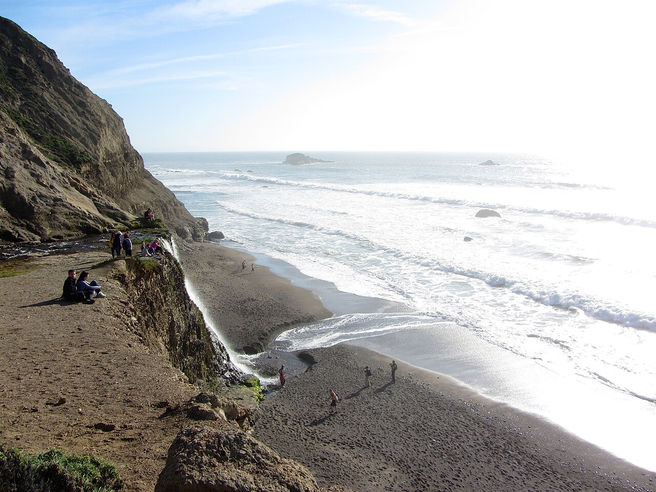
Alamere Falls in Point Reyes National Seashore, California, is a rare 'tidefall' — a tiered cascade roughly 40 feet high that drops directly onto Wildcat Beach and into the Pacific. No permit is required for day hiking, but the logistics are unforgiving in their own way. The standard route from the Palomarin Trailhead near Bolinas is about 13 miles round trip; longer if you start from Bear Valley (around 15 miles) or Five Brooks. The National Park Service is blunt about the access: the final stretch along Wildcat Beach can be impassable at high tide or during high surf, so you must check tide predictions and the National Weather Service advisories and time your arrival for low tide. Pets are prohibited on all trails to the falls, and overnight stays require a backcountry camping permit for Wildcat Campground.
The takeaway with Alamere is that the danger is not elevation or remoteness but timing and surf. People scramble down unofficial, eroding bluff routes to reach the lower falls and get hurt; the safer approach is the established beach walk at low tide. Treat the tide chart as a hard constraint, not a suggestion, and give yourself a wide margin to be off the beach before the water comes up.
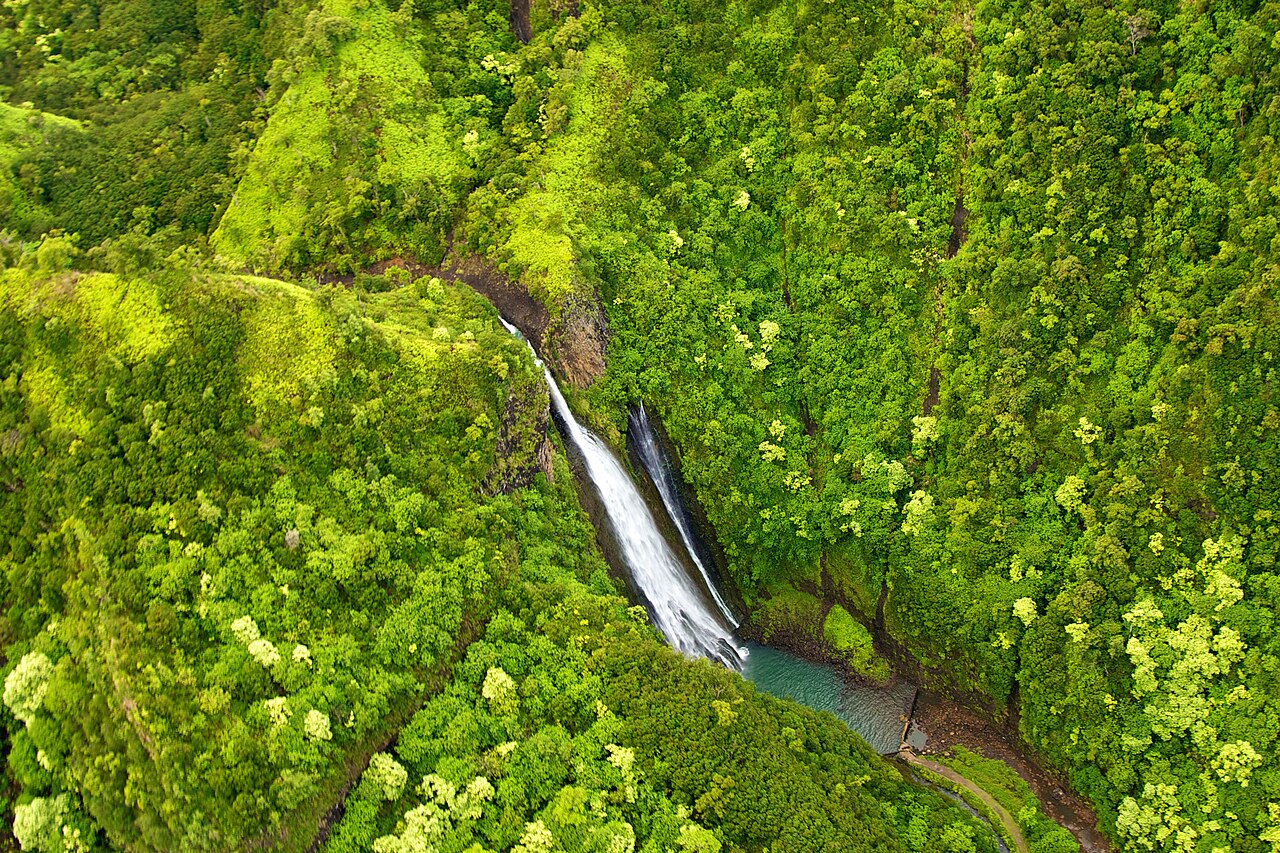
Mānāwaiopuna Falls on Kauai — known to most people as 'Jurassic Falls' after its appearance in the background of the 1993 film Jurassic Park — represents the opposite extreme of access: you cannot hike to it at all. The roughly 400-foot plunge sits on private land in the dense, trail-less Hanapēpē Valley, owned by the Robinson family. There is no public trail, no road, and no legal walk-in route. Since 2009 the family has granted exclusive landing rights to a single operator, Island Helicopters, whose tour is the only sanctioned way to stand at the base of the falls. We include it here precisely because 'prepared' sometimes means accepting that the right and lawful way to see a place is a paid, permitted flight — not a bushwhack onto private property.
Strenuous Day Hikes That Earn Their Crowds
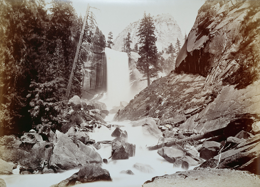
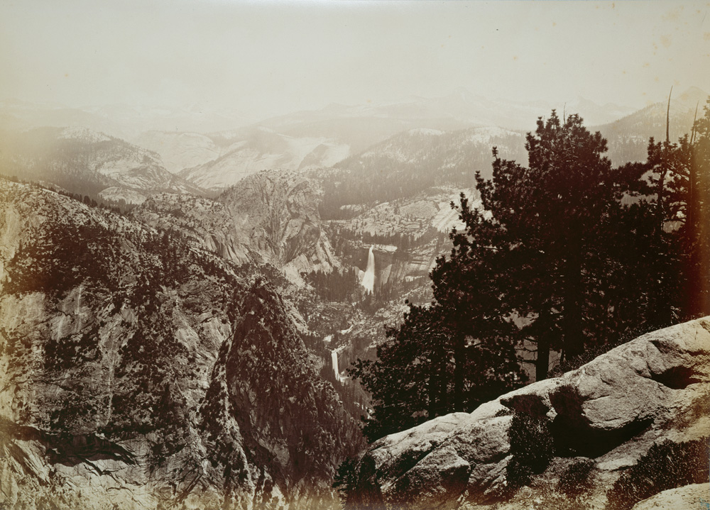
Not every demanding waterfall needs a multi-day permit. Yosemite's Mist Trail is the best example of a strenuous day hike that punishes the unprepared. From the valley floor it climbs past Vernal Fall — a roughly 317-foot block waterfall on the Merced River reached in about 2.6 miles round trip with around 1,000 feet of gain — and continues to Nevada Fall, a roughly 594-foot horsetail about 5.4 miles round trip with closer to 1,900 feet of gain. The granite steps beside Vernal Fall are soaked in spray during the late-spring snowmelt (May and June are peak flow), and people are swept over the falls every few years after entering the river above the lip. Stay behind railings, keep out of the water, and know that the Mist Trail portion closes in winter, when the John Muir Trail becomes the snowy alternative. The same corridor is the launch point for the permit-required Half Dome cables — a separate, far more committing objective.
Crabtree Falls in Virginia's George Washington National Forest is often called one of the tallest waterfalls east of the Mississippi, but the number deserves a caveat. It is a series of five major cascades on Crabtree Creek; the full set is popularly cited near 1,000 to 1,200 feet of cumulative drop, while the tallest single cascade is closer to 400 feet. The trail to the upper overlooks runs roughly 3.4 miles round trip and gains steady elevation. The recurring tragedy here is people leaving the marked trail to scramble on the wet, mossy rock beside the falls — there have been numerous fatalities. The cascade is worth the climb; the off-trail rocks are not.
In Washington, Comet Falls in Mount Rainier National Park is a roughly 320-foot tiered drop on Van Trump Creek, reached by a steep 3.8-mile round-trip trail that gains substantial elevation through forest and subalpine meadow. The trail is only reliably snow-free in summer — plan for July through September — and early-season hikers regularly underestimate lingering snow on the upper switchbacks. Colorado's Bridal Veil Falls above Telluride, the state's tallest free-falling waterfall at about 365 feet, is a different kind of test: the roughly 3.6-mile round-trip route is a steep, exposed shelf road with high-altitude air and late-lying snow, best in the May–June snowmelt window. The historic powerhouse perched at its lip is on private land tied to the old Idarado mining operation, so admire it and respect the boundaries.
How to Plan, Permit, and Stay Safe
Start with the permit calendar, because it is the one thing you cannot fix at the last minute. Havasupai permits are released on a fixed annual date through the tribe's official reservation site and sell out within hours — build your whole trip around that release, not the other way around. For Yosemite, the falls themselves need no permit, but Half Dome and overnight wilderness travel do, and those have their own lotteries and quotas. Point Reyes day hiking is permit-free, but Wildcat Campground requires a backcountry permit and Alamere requires a low-tide window. Confirm current rules directly with the managing agency — the National Park Service, U.S. Forest Service, or the tribe — before you finalize anything, because fees, dates, and quotas change yearly.
Match your season to the falls' water and the trail's conditions, and accept that these often conflict. Peak flow at snowmelt waterfalls like Yosemite's, Crabtree, Comet, and Bridal Veil arrives in spring and early summer — exactly when high water makes wet rock and river edges most lethal. Havasupai and other desert routes flip the logic: spring and fall avoid dangerous summer heat, but they are also flash-flood season in slot and side canyons. The constant across all of them is that the conditions that make a waterfall spectacular are usually the same conditions that make it dangerous.
Pack and behave like the trip is harder than the mileage suggests. Carry the ten essentials, real navigation that does not depend on cell signal, and far more water capacity than a comparable flat hike would need — long climbs out (Havasupai's 3,000-foot ascent, the Mist Trail's granite stairs) magnify dehydration. Check tide tables, flash-flood forecasts, and snow reports as hard go/no-go inputs, not afterthoughts. And internalize the single most repeated lesson at every one of these falls: nearly every fatality involves someone who left the marked trail, climbed wet rock for a better view, or entered moving water above a drop. The overlooks and railings exist because the alternative has a body count. Stay on the trail, behind the rail, and out of the current.